Templat:Infobox earthquake/doc: Perbedaan antara revisi
Tampilan
Konten dihapus Konten ditambahkan
k Robot: Perubahan kosmetika |
|||
| Baris 73: | Baris 73: | ||
{{UF-hcal}} |
{{UF-hcal}} |
||
==Lihat pula== |
== Lihat pula == |
||
*{{tl|Infobox flood}} |
*{{tl|Infobox flood}} |
||
*{{tl|Infobox hurricane}} |
*{{tl|Infobox hurricane}} |
||
| Baris 81: | Baris 81: | ||
<includeonly> |
<includeonly> |
||
<!-- CATEGORIES HERE, THANKS --> |
<!-- CATEGORIES HERE, THANKS --> |
||
[[ |
[[Kategori:Templat gempa bumi|Gempa bumi]] |
||
[[ |
[[Kategori:Templat kotakinfo geologi|Gempa bumi]] |
||
</includeonly> |
</includeonly> |
||
Revisi per 13 Mei 2016 22.48
Penggunaan
{{Infobox earthquake
|name        =
|image       = <!-- nama berkasnya saja -->
|alt         =
|caption     =
|map         = <!-- nama berkasnya saja -->
|map_alt     =
|map_caption =
|map2        = <!-- peta manual map atau gunakan {{Location map}} -->
|date        = <!-- {{Start date|YYYY|MM|DD}} -->
|time        =
|duration    =
|magnitude   = <!-- NNN [[skala kekuatan Moment|M<sub>w</sub>]] -->
|depth       = <!-- {{convert|NNN|km|mi|0|abbr=on}} -->
|location    = <!-- {{coord|XXXXX|region:XX_type:event|display=inline,title}} -->
|type        =
|affected    =
|damages     = <!-- kerugian/rentang kerusakan bangunan -->
|intensity   =
|pga         = <!-- NN''[[Akselerasi darat puncak|g]]'' -->
|tsunami     =
|landslide   =
|foreshocks  =
|aftershocks =
|casualties  =
}}
Contoh
 Tumpukan reruntuhan, satu minggu setelah gempa | |
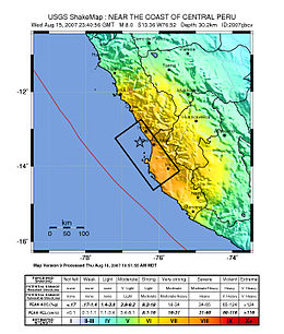
 Peta garis pantai Peru, menampilkan lokasi dan kekuatan gempa. Episentrum ditandai oleh bintang. | |
| Tanggal * | 15 Agustus 2007 |
|---|---|
| Waktu awal * | 23:40:57 UTC |
| Kekuatan | 8.0 Mw |
| Kedalaman | 39 km (24 mi) |
| Episentrum | 13°21′14″S 76°30′32″W / 13.354°S 76.509°W |
| Wilayah bencana | Region Ica (Pisco, Ica dan Chincha Alta) dan Region Lima (San Vicente de Cañete) |
| Tsunami | Membanjiri sebagian jalan tol Costa Verde Lima, dan sebagian besar pesisir Pisco |
| Korban | 519 tewas, 1.366 cedera |
| * Usang | Lihat dokumentasi. |
{{Infobox earthquake
|name        = Gempa bumi Peru 2007
|image       = 40 - Tremblement de terre - Août 2007.JPG
|alt         = Foto kerusakan gempa.
|caption     = Tumpukan reruntuhan, satu minggu setelah gempa
|map         = Peru Quake Aug 15-2007.jpg
|map_alt     = Peta garis pantai Peru, menampilkan lokasi dan kekuatan gempa.
|map_caption = <small>Peta garis pantai Peru, menampilkan lokasi dan kekuatan gempa. [[Episentrum]] ditandai oleh bintang.</small>
|date        = {{Start date|2007|8|15}}
|time        = 23:40:57 [[UTC]]
|magnitude   = 8.0 [[Skala kekuatan Moment|M<sub>w</sub>]]
|depth       = {{convert|39|km|mi|abbr=on}}
|location    = {{coord|13.354|S|76.509|W|region:PE_type:event|display=inline,title}}
|affected    = [[Region Ica]] ([[Pisco, Peru|Pisco]], [[Ica (kota)|Ica]] dan [[Chincha Alta]]) dan [[Region Lima]] ([[San Vicente de Cañete]])
|tsunami     = Membanjiri sebagian jalan tol Costa Verde Lima, dan sebagian besar pesisir Pisco
|casualties  = 519 tewas, 1.366 cedera
}}
Format mikro
The HTML mark-up produced by this template includes an hCalendar microformat that makes event details readily parsable by computer programs. This aids tasks such as the cataloguing of articles and maintenance of databases. For more information about the use of microformats on Wikipedia, please visit the Microformat WikiProject.
- Classes used
The HTML classes this microformat uses include:
- attendee
- contact
- description
- dtend
- dtstart
- location
- organiser
- summary
- url
- vevent
line-height:1.3em
Lihat pula
- {{Infobox flood}}
- {{Infobox hurricane}}
- {{Infobox storm}}
- {{Infobox tornado}}
