
Ifugao
Ifugao | |
|---|---|
 | |
 Bendera  Lambang | |
 Location in the Philippines | |
| Negara | Filipina |
| Region | Cordillera Administrative Region (CAR) |
| Didirikan | June 18, 1966 |
| Ibukota | Lagawe |
| Pemerintahan | |
| • Jenis | Province of the Philippines |
| • Gubernur | Denis Habawel (Independent) |
| • Wakil gubernur | Pedro Mayam-o (LP) |
| Luas | |
| • Total | 2.628,21 km2 (101,476 sq mi) |
| Peringkat | 51st out of 81 |
| Populasi (2010)[2] | |
| • Total | 191.078 |
| • Peringkat | 72nd out of 81 |
| • Kepadatan | 0,73/km2 (1,9/sq mi) |
| • Peringkat kepadatan | 74th out of 81 |
| Divisi | |
| • Independent cities | 0 |
| • Kota komponen | 0 |
| • Munisipalitas | 11 |
| • Barangay | 175 |
| • Districts | Lone district of Ifugao |
| Zona waktu | UTC+8 |
| ZIP code | 3600 to 3610 |
| Kode area telepon | 74 |
| Kode ISO 3166 | PH-IFU |
| Bahasa daerah | Ifugao, Ilocano, Tuwali, Ayangan, Kalanguya, Tagalog, English |
Ifugao merupakan sebuah provinsi di Filipina. Ibu kotanya ialah Lagawe. Provinsi ini terletak di Region Administratif Cordillera. Provinsi ini memiliki luas wilayah 2.628,2 km² dengan memiliki jumlah penduduk 180.711 jiwa (2007). Provinsi ini memiliki angka kepadatan penduduk 69 jiwa/km².
Pembagian wilayah[sunting | sunting sumber]
Secara administratif provinsi Ifugao terbagi menjadi 11 munisipalitas, yaitu:
Galeri[sunting | sunting sumber]
-
 Banaue Rice Terraces di provinsi Ifugao
 -
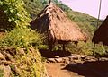 Rumah tradisional di Ifugao menyerupai puncak gunung


Referensi[sunting | sunting sumber]
- ^ "List of Provinces". PSGC Interactive. Makati City, Philippines: National Statistical Coordination Board. Diarsipkan dari versi asli tanggal 2013-01-11. Diakses tanggal 20 December 2013.
- ^ "Total Population by Province, City, Municipality and Barangay: as of May 1, 2010" (PDF). 2010 Census of Population and Housing. National Statistics Office. Diarsipkan dari versi asli (PDF) tanggal 2013-11-14. Diakses tanggal 20 December 2013.
Pranala luar[sunting | sunting sumber]
- Philippine Standard Geographic Code Diarsipkan 2012-04-13 di Wayback Machine.
- 2000 Philippine Census Information
- 2007 Philippine Census Information Diarsipkan 2008-12-20 di Wayback Machine.
Koordinat: 16°50′N 121°10′E / 16.833°N 121.167°E
| Munisipalitas | |
|---|---|

| Umum | |
|---|---|
| Perpustakaan nasional | |
Artikel bertopik geografi atau tempat Filipina ini adalah sebuah rintisan. Anda dapat membantu Wikipedia dengan mengembangkannya. |