Mykale: Perbedaan antara revisi
Tampilan
Konten dihapus Konten ditambahkan
k Bot: Migrasi 15 pranala interwiki, karena telah disediakan oleh Wikidata pada item d:Q1330828 |
k Bot: +{{Authority control}} |
||
| (2 revisi perantara oleh 2 pengguna tidak ditampilkan) | |||
| Baris 1: | Baris 1: | ||
{{Infobox mountain |
{{Infobox mountain |
||
| |
|name = '''Mount Mycale''' |
||
| |
|other_name = Μυκάλη<br />Samsun Daği |
||
| |
|photo = Priene.jpg |
||
| |
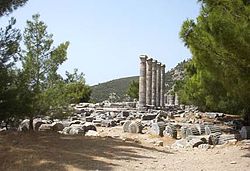
|photo_caption = Bagian samping Mykale di belakang [[Priene]] |
||
| |
|photo_size = 250 |
||
| |
|elevation_m = 1237 |
||
| |
|elevation_ref = di Dilek Tepesi, the high point; {{convert|600|m|ft|0}} average |
||
| |
|prominence = |
||
| |
|listing = |
||
| |
|translation = [[Priene|Gunung Samson]] |
||
| |
|language = [[bahasa Turki]] |
||
| |
|location = Provinsi [[Aydin]], [[Turki]] |
||
| |
|range = Aydin Mountain Range in the Menderes Massif |
||
| |
|map =Turkey relief |
||
| |
|map_size = |
||
| |
|label_position = right |
||
| |
|lat_d = 37 |lat_m = 40|lat_s =|lat_NS = N |
||
| |
|long_d = 27 |long_m =05 |long_s = |long_EW = E |
||
| |
|topo = |
||
| |
|type = [[Ridge]], {{convert|200|km|mi|0}} long |
||
| |
|age = |
||
| |
|volcanic_arc/belt = |
||
| |
|last_eruption = |
||
| |
|first_ascent = |
||
| |
|easiest_route = Hike |
||
}} |
}} |
||
| Baris 33: | Baris 33: | ||
== Pranala luar == |
== Pranala luar == |
||
* {{cite web|last=Lendering|first=Jona|authorlink=Jona Lendering|title=Mycale (Dilek Dagi)|publisher=Livius articles on ancient history|date=1996-2008|url=http://www.livius.org/a/turkey/mycale/mycale.html|accessdate=2008-01-31 |
* {{cite web|last=Lendering|first=Jona|authorlink=Jona Lendering|title=Mycale (Dilek Dagi)|publisher=Livius articles on ancient history|date=1996-2008|url=http://www.livius.org/a/turkey/mycale/mycale.html|accessdate=2008-01-31|archiveurl=https://web.archive.org/web/20080101093748/http://www.livius.org/a/turkey/mycale/mycale.html|archivedate=2008-01-01|dead-url=no}} |
||
* {{cite web|first=Ugur|last=Zeydanlı|coauthors=Hilary Welch; Geoff Welch|title=Aegean and Western Turkey sclerophyllous and mixed forests|work=WWF Full Report|publisher=www.worldlife.org|year=2001|url=http://www.worldwildlife.org/wildworld/profiles/terrestrial/pa/pa1201_full.html|accessdate=2008-01-31}} |
* {{cite web|first=Ugur|last=Zeydanlı|coauthors=Hilary Welch; Geoff Welch|title=Aegean and Western Turkey sclerophyllous and mixed forests|work=WWF Full Report|publisher=www.worldlife.org|year=2001|url=http://www.worldwildlife.org/wildworld/profiles/terrestrial/pa/pa1201_full.html|accessdate=2008-01-31}} |
||
{{Authority control}} |
|||
[[Kategori:Gunung di Turki]] |
[[Kategori:Gunung di Turki]] |
||
Revisi terkini sejak 4 Juli 2021 12.35
| Mount Mycale | |
|---|---|
| Μυκάλη Samsun Daği | |
 Bagian samping Mykale di belakang Priene | |
| Titik tertinggi | |
| Ketinggian | 1.237 m (4.058 ft)di Dilek Tepesi, the high point; 600 meter (1.969 ft) average |
| Penamaan | |
| Nama terjemahan | Gunung Samson (bahasa Turki) |
| Geografi | |
| Pegunungan | Aydin Mountain Range in the Menderes Massif |
| Geologi | |
| Jenis gunung | Ridge, 200 kilometer (124 mi) long |
| Pendakian | |
| Rute termudah | Hike |
Mykale atau Mycali (bahasa Yunani Kuno: Μυκάλη), disetbu Samsun Daği dan Dilek Daği di Turki modern, adalah gunung di pesisir barat Anatolia tengah di Turki, sebelah utara muara sungai Meandros dan terpisah dari pulau Samos di Yunani sejauh 1300 meter oleh Selatt Samos. Gunung ini membentuk punggung bukit, berakhir di tempat yang pada masa kuno dikenal sebagai tanjung Trogilion (bahasa Yunani kuno Τρωγίλιον or Τρωγύλιον).[1] Ada beberapa pantai di pesisir utaranya, mulai dari yang berpasir hingga berkerikir. Bagin selatannya sebagian besar berupa lereng curam.
Catatan kaki
[sunting | sunting sumber]- ^ Smith, William (1850). "Mycale". New Classical Dictionary of Biography, Mythology and Geography. London: John Murray.. Downloadable Google Books.
Pranala luar
[sunting | sunting sumber]- Lendering, Jona (1996–2008). "Mycale (Dilek Dagi)". Livius articles on ancient history. Diarsipkan dari versi asli tanggal 2008-01-01. Diakses tanggal 2008-01-31.
- Zeydanlı, Ugur (2001). "Aegean and Western Turkey sclerophyllous and mixed forests". WWF Full Report. www.worldlife.org. Diakses tanggal 2008-01-31.

