
Holborn: Perbedaan antara revisi
Konten dihapus Konten ditambahkan
Text added & edited |
k →top: clean up |
||
| (2 revisi perantara oleh 2 pengguna tidak ditampilkan) | |||
| Baris 3: | Baris 3: | ||
|static_image_name = 142 Holborn Bars, London.jpg |
|static_image_name = 142 Holborn Bars, London.jpg |
||
|static_image_caption = Holborn Bars dibangun tahun 1879–1901, kantor pusat [[Prudential plc|Prudential Assurance]], beralamat di 138–142 Holborn |
|static_image_caption = Holborn Bars dibangun tahun 1879–1901, kantor pusat [[Prudential plc|Prudential Assurance]], beralamat di 138–142 Holborn |
||
|region = [London]] |
|region = [[London]] |
||
|official_name = Holborn |
|official_name = Holborn |
||
|coordinates = {{coord|51.5172|-0.1182|display=inline,title}} |
|coordinates = {{coord|51.5172|-0.1182|display=inline,title}} |
||
| Baris 10: | Baris 10: | ||
|london_borough2 = Westminster |
|london_borough2 = Westminster |
||
|population = 13.023 |
|population = 13.023 |
||
|population_ref = (Sensus 2011, Holborn dan Covent Garden Ward)<ref>{{cite web|url=http://www.neighbourhood.statistics.gov.uk/dissemination/LeadKeyFigures.do?a=7&b=13688645&c=Holborn+and+Covent+Garden&d=14&e=62&g=6321731&i=1001x1003x1032x1004&o=362&m=0&r=1&s=1476970199284&enc=1|title=Camden Ward population 2011|accessdate=20 October 2016|publisher=Office for National Statistics |
|population_ref = (Sensus 2011, Holborn dan Covent Garden Ward)<ref>{{cite web|url=http://www.neighbourhood.statistics.gov.uk/dissemination/LeadKeyFigures.do?a=7&b=13688645&c=Holborn+and+Covent+Garden&d=14&e=62&g=6321731&i=1001x1003x1032x1004&o=362&m=0&r=1&s=1476970199284&enc=1|title=Camden Ward population 2011|accessdate=20 October 2016|publisher=Office for National Statistics|work=Neighbourhood Statistics|archive-date=2017-05-10|archive-url=https://web.archive.org/web/20170510084518/http://www.neighbourhood.statistics.gov.uk/dissemination/LeadKeyFigures.do?a=7&b=13688645&c=Holborn+and+Covent+Garden&d=14&e=62&g=6321731&i=1001x1003x1032x1004&o=362&m=0&r=1&s=1476970199284&enc=1|dead-url=yes}}</ref> |
||
|post_town = LONDON |
|post_town = LONDON |
||
|postcode_area = WC |
|postcode_area = WC |
||
| Baris 21: | Baris 21: | ||
'''Holborn''' ({{IPAc-en|ˈ|h|əʊ|b|ə|n}} {{respell|HOH|bə(r)n}}<!--not just a local pronunciation--> or {{IPAc-en|'|h|ɒ|l|b|ər|n}} {{Ref label|a|a|none}}) adalah distrik di [[Borough London|London boroughs]] [[London Borough of Camden|Camden]] dan [[City of Westminster]] serta sebuah "[[Wards of the City of London|ward]]" di [[Farringdon Without]], [[City of London]]. Daerah Holborn terkadang dianggap sebagai bagian dari [[West End of London]].<ref>https://www3.camden.gov.uk/westendproject/wp-content/uploads/2018/06/Project-Overview-for-website-1.pdf LBC website describing improvements in a part of the borough they refer to as 'West End'</ref> |
'''Holborn''' ({{IPAc-en|ˈ|h|əʊ|b|ə|n}} {{respell|HOH|bə(r)n}}<!--not just a local pronunciation--> or {{IPAc-en|'|h|ɒ|l|b|ər|n}} {{Ref label|a|a|none}}) adalah distrik di [[Borough London|London boroughs]] [[London Borough of Camden|Camden]] dan [[City of Westminster]] serta sebuah "[[Wards of the City of London|ward]]" di [[Farringdon Without]], [[City of London]]. Daerah Holborn terkadang dianggap sebagai bagian dari [[West End of London]].<ref>https://www3.camden.gov.uk/westendproject/wp-content/uploads/2018/06/Project-Overview-for-website-1.pdf LBC website describing improvements in a part of the borough they refer to as 'West End'</ref> |
||
Daerah ini pertama kali disebut dalam piagam [[Biara Westminster]], oleh [[Edgar dari Inggris|Raja Edgar]] pada tahun 959. Dalam piagam tersebut tertulis "gereja kayu tua St Andrew, Holborn".<ref name=lethaby>{{cite book|last= Lethaby|first= William|authorlink= William Lethaby|title= London before the conquest|url= https://archive.org/details/londonbeforeconq00lethrich|publisher= Macmillan|location= London|year= 1902|page= [https://archive.org/details/londonbeforeconq00lethrich/page/60 60]}}</ref> Nama "Holborn" kemungkinan berasal dari [[Bahasa Inggris Pertengahan]] ''hol'' dari kata "hollow", dan ''bourne'', sebuah "brook" (anak sungai) yang merujuk pada [[Sungai Fleet]] yang mengalir melalui lembah curam ke arah timur.<ref name=lethaby /><ref name=besant>{{cite book|last= Besant|first= Walter|authorlink= Walter Besant|author2= Mitton, Geraldine|title= Holborn and Bloomsbury|publisher= [[A & C Black|Adam and Charles Black]]|location= London|year= 1903|edition= Project Gutenberg, 2007|series= The Fascination of London|url= http://www.gutenberg.org/files/21411/21411-8.txt|accessdate= 13 August 2008}}</ref> |
Daerah ini pertama kali disebut dalam piagam [[Biara Westminster]], oleh [[Edgar dari Inggris|Raja Edgar]] pada tahun 959. Dalam piagam tersebut tertulis "gereja kayu tua St Andrew, Holborn".<ref name=lethaby>{{cite book|last= Lethaby|first= William|authorlink= William Lethaby|title= London before the conquest|url= https://archive.org/details/londonbeforeconq00lethrich|publisher= Macmillan|location= London|year= 1902|page= [https://archive.org/details/londonbeforeconq00lethrich/page/60 60]}}</ref> Nama "Holborn" kemungkinan berasal dari [[Bahasa Inggris Pertengahan]] ''hol'' dari kata "hollow", dan ''bourne'', sebuah "brook" (anak sungai) yang merujuk pada [[Sungai Fleet]] yang mengalir melalui lembah curam ke arah timur.<ref name=lethaby /><ref name=besant>{{cite book|last= Besant|first= Walter|authorlink= Walter Besant|author2= Mitton, Geraldine|title= Holborn and Bloomsbury|publisher= [[A & C Black|Adam and Charles Black]]|location= London|year= 1903|edition= Project Gutenberg, 2007|series= The Fascination of London|url= http://www.gutenberg.org/files/21411/21411-8.txt|accessdate= 13 August 2008}}</ref> |
||
== Galeri == |
== Galeri == |
||
| Baris 33: | Baris 33: | ||
{{Reflist}} |
{{Reflist}} |
||
[[Kategori:Holborn]] |
[[Kategori:Holborn| ]] |
||
Revisi terkini sejak 9 Januari 2023 18.41
| Holborn | |
 Holborn Bars dibangun tahun 1879–1901, kantor pusat Prudential Assurance, beralamat di 138–142 Holborn |
|
| Population | 13.023 (Sensus 2011, Holborn dan Covent Garden Ward)[1] |
|---|---|
| Ref. grid OS | TQ305815 |
| London Raya | |
| Region | |
| Negara konstituen | Inggris |
| Negara berdaulat | Britania Raya |
| Kota pos | LONDON |
| Distrik kode pos | WC1, WC2 |
| Distrik kode pos | EC1 |
| Kode telepon | 020 |
| Polisi | |
| Pemadam kebakaran | |
| Ambulans | |
| Parlemen UE | [[London (daerah pemilihan Parlemen Eropa)|London]] |
| Majelis London | |
| Daftar tempat: Britania Raya • Inggris • | |
Holborn (/ˈhoʊbən/ HOH-bə(r)n or /ˈhɒlbərn/ [a]) adalah distrik di London boroughs Camden dan City of Westminster serta sebuah "ward" di Farringdon Without, City of London. Daerah Holborn terkadang dianggap sebagai bagian dari West End of London.[2]
Daerah ini pertama kali disebut dalam piagam Biara Westminster, oleh Raja Edgar pada tahun 959. Dalam piagam tersebut tertulis "gereja kayu tua St Andrew, Holborn".[3] Nama "Holborn" kemungkinan berasal dari Bahasa Inggris Pertengahan hol dari kata "hollow", dan bourne, sebuah "brook" (anak sungai) yang merujuk pada Sungai Fleet yang mengalir melalui lembah curam ke arah timur.[3][4]
Galeri
[sunting | sunting sumber]-
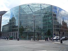 Kantor pusat perusahaan Sainsbury's di Holborn Circus
 -
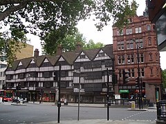 Staple Inn, dekat stasiun kereta bawah tanah Chancery Lane
 -
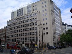 Grange Holborn Hotel


Referensi
[sunting | sunting sumber]- ^ "Camden Ward population 2011". Neighbourhood Statistics. Office for National Statistics. Diarsipkan dari versi asli tanggal 2017-05-10. Diakses tanggal 20 October 2016.
- ^ https://www3.camden.gov.uk/westendproject/wp-content/uploads/2018/06/Project-Overview-for-website-1.pdf LBC website describing improvements in a part of the borough they refer to as 'West End'
- ^ a b Lethaby, William (1902). London before the conquest. London: Macmillan. hlm. 60.
- ^ Besant, Walter; Mitton, Geraldine (1903). Holborn and Bloomsbury. The Fascination of London (edisi ke-Project Gutenberg, 2007). London: Adam and Charles Black. Diakses tanggal 13 August 2008.