Region Kayes: Perbedaan antara revisi
Tampilan
Konten dihapus Konten ditambahkan
k →Referensi: clean up |
|||
| (4 revisi perantara oleh 4 pengguna tidak ditampilkan) | |||
| Baris 1: | Baris 1: | ||
{{Infobox settlement |
|||
{{kembangkan}}[[Berkas:Mali-Kayes.png|right|200px|Letak Kayes di Mali]] |
|||
<!-- See Template:Infobox settlement for additional fields and descriptions --> |
|||
| name = Kayes Region |
|||
| native_name = |
|||
| native_name_lang = fr<!-- ISO 639-2 code e.g. "fr" for French language --> |
|||
| type = [[Regions of Mali|Region]] |
|||
| image_skyline = Sahel forest near Kayes Mali.jpg |
|||
| image_alt = |
|||
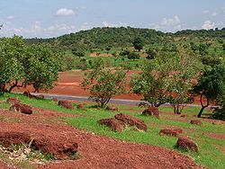
| image_caption = Sahel forest |
|||
| nickname = |
|||
| motto = |
|||
| image_map = Mali - Kayes.svg |
|||
| map_alt = |
|||
| map_caption = Location within Mali |
|||
| mapsize = 300px |
|||
| latd = 14|latm = 6|lats = 54|latNS = N |
|||
| longd = 10|longm = 34|longs = 7|longEW = W |
|||
| coordinates_type = type:adm1st_region:ML_source:nlwiki |
|||
| coordinates_display = inline,title |
|||
| coordinates_footnotes = |
|||
| subdivision_type = [[List of sovereign states|Country]] |
|||
| subdivision_name = {{flag|Mali}} |
|||
| established_title = |
|||
| established_date = |
|||
| founder = |
|||
| named_for = |
|||
| seat_type = [[Capital (political)|Capital]] |
|||
| seat = [[Kayes]] |
|||
| government_footnotes = |
|||
| leader_party = |
|||
| leader_title = |
|||
| leader_name = |
|||
| area_footnotes = |
|||
| area_total_km2 = 119743 |
|||
| area_note = |
|||
| elevation_footnotes = |
|||
| elevation_m = |
|||
| population_footnotes =<ref name=pop2009>{{citation | url=http://instat.gov.ml/documentation/kayes.pdf | publisher=République de Mali: Institut National de la Statistique | title=Resultats Provisoires RGPH 2009 (Région de Kayes) | language=French | archiveurl=https://www.webcitation.org/6AnXrhnbD?url=http://instat.gov.ml/documentation/kayes.pdf | archivedate=2012-09-19 | deadurl=no | accessdate=2016-06-22 }}.</ref> |
|||
| population_total = 1996812 |
|||
| population_as_of = 2009 census |
|||
| population_density_km2 = auto |
|||
| population_demonym = |
|||
| population_note = |
|||
| timezone1 = [[UTC±0|UTC]] |
|||
| utc_offset1 = ±0 |
|||
| postal_code_type = |
|||
| postal_code = |
|||
| area_code_type = |
|||
| area_code = |
|||
| website = |
|||
| footnotes = |
|||
}} |
|||
'''Region Kayes''' merupakan sebuah region di [[Mali]]. Ibu kotanya ialah [[Kayes]]. Region ini berbatasan dengan [[Mauritania]] di utara, [[Senegal]] di barat, [[Guinea]] di selatan, dan [[Region Koulikoro]] di timur. |
'''Region Kayes''' merupakan sebuah region di [[Mali]]. Ibu kotanya ialah [[Kayes]]. Region ini berbatasan dengan [[Mauritania]] di utara, [[Senegal]] di barat, [[Guinea]] di selatan, dan [[Region Koulikoro]] di timur. |
||
== Referensi == |
|||
| ⚫ | |||
{{Reflist}} |
|||
[[Kategori:Region di Mali]] |
[[Kategori:Region di Mali|Kayes]] |
||
| ⚫ | |||
Revisi terkini sejak 24 Januari 2023 06.23
Kayes Region | |
|---|---|
 Sahel forest | |
 Location within Mali | |
| Country | |
| Capital | Kayes |
| Luas | |
| • Total | 119.743 km2 (46,233 sq mi) |
| Populasi (2009 census)[1] | |
| • Total | 1.996.812 |
| • Kepadatan | 17/km2 (43/sq mi) |
| Zona waktu | UTC±0 (UTC) |
Region Kayes merupakan sebuah region di Mali. Ibu kotanya ialah Kayes. Region ini berbatasan dengan Mauritania di utara, Senegal di barat, Guinea di selatan, dan Region Koulikoro di timur.
Referensi
[sunting | sunting sumber]- ^ Resultats Provisoires RGPH 2009 (Région de Kayes) (PDF) (dalam bahasa French), République de Mali: Institut National de la Statistique, diarsipkan (PDF) dari versi asli tanggal 2012-09-19, diakses tanggal 2016-06-22.
