
Quezon, Isabela: Perbedaan antara revisi
Konten dihapus Konten ditambahkan
Rescuing 1 sources and tagging 0 as dead.) #IABot (v2.0.9.5 |
|||
| (26 revisi perantara oleh 12 pengguna tidak ditampilkan) | |||
| Baris 1: | Baris 1: | ||
{{tambah infobox|geo-Filipina}} |
{{tambah infobox|geo-Filipina}} |
||
[[Berkas:Ph_locator_isabela_quezon.png| |
[[Berkas:Ph_locator_isabela_quezon.png|ka|jmpl|Peta menunjukan lokasi Quezon]] |
||
{{Philippine Census |
|||
| title= Data sensus penduduk di Quezon |
|||
| 1903= |
|||
| 1918= |
|||
| 1939= |
|||
| 1948= |
|||
| 1960= 5797 |
|||
| 1970= 7271 |
|||
| 1975= 8225 |
|||
| 1980= 9820 |
|||
| 1990= 16280 |
|||
| 1995= 17617 |
|||
| 2000= 20090 |
|||
| 2007= 22050 |
|||
| estimate= |
|||
| estyear= |
|||
| estref= |
|||
}} |
|||
'''Quezon''' adalah [[munisipalitas]] yang terletak di provinsi [[Isabela]], [[Filipina]]. |
'''Quezon''' adalah [[munisipalitas]] yang terletak di provinsi [[Isabela]], [[Filipina]]. |
||
| Baris 11: | Baris 30: | ||
{| class="wikitable" width=35% |
{| class="wikitable" width=35% |
||
|- |
|- |
||
! ''' |
! '''Nama<br />Barangay''' |
||
! ''' |
! '''Jumlah<br />Penduduk (2007)''' |
||
! ''' |
! '''Kelas<br />Ekonomi''' |
||
|- |
|- |
||
|Abut || align=" |
|Abut || align="center"|2,027 || Rural |
||
|- |
|- |
||
|Alunan || align=" |
|Alunan || align="center"|1,186 || Urban |
||
|- |
|- |
||
|Arellano || align=" |
|Arellano || align="center"|2,485 || Urban |
||
|- |
|- |
||
|Aurora || align=" |
|Aurora || align="center"|393 || Rural |
||
|- |
|- |
||
|[[Barucboc]] || align=" |
|[[Barucboc]] || align="center"|2,821 || Rural |
||
|- |
|- |
||
|Callangigan || align=" |
|Callangigan || align="center"|614 || Rural |
||
|- |
|- |
||
|Dunmon || align=" |
|Dunmon || align="center"|520 || Rural |
||
|- |
|- |
||
|Estrada || align=" |
|Estrada || align="center"|588 || Rural |
||
|- |
|- |
||
|Santos || align=" |
|Santos || align="center"|2,818 || Urban |
||
|- |
|- |
||
|Lepanto || align=" |
|Lepanto || align="center"|1,408 || Rural |
||
|- |
|- |
||
|Mangga || align=" |
|Mangga || align="center"|707 || Rural |
||
|- |
|- |
||
|Minagbag || align=" |
|Minagbag || align="center"|2,949 || Rural |
||
|- |
|- |
||
|Samonte || align=" |
|Samonte || align="center"|1,664 || Urban |
||
|- |
|- |
||
|San Juan || align=" |
|San Juan || align="center"|1,110 || Rural |
||
|- |
|- |
||
|Turod || align=" |
|Turod || align="center"|760 || Rural |
||
|- |
|- |
||
|} |
|} |
||
== Sarana pendidikan == |
|||
Beberapa sarana pendidikan yang tersedia di wilayah Quezon antara lain: |
|||
* Quezon Central School |
|||
* Abut Elementary School |
|||
* Barucboc Elementary School |
|||
* Callanguigan Elementary School |
|||
* Estrada Elementary School |
|||
* Lepanto Elementary School |
|||
* Mangga Elementary School |
|||
* Minagbag Elementary School |
|||
* San Juan Elementary School |
|||
* Turod Elementary School |
|||
* Aurora Primary School |
|||
* Dummon Primary School |
|||
* La Salette of Quezon ''(Grade School)'' |
|||
* [[La Salette of Quezon]] High School ''(Private)'' |
|||
* Barucboc National High School ''(Public)'' |
|||
* San Juan Integrated High School ''(Public)'' |
|||
* Minagbag Integrated High School ''(Public)'' |
|||
== Galeri == |
|||
<gallery> |
|||
Berkas:Santiago–Tuguegarao Road circa 2006.jpg|The Cagayan Valley National Highway |
|||
Berkas:Quezon isabela 3.jpg|Warga menangkap ikan dalam sawah selama musim pra-panen |
|||
Berkas:Quezon isabela 2.jpg|Balai kota dan stasiun pemancar seluler |
|||
</gallery> |
|||
== Pranala luar == |
== Pranala luar == |
||
| ⚫ | |||
| ⚫ | |||
* [http://www.quezon-isabela.gov.ph/ Municipality of Quezon] {{Webarchive|url=https://web.archive.org/web/20070312005757/http://www.quezon-isabela.gov.ph/ |date=2007-03-12 }} |
|||
* [http://www.chanrobles.com/republicacts/republicactno2418.html Republic Act No. 2418: An Act creating the Municipality of Quezon in the Province of Isabela] |
|||
| ⚫ | |||
* [http://www.census.gov.ph/data/sectordata/prov31.html 1995 Philippine Census Information] {{Webarchive|url=https://web.archive.org/web/20090814233728/http://www.census.gov.ph/data/sectordata/prov31.html |date=2009-08-14 }} |
|||
| ⚫ | |||
* [http://www.census.gov.ph/data/census2007/index.html 2007 Philippine Census Information] {{Webarchive|url=https://web.archive.org/web/20081120024509/http://www.census.gov.ph/data/census2007/index.html |date=2008-11-20 }} |
|||
* [http://www.blgs.gov.ph/lgpmsv2/cmshome/index.php?pageID=23&frmIdDcfCode=7&fLguType=CM&frmIdRegion=4&frmIdProvince=24&frmIdLgu=442 Local Governance Performance Management System] {{Webarchive|url=https://web.archive.org/web/20120515083527/http://www.blgs.gov.ph/lgpmsv2/cmshome/index.php?pageID=23&frmIdDcfCode=7&fLguType=CM&frmIdRegion=4&frmIdProvince=24&frmIdLgu=442 |date=2012-05-15 }} |
|||
{{coord|17|19|4.58|N|121|36|45.55|E|type:city_source:GNS-enwiki|display=title}} |
|||
{{Isabela}} |
{{Isabela}} |
||
{{Authority control}} |
|||
| ⚫ | |||
[[Kategori:Isabela (provinsi)]] |
[[Kategori:Isabela (provinsi)]] |
||
| Baris 58: | Baris 114: | ||
[[Kategori:Munisipalitas di Filipina]] |
[[Kategori:Munisipalitas di Filipina]] |
||
[[bcl:Quezon, Isabela]] |
|||
| ⚫ | |||
[[en:Quezon, Isabela]] |
|||
[[ilo:Quezon, Isabela]] |
|||
[[it:Quezon (Isabela)]] |
|||
[[nl:Quezon (Isabela)]] |
|||
[[pag:Quezon, Isabela]] |
|||
[[pam:Quezon, Isabela]] |
|||
[[tl:Quezon, Isabela]] |
|||
[[vi:Quezon, Isabela]] |
|||
[[war:Quezon, Isabela]] |
|||
Revisi terkini sejak 28 Juni 2023 14.09

| Data sensus penduduk di Quezon | |||
|---|---|---|---|
| Tahun | Populasi | Persentase | |
| 1960 | 5.797 | — | |
| 1970 | 7.271 | 2.3% | |
| 1975 | 8.225 | 2.5% | |
| 1980 | 9.820 | 3.6% | |
| 1990 | 16.280 | 5.2% | |
| 1995 | 17.617 | 1.6% | |
| 2000 | 20.090 | 2.86% | |
| 2007 | 22.050 | 1.29% | |
Quezon adalah munisipalitas yang terletak di provinsi Isabela, Filipina.
Pada tahun 2010, munisipalitas ini memiliki populasi sebesar 25.935 jiwa atau 4.525 rumah tangga.
Pembagian wilayah
[sunting | sunting sumber]Secara administratif Quezon terbagi menjadi 15 barangay, yaitu:
| Nama Barangay |
Jumlah Penduduk (2007) |
Kelas Ekonomi |
|---|---|---|
| Abut | 2,027 | Rural |
| Alunan | 1,186 | Urban |
| Arellano | 2,485 | Urban |
| Aurora | 393 | Rural |
| Barucboc | 2,821 | Rural |
| Callangigan | 614 | Rural |
| Dunmon | 520 | Rural |
| Estrada | 588 | Rural |
| Santos | 2,818 | Urban |
| Lepanto | 1,408 | Rural |
| Mangga | 707 | Rural |
| Minagbag | 2,949 | Rural |
| Samonte | 1,664 | Urban |
| San Juan | 1,110 | Rural |
| Turod | 760 | Rural |
Sarana pendidikan
[sunting | sunting sumber]Beberapa sarana pendidikan yang tersedia di wilayah Quezon antara lain:
- Quezon Central School
- Abut Elementary School
- Barucboc Elementary School
- Callanguigan Elementary School
- Estrada Elementary School
- Lepanto Elementary School
- Mangga Elementary School
- Minagbag Elementary School
- San Juan Elementary School
- Turod Elementary School
- Aurora Primary School
- Dummon Primary School
- La Salette of Quezon (Grade School)
- La Salette of Quezon High School (Private)
- Barucboc National High School (Public)
- San Juan Integrated High School (Public)
- Minagbag Integrated High School (Public)
Galeri
[sunting | sunting sumber]-
 The Cagayan Valley National Highway
 -
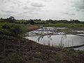 Warga menangkap ikan dalam sawah selama musim pra-panen
 -
 Balai kota dan stasiun pemancar seluler


Pranala luar
[sunting | sunting sumber]- Municipality of Quezon Diarsipkan 2007-03-12 di Wayback Machine.
- Republic Act No. 2418: An Act creating the Municipality of Quezon in the Province of Isabela
- Philippine Standard Geographic Code Diarsipkan 2012-04-13 di Wayback Machine.
- 1995 Philippine Census Information Diarsipkan 2009-08-14 di Wayback Machine.
- 2000 Philippine Census Information
- 2007 Philippine Census Information Diarsipkan 2008-11-20 di Wayback Machine.
- Local Governance Performance Management System Diarsipkan 2012-05-15 di Wayback Machine.
17°19′4.58″N 121°36′45.55″E / 17.3179389°N 121.6126528°E
| Munisipalitas | Alicia • Angadanan • Aurora • Benito Soliven • Burgos • Cabagan • Cabatuan • Cordon • Delfin Albano • Dinapigue • Divilacan • Echague • Gamu • Jones • Luna • Maconacon • Mallig • Naguilian • Palanan • Quezon • Quirino • Ramon • Reina Mercedes • Roxas • San Agustin • San Guillermo • San Isidro • San Manuel • San Mariano • San Mateo • San Pablo • Santa Maria • Santo Tomas • Tumauini |
|---|---|
| Kota komponen | |
| Kota indenpenden | Santiago (Secara administratif independen dari provinsi, namun oleh National Statistics Office dimasukkan ke Isabela) |
Artikel bertopik geografi atau tempat Filipina ini adalah sebuah rintisan. Anda dapat membantu Wikipedia dengan mengembangkannya. |