
Sète: Perbedaan antara revisi
Konten dihapus Konten ditambahkan
k r2.6.4) (bot Menambah: pms:Sète |
Wagino Bot (bicara | kontrib) k →Referensi: Bot: Merapikan artikel |
||
| (21 revisi perantara oleh 15 pengguna tidak ditampilkan) | |||
| Baris 1: | Baris 1: | ||
{{Infobox French commune |
|||
| ⚫ | |||
|name = Sète |
|||
| ⚫ | |||
|image = Pont du Tivoli, Sète, Hérault 14.jpg |
|||
|caption = Tivoli bridge |
|||
|image coat of arms = Blason ville fr Sète (Hérault).svg |
|||
|region = Languedoc-Roussillon |
|||
|department = Hérault |
|||
|arrondissement = Montpellier |
|||
|canton = Sète-1 and Sète-2 |
|||
|INSEE = 34301 |
|||
|postal code = 34200 |
|||
|demonym = Sétois |
|||
|mayor = François Commeinhes ([[Union for a Popular Movement|UMP]]) |
|||
|term = 2014–2020 |
|||
|intercommunality = Bassin de Thau |
|||
|longitude = 3.6975 |
|||
|latitude = 43.4053 |
|||
|elevation m = 4 |
|||
|elevation min m = 0 |
|||
|elevation max m = 176 |
|||
|area km2 = 24.21 |
|||
|population = 42786 |
|||
|population date = 2008 |
|||
}} |
|||
| ⚫ | |||
== Galeri == |
|||
<center> |
|||
<gallery widths="120" heights="120px" perrow="6" style="border: 0.5px solid #a86; box-shadow: 0.1em 0.1em 0.5em rgba(0,0,0,0.75); -moz-box-shadow: 0.1em 0.1em 0.5em rgba(0,0,0,0.75); -webkit-box-shadow: 0.1em 0.1em 0.5em rgba(0,0,0,0.75); border-radius: 0.5em;-moz-border-radius: 0.5em; -webkit-border-radius: 0.5em;"> |
|||
File:Phare du Mont-Saint-Clair, Sète, Hérault 05.jpg|Lighthouse of the Mount Saint-Clair |
|||
File:Théatre de la Mer à Sète.jpg|Théatre de la Mer. |
|||
File:Fort Richelieu, Sète, Hérault 03.jpg|Fort Richelieu. |
|||
File:Quai Maréchal de Lattre de Tassigny, Sète 02.jpg|Maréchal de Lattre de Tassigny Embankment. |
|||
File:Dawn on Sète and the Étang de Thau.jpg|Sète and the Étang de Thau. |
|||
File:Pont du Tivoli, Sète, Hérault 16.jpg|Tivoli Bridge over one of the canals of the town. |
|||
File:Crique de l'Anau, Sète, Hérault 01.jpg|Crique de l'Anau, a cove in the Mediterranean Sea. |
|||
File:Canal_de_la_Peyrade,_Sète,_Hérault_01.jpg|Canal de la Peyrade |
|||
</gallery> |
|||
</center> |
|||
== Referensi == |
|||
* [http://www.insee.fr/en/home/home_page.asp INSEE] |
|||
{{reflist}} |
|||
| ⚫ | |||
{{Commons|Sète}} |
{{Commons|Sète}} |
||
| ⚫ | |||
{{Authority control}} |
|||
[[Kategori:Komune di Hérault]] |
[[Kategori:Komune di Hérault]] |
||
[[Kategori:Komune di Prancis]] |
|||
| ⚫ | |||
[[bg:Сет (град)]] |
|||
[[ca:Seta]] |
|||
[[ceb:Sète]] |
|||
[[de:Sète]] |
|||
[[en:Sète]] |
|||
[[eo:Seto (franca urbo)]] |
|||
[[es:Sète]] |
|||
[[eu:Sète]] |
|||
[[fi:Sète]] |
|||
[[fr:Sète]] |
|||
[[he:סט (עיר)]] |
|||
[[it:Sète]] |
|||
[[ja:セット (エロー県)]] |
|||
[[lb:Sète]] |
|||
[[lt:Setas (Prancūzija)]] |
|||
[[ms:Sète]] |
|||
[[nl:Sète]] |
|||
[[nn:Sète]] |
|||
[[no:Sète]] |
|||
[[oc:Seta]] |
|||
[[pl:Sète]] |
|||
[[pms:Sète]] |
|||
[[pt:Sète]] |
|||
[[ro:Sète]] |
|||
[[ru:Сет (город)]] |
|||
[[sl:Sète]] |
|||
[[sv:Sète]] |
|||
[[sw:Sète]] |
|||
[[uk:Сет (місто)]] |
|||
[[vi:Sète]] |
|||
[[vo:Sète]] |
|||
[[war:Sète]] |
|||
Revisi terkini sejak 31 Agustus 2023 10.30
Sète | |
|---|---|
 Tivoli bridge | |
.svg) Lambang kebesaran | |
 Sète | |
|
Lokasi di Region Occitanie  Sète | |
| Koordinat: 43°24′19″N 3°41′51″E / 43.4053°N 3.6975°E | |
| Negara | Prancis |
| Region | Ositania |
| Departemen | Hérault |
| Arondisemen | Montpellier |
| Kanton | Sète-1 and Sète-2 |
| Antarkomune | Bassin de Thau |
| Pemerintahan | |
| • Wali kota (2014–2020) | François Commeinhes (UMP) |
| Luas | |
| • Land1 | 24,21 km2 (935 sq mi) |
| • Populasi2 | 42.786 |
| • Kepadatan Populasi2 | 18/km2 (46/sq mi) |
| Kode INSEE/pos | 34301 / 34200 |
| Ketinggian | 0–176 m (0–577 ft) (rerata 4 m or 13 ft) |
| 1 Data Pendaftaran Tanah Prancis, tak termasuk danau, kolam, gletser > 1 km² (0.386 mi² atau 247 ekar) dan muara sungai. 2 Population sans doubles comptes: penghitungan tunggal penduduk di komune lain (e.g. mahasiswa dan personil militer). | |
Sète (pengucapan bahasa Prancis: [sɛt]; Seta in Occitan) merupakan kota yang terletak di sebelah selatan Prancis. Penduduknya berjumlah 41.000 jiwa (2005).
Galeri
[sunting | sunting sumber]-
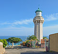 Lighthouse of the Mount Saint-Clair
 -
 Théatre de la Mer.
 -
 Fort Richelieu.
 -
 Maréchal de Lattre de Tassigny Embankment.
 -
 Sète and the Étang de Thau.
 -
 Tivoli Bridge over one of the canals of the town.
 -
 Crique de l'Anau, a cove in the Mediterranean Sea.
 -
 Canal de la Peyrade


Referensi
[sunting | sunting sumber]- lesjouteurs.com: Le Site du Pavois d'Or et des Joutes Languedociennes Diarsipkan 2016-11-02 di Wayback Machine.
Wikimedia Commons memiliki media mengenai Sète.
| Umum | |
|---|---|
| Perpustakaan nasional | |
| Lain-lain | |
Artikel bertopik geografi atau tempat Prancis ini adalah sebuah rintisan. Anda dapat membantu Wikipedia dengan mengembangkannya. |