Departemen Caazapá: Perbedaan antara revisi
Tampilan
Konten dihapus Konten ditambahkan
Tidak ada ringkasan suntingan |
k clean up, removed orphan tag using AWB |
||
| (5 revisi perantara oleh 4 pengguna tidak ditampilkan) | |||
| Baris 1: | Baris 1: | ||
{{Infobox settlement |
|||
{{kembangkan}} |
|||
| name = Caazapá |
|||
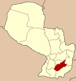
[[Berkas:Paraguay Caazapa.png|right|222px|Letak Departemen Caazapá di Paraguay]] |
|||
| native_name = |
|||
| ⚫ | |||
| native_name_lang = es<!-- ISO 639-2 code --> |
|||
| type = [[Departments of Paraguay|Department]] |
|||
| image_skyline = |
|||
| image_alt = |
|||
| image_caption = |
|||
| image_flag = Flag of Caazapá Department.svg |
|||
| flag_alt = |
|||
| image_shield = Logo de Caazapá.jpg |
|||
| shield_alt = |
|||
| nickname = |
|||
| motto = |
|||
| anthem = |
|||
| image_map = Paraguay Caazapa.png |
|||
| map_alt = |
|||
| map_caption = |
|||
| latd = 26|latm = 12|lats = |latNS = S |
|||
| longd = 56|longm = 23|longs = |longEW = W |
|||
| coor_pinpoint = |
|||
| coordinates_type = region:PY_type:adm1st |
|||
| coordinates_display = inline,title |
|||
| coordinates_footnotes = |
|||
| subdivision_type = [[List of sovereign states|Country]] |
|||
| subdivision_name = {{flag|Paraguay}} |
|||
| subdivision_type1 = Region |
|||
| subdivision_name1 = |
|||
| parts_type = Largest city |
|||
| parts_style = para |
|||
| p1 = |
|||
| established_title = [[Republic of Paraguay|Established]] |
|||
| established_date = |
|||
| blank_name_sec1 = [[Districts of Paraguay|Number of Districts]] |
|||
| blank_info_sec1 = 10 |
|||
| founder = |
|||
| named_for = |
|||
| seat_type = [[Capital (political)|Capital]] |
|||
| seat = [[Caazapá]] |
|||
| government_footnotes = |
|||
| leader_party = |
|||
| leader_title = |
|||
| leader_name = |
|||
| unit_pref = Metric<!-- or US or UK --> |
|||
| area_footnotes = |
|||
| area_total_km2 = 9496 |
|||
| area_rank = |
|||
| area_land_km2 = |
|||
| area_water_km2 = |
|||
| area_water_percent = |
|||
| area_note = |
|||
| elevation_footnotes = |
|||
| elevation_m = |
|||
| population_footnotes = |
|||
| population_total = 139241 |
|||
| population_as_of = 2002 |
|||
| population_rank = |
|||
| population_density_km2 = auto |
|||
| population_note = |
|||
| timezone1 = [[Atlantic Standard Time Zone|AST]] |
|||
| utc_offset1 = -04 |
|||
| timezone1_DST = ADT |
|||
| utc_offset1_DST = -03 |
|||
| postal_code_type = |
|||
| postal_code = |
|||
| area_code_type = |
|||
| area_code = |
|||
| iso_code = [[ISO 3166-2:PY|PY-6]] |
|||
| website = |
|||
| footnotes = |
|||
}} |
|||
| ⚫ | |||
| ⚫ | |||
== Referensi == |
|||
| ⚫ | |||
{{Reflist}} |
|||
* Illustrated Geography of Paraguay, SRL Distributed Arami, 2007. ISBN 99925-68-04-6 |
|||
* Geography of Paraguay, First Edition 1999, Publisher Hispanic Paraguay SRL |
|||
{{Geografi Paraguay}} |
|||
| ⚫ | |||
| ⚫ | |||
Revisi terkini sejak 16 November 2020 00.38
Caazapá | |
|---|---|
 | |
| Country | |
| Capital | Caazapá |
| Luas | |
| • Total | 9.496 km2 (3,666 sq mi) |
| Populasi (2002) | |
| • Total | 139.241 |
| • Kepadatan | 15/km2 (38/sq mi) |
| Zona waktu | UTC-04 (AST) |
| • Musim panas (DST) | UTC-03 (ADT) |
| Kode ISO 3166 | PY-6 |
| Number of Districts | 10 |
Caazapá (pengucapan bahasa Spanyol: [ka(a)saˈpa]) merupakan sebuah departemen di Paraguay yang memiliki luas wilayah 9.496 km² dan populasi 139.241 jiwa (2002). Ibu kotanya ialah Caazapá.
Referensi
[sunting | sunting sumber]- Illustrated Geography of Paraguay, SRL Distributed Arami, 2007. ISBN 99925-68-04-6
- Geography of Paraguay, First Edition 1999, Publisher Hispanic Paraguay SRL


