
Via Dolorosa: Perbedaan antara revisi
Membatalkan 2 suntingan oleh 180.251.151.179 (bicara): Indikasi WP:OR. Perubahan tanpa referensi. (Twinkle 🍁) |
JohnThorne (bicara | kontrib) Perbaikan |
||
| Baris 1: | Baris 1: | ||
[[File:Christ Falling on the Way to Calvary - Raphael.jpg|thumb|right|''[[Il Spasimo]]'', Yesus memanggul salib-Nya di Via Dolorosa, karya [[Raphael]], 1516]] |
|||
'''''Via Dolorosa''''' ([[bahasa Latin]] untuk "'''Jalan Kesengsaraan'''" atau "'''Jalan Penderitaan'''") adalah sebuah jalan di Kota [[Yerusalem|Yerusalem Kuno]]. Jalan ini adalah jalan yang dilalui [[Yesus]] sambil memanggl [[salib]] menuju [[Kalvari]]. |
'''''Via Dolorosa''''' ([[bahasa Latin]] untuk "'''Jalan Kesengsaraan'''" atau "'''Jalan Penderitaan'''"; bahasa Inggris: "Way of Grief," "Way of Sorrow," "Way of Suffering" atau "Painful Way"; [[bahasa Ibrani]]: ויה דולורוזה; [[bahasa Arab]]: طريق الآلام) adalah sebuah jalan di Kota [[Yerusalem|Yerusalem Kuno]]. Jalan ini diyakini adalah jalan yang dilalui [[Yesus]] sambil memanggl [[salib]] menuju [[Kalvari]]. |
||
{{Kristen-stub}} |
|||
Jalur yang berkelok-kelok dari [[benteng Antonia]] ke arah barat menuju [[Gereja Makam Kudus]]— berjarak sekitar 600 meter (2000 kaki)— menjadi tujuan utama para [[peziarah]]. Jalur yang sekarang ini ditetapkan sejak [[:en:Christianity in the 18th century|abad ke-18]], menggantikan berbagai versi sebelumnya.<ref name="Murphy O'Connor">[[Jerome Murphy-O'Connor]], ''The Holy Land'', (2008), page 37</ref> Sekarang jalan ini ditandai dengan 9 titik salib dengan lima titik salib terakhir berada di dalam [[Gereja Makam Kudus]], sehingga seluruhnya adalah 14 titik salib sejak abad ke-15.<ref name="Murphy O'Connor" /> |
|||
== Sejarah == |
|||
<!--{{Death of Jesus}}--> |
|||
<!--{{Gospel Jesus}}--> |
|||
[[File:Roman Jerusalem.PNG|thumb|right|Jalan-jalan utama – ''cardines'' (utara-selatan) dan ''decumani'' (timur-barat) – di Aelia Capitolina (=Yerusalem kuno). Via Dolorosa adalah decumanus bagian utara]] |
|||
Via Dolorosa merupakan sisa-sisa satu dari dua jalur utama timur-barat (''[[Decumanus Maximus]]'') yang melintasi [[Aelia Capitolina]], dibuat oleh kaisar [[Hadrian]]. Desain kota Romawi standar menempatkan jalur timur-barat utama melalui tengah kota, tetapi adanya [[Bait Kedua|Bait Suci]] di tengah posisi ini membuat para perancang untuk kaisar Hadrian membuat satu jalur timur-barat di sebelah utaranya. Sebagai tambahan dari jalur pusat utara-selatan (''[[cardo]]''), yang di Yerusalem mengarah ke atas bukit sebelah barat, jalur utama utara-selatan kedua ditambahkan di bawah garis [[Tyropoeon Valley]]; kedua ''cardines'' melebur di dekat [[Gerbang Damaskus]], dekat dengan Via Dolorosa. Jika Via Dolorosa diteruskan ke barat dalam garis lurus melintasi dua jalur tersebut, akan membentuk suatu [[:en:City block|blok]] segitiga yang terlalu sempit untuk membangun bangunan standar; decumanus (sekarang Via Dolorosa) sebelah barat Cardo dibangun di sebelah selatan bagian timurnya, sehingga jalur itu tidak tersambung dan terlihat sampai sekarang. |
|||
== Titik salib saat ini == |
|||
[[File:Via Dolorosa-09-.jpg|thumb|left|200px|Tanda di sepanjang Via Dolorosa, Yerusalem.]] |
|||
Jalur tradisional dimulai sedikit di dalam [[Lions' Gate]] (St. Stephen's Gate) di [[Muslim Quarter]], pada [[Umariya Elementary School]], dekat lokasi [[Benteng Antonia]] dahulu, dan mengarah ke barat melalui Kota Tua ke Gereja Makam Kudus di [[Christian Quarter]].<!-- The current enumeration is partly based on a circular devotional walk, organised by the [[Franciscans]] in the 14th century; their devotional route, heading east along the Via Dolorosa (the opposite direction to the usual westward pilgrimage), began and ended at the Church of the Holy Sepulchre, also passing through both Gethsemane and [[Mount Zion]] during its course. |
|||
Whereas the names of many roads in Jerusalem are translated into [[English language|English]], [[Hebrew language|Hebrew]], and [[Arabic language|Arabic]] for their signs, the name used in Hebrew is ''Via Dolorosa'', transliterated. The Arabic name is the translation of "way of pain." |
|||
=== Trial by Pilate: stations one and two === |
|||
[[File:'St Antonio's fortress or Monastry of Flagellation'.JPG|thumb|right|The Monastery of the Flagellation]]<!--please replace this with a picture of the "lithostratos" when there is one--><!-- |
|||
The first and second stations commemorate the events of [[Pontius Pilate#Responsibility for Jesus' death|Jesus' encounter with Pontius Pilate]], the former in memorial of the biblical account of the trial and Jesus' subsequent scourging, and the latter in memorial of the [[Ecce Homo]] speech, attributed by the [[Gospel of John]] to Pilate.<ref>{{bibleverse||John|19.5|}}</ref> On the site are three early 19th-century [[Roman Catholic]] churches, taking their names from these events; the [[Church of the Condemnation and Imposition of the Cross]], [[Church of the Flagellation]], and [[Ecce Homo (Church)|Church of Ecce Homo]]; a large area of Roman paving, beneath these structures, was traditionally regarded as the ''pavement'' ({{lang-el|lithostratos}}) described by the Bible as the location of Pilate's [[judge|judgment]] of Jesus.<ref>{{bibleverse||John|19:13|}}</ref> |
|||
[[File:Ecce IMG 1590.jpg|thumb|left|200px|The ''Ecce Homo Arch''. Originally triple-arched, it is now mostly hidden in the surrounding fabric.]] |
|||
However, scholars are now fairly certain that Pilate carried out his judgements at Herod's Palace at the southwest side of the city, rather than at this point in the city's northeast corner.<ref name="Benoit" /> [[Archaeology|Archaeological]] studies have confirmed that the Roman pavement, at these two traditional stations, was built by Hadrian as the flooring of the eastern of two [[Roman Forum|Forums]].<ref name="Benoit" /> Prior to Hadrian's changes, the area had been a large open-air pool of water, the ''[[Strouthion Pool]]'' mentioned by [[Josephus]];<ref name="Benoit" /> the pool still survives, under [[vault (architecture)|vaulting]] added by Hadrian so that the Forum could be built over it, and can be accessed from the portion of Roman paving under the [[Convent of the Sisters of Zion]], and from the [[Western Wall Tunnel]]. |
|||
Adjacent to the Church of Ecce Homo is an arch, running across the Via Dolorosa; this arch was originally the central arch of a triple-arched gateway, built by Hadrian as the main entrance to the aforementioned Forum.<ref name="Benoit" /> When later building works narrowed the Via Dolorosa, the two arches on either side of the central arch became incorporated into a succession of buildings; on the northern side, the Church of Ecce Homo now preserves the north arch; on the southern side, in the 16th century the south arch. |
|||
The three northern churches were gradually built after the site was partially acquired in 1857 by [[Marie-Alphonse Ratisbonne]], a [[Jesuit]] who intended to use it as a base for [[proselytism]] against [[Judaism]].<ref>''Encyclopedia Judaica'', Ratisbonne Brothers, Volume 13, pp.1570–1571, Keter Publishing House, Jerusalem, 1972</ref> The most recent church of the three – the Church of the Flagellation – was built during the 1920s; above the high altar, under the central dome, is a mosaic on a golden ground showing ''The Crown of Thorns Pierced by Stars'', and the church also contains modern stained-glass windows depicting ''Christ Scourged at the Pillar'', ''Pilate Washing his Hands'', and the ''Freeing of [[Barabbas]]''. The Convent, which includes the Church of Ecce Homo, was the first part of the complex to be built, and contains the most extensive archaeological remains. Prior to Ratisbonne's purchase, the site had lain in ruins for many centuries; the [[Crusades|Crusaders]] had previously constructed a set of buildings here, but they were later abandoned{{Clarify|date=May 2009}}. |
|||
=== The three Falls: stations three, seven, and nine === |
|||
[[File:Jerusalem - Via Dolorosa Station III.jpg|thumb|right|The exterior of the ''Polish Catholic Chapel'' at the third station]] |
|||
Although no such thing is recounted by the [[Biblical canon|canonical Gospels]], and no official Christian tenet makes these claims, popular tradition has it that Jesus stumbled three times during his walk along the route; this belief is currently manifested in the identification of the three stations at which these ''falls'' occurred. The tradition of the three falls appears to be a faded memory of an earlier belief in ''The Seven Falls'';<ref>''Catholic Encyclopedia'', entry on ''Way of the Cross''</ref> these were not necessarily literal ''falls'', but rather depictions of Jesus coincidentally being [[prostration|prostrate]], or nearly so, during performance of some other activity. In the (then) famous late-15th-century depiction of the ''Seven Falls'', by [[Adam Krafft]], there is only one of the ''Falls'' that is actually on the subject of Jesus stumbling under the weight of the cross, the remaining ''Falls'' being either encounters with people on the journey, the crucifixion itself, or the removal of the dead body from the cross. |
|||
[[File:Christian quarter Jerusalem Crosses.JPG|thumb|left|The ninth station, signified by the black disc on the wall. In the background you can see the entree to the Coptic Orthodox Patriarchate. The alley is parallel to the Via Dolorosa, but some way to its south]] |
|||
The first fall is represented by the current third station, located at the west end of the eastern fraction of the Via Dolorosa, adjacent to the 19th-century ''Polish Catholic Chapel''; this chapel was constructed by the [[Armenian Catholic Church|Armenian Catholics]], who though [[ethnicity|ethnically]] [[Armenia]]n, are actually based in [[Poland]]. The 1947–48 renovations, to the 19th-century chapel, were carried out with the aid of a large financial grant from the [[Polish army]]. The site was previously one of the city's [[Turkish bath]]s. |
|||
The second fall is represented by the current seventh station, located at a major crossroad junction, adjacent to a Franciscan chapel, built in 1875. In Hadrian's era, this was the junction of the main cardo (north-south road), with the decumanus (east-west road) which became the Via Dolorosa; the remains of a [[tetrapylon]], which marked this Roman junction, can be seen in the lower level of the Franciscan chapel. Prior to the 16th century, this location was the 8th and last station.<ref name="Murphy O'Connor" /> |
|||
The third fall is represented by the current ninth station, which is not actually located on the Via Dolorosa, instead being located at the entrance to the [[Ethiopian Orthodox]] Monastery and the [[Coptic Orthodox]] ''Monastery of [[Anthony the Great|Saint Anthony]]'', which together form the roof structure of the subterranean ''Chapel of Saint Helena'' in the Church of the Holy Sepulchre; the Coptic and Ethiopian Orthodox churches split in 1959, and prior to that time the monastic buildings were considered a single Monastery. However, in the early 16th century, the third fall was located at the entrance courtyard to the Church of the Holy Sepulchre, and an engraved stone cross signifying this still remains in situ. Prior to the 15th century, the final station occurred before this point would even have been reached.<ref name="Murphy O'Connor" /> |
|||
=== The Encounters === |
|||
[[File:Jerusalem Via Dolorosa BW 4.JPG|thumb|right|The [[Muristan]] in the Christian Quarter of the Old City of Jerusalem – empty by night]] |
|||
Four stations commemorate encounters between Jesus and other people, in the city streets; one encounter is mentioned in all the [[Synoptic Gospels]], one is mentioned only in the [[Gospel of Luke]], and the remaining two encounters only exist in popular tradition. |
|||
==== With Mary, Jesus' mother: fourth station ==== |
|||
The New Testament makes no mention of a meeting between Jesus and [[Mary, the mother of Jesus|his mother]], during the walk to his crucifixion, but popular tradition introduces one. The fourth station, the location of a 19th-century [[Armenian Catholic Church|Armenian Catholic]] [[oratory (worship)|oratory]], commemorates the events of this tradition; a [[lunette]], over the entrance to the chapel, references these events by means of a bas-relief carved by the [[Poland|Polish]] artist [[Zieliensky]]. The oratory, named ''Our Lady of the Spasm'', was built in 1881, but its [[crypt]] preserves some archaeological remains from former Byzantine buildings on the site, including a mosaic floor. |
|||
==== With Simon of Cyrene: fifth station ==== |
|||
{{see also|Chapel of Simon of Cyrene}} |
|||
[[File:Jerusalem Via Dolorosa BW 13.JPG|thumb|left|The exterior of the ''Chapel of Simon of Cyrene'', at the fifth station]] |
|||
The fifth station refers to the biblical episode in which [[Simon of Cyrene]] takes Jesus' cross, and carries it for him.<ref>{{bibleverse||Mark|15:21|}}</ref> Although this narrative is included in the three [[Synoptic Gospels]], the [[Gospel of John]] does not mention Simon of Cyrene<ref>{{bibleverse||John|19:17|}}</ref> but instead emphasizes the portion of the journey during which Jesus carried the cross himself.<ref>[http://thebiblestudy.co.uk/studies/simon-of-cyrene.php Simon of Cyrene – Bible Study]</ref> The current traditional site for the station is located at the east end of the western fraction of the Via Dolorosa, adjacent to the ''Chapel of Simon of Cyrene'', a Franciscan construction built in 1895. An inscription, in the [[architrave]] of one of the Chapel doors, references the Synoptic events. |
|||
Prior to the 15th century, this location was instead considered to be the ''House of the Poor Man'', and honoured as the fifth station for that reason;<ref name="Dave Winter page 126">Dave Winter, ''Israel Handbook'', page 126</ref> the name refers to the Lukan tale of [[Lazarus and Dives]],<ref>{{bibleverse||Luke|16:19–31|}}</ref> this Lazarus being a beggar, and ''Dives'' being the Latin word for ''[one who is] Rich''. Adjacent to the alleged ''House of the Poor Man'' is an arch over the road; the house on the arch was thought to be the corresponding ''House of the Rich Man''.<ref name="Dave Winter page 126" /> The houses in question, however, only date to the Middle Ages,<ref>''Catholic Encyclopedia'', entry for ''Dives''</ref> and the narrative of Lazarus and Dives is now widely held to be a [[parable]].<ref>''The IVP Bible Background Commentary''</ref><ref>[[N. T. Wright]], ''Luke for Everyone''</ref><ref>[[Joachim Jeremias]], ''The Parables of Jesus''</ref> |
|||
==== With Veronica: sixth station ==== |
|||
A medieval Roman Catholic legend viewed a specific piece of cloth, known as the ''[[Veil of Veronica]]'', as having been supernaturally imprinted with Jesus' image, by physical contact with Jesus' face. By [[Metathesis (linguistics)|metathesis]] of the [[Latin]] words ''vera icon'' (meaning ''true image'') into ''Veronica'',<ref>[[Catholic Encyclopedia]], ''St. Veronica''</ref> it came to be said that the ''Veil of Veronica'' had gained its image when a ''[[Saint Veronica]]'' encountered Jesus, and wiped the sweat from his face with the cloth; no element of this legend is present in the bible, although the similar ''[[Image of Edessa]]'' is mentioned in ''The Epistles of Jesus Christ and Abgarus King of Edessa'', a late piece of [[New Testament apocrypha]]. The ''Veil of Veronica'' relates to a pre-Crucifixion image, and is distinct from the post-Crucifixion [[Holy Face]] image, often related to the [[Shroud of Turin]]. |
|||
The current sixth station of the Via Dolorosa commemorates this legendary encounter between Jesus and Veronica. The location was identified as the site of the encounter in the 19th century; in 1883, Greek Roman Catholics purchased the 12th-century ruins at the location, and built the ''Church of the Holy Face and Saint Veronica'' on them, claiming that Veronica had encountered Jesus outside her own house, and that the house had formerly been positioned at this spot. The church includes some of the remains of the 12th-century buildings which had formerly been on the site, including arches from the Crusader-built ''Monastery of [[Saints Cosmas and Damian|Saint Cosmas]]''. The present building is administered by the ''[[Little Sisters of Jesus]]'', and is not generally open to the public.<ref>{{cite book |chapterurl=https://books.google.co.uk/books?id=X0jH6VPi4-gC&pg=PA160&lpg=PA160&dq=Monastery+of+Saint+Cosmas+jerusalem&source=bl&ots=bkshGftsPf&sig=5EP8e94GvQ07tUff9L9urAxmzFw&hl=en&sa=X&ved=0ahUKEwjJm7_Z6cPOAhXjJ5oKHZbfDIIQ6AEIPTAF#v=onepage&q=Monastery%20of%20Saint%20Cosmas%20jerusalem&f=false |title=The Churches of the Crusader Kingdom of Jerusalem: Volume 3, The City of Jerusalem |first=Denys |last=Pringle |date=28 June 2007 |chapter=Church of St Cosmas |page=160 |publisher=[[Cambridge University Press]] |isbn=978-0521390385 |accessdate=15 August 2016}}</ref> |
|||
[[File:Assisi frescoes detail pietro lorenzetti 2.jpg|thumb|left|[[Pietro Lorenzetti]]'s [[fresco]] of women following Jesus on Via Dolorosa, [[Assisi]], 1320]] |
|||
==== With Pious Women: eighth station ==== |
|||
[[File:Israel 5 010 Via Dolorosa- Walk in Jerusalem, with Jesus Christ-Actor and Press.jpg|thumb|right|200px|Reenacting the Stations of the Cross on Via Dolorosa]] |
|||
The Eighth station commemorates an episode described by the [[Gospel of Luke]], alone among the canonical gospels, in which Jesus encounters ''pious women'' on his journey, and is able to stop and give a sermon.<ref>{{bibleverse||Luke|23:27–31|}}</ref> However, prior to the 15th century the final station in Jesus' walk was believed to occur at a point earlier on the Via Dolorosa, before this location would have been reached. The present eighth station is adjacent to the [[Greek Orthodox]] ''Monastery of Saint [[Charalampus]]''; it is marked by the word ''Nika'' (a [[Greek language|Greek]] word meaning ''Victory'') carved into the wall, and an embossed cross. |
|||
== Modern processions == |
|||
Each Friday, a Roman Catholic procession walks the Via Dolorosa route, starting out at the monastic complex by the first station; the procession is organized by the Franciscans of this monastery, who also lead the procession. Acted re-enactments also regularly take place on the route, ranging from amateur productions with, for example, soldiers wearing plastic helmets and vivid red polyester wraps, to more professional drama with historically accurate clothing and props.<ref>''Jerusalem of the Heavens: The Eternal City in Bird's Eye View'' by |
|||
Yehuda Salomon, Mosheh Milner 1993 ISBN 965-474-000-1 page 187</ref><ref>''Frommer's Jerusalem Day by Day'' by Buzzy Gordon 2010 ISBN 0-470-67636-1 page 12</ref><ref>''Frommer's Israel'' by Robert Ullian 2010 ISBN 0-470-61820-5 page 179</ref> |
|||
The seat of the Coptic Orthodox Patriarchate in Jerusalem is located on the roof of the Church of the Holy Sepulchre. At the entrance of the Patriarchate is a column with a cross on it, marking the 9th Station of the Via Dolorosa.<ref>[https://sites.google.com/site/copticorthodoxjerusalem//our-church-in-jerusalem "The Coptic Church in Jerusalem", Coptic Orthodox Patriarchate, Jerusalem]</ref> In 1980 [[Pope Shenouda III of Alexandria]] (3 August 1923 – 17 March 2012) had forbidden Coptic faithful from traveling to Jerusalem on pilgrimage until the Israeli-Palestinian conflict was resolved. However, despite the ban, dozens of Coptic pilgrims travel to Jerusalem every year, especially during the Easter holidays.<ref>[http://english.al-akhbar.com/node/6404 Kissab, Bisan. "Coptic Church: No Pilgrimage to Jerusalem Before Liberation", ''Al-Akhbar'', April 20, 2012]</ref> |
|||
--> |
|||
== Galeri == |
|||
<!-- The images are selected from Common's best/good images of Via Dolorosa (Church of the Holy Sepulchre, Jerusalem). Do not add irrelevant images. Stations of the Cross as as per Traditional form --> |
|||
<gallery> |
|||
Geisselungskapelle BW 1.JPG|Titik salib pertama, Yesus dijatuhi hukuman mati |
|||
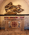
Sculpture at Church of the Condemnation and Imposition of the Cross.JPG|Titik salib ke-2, Yesus memanggul salib-Nya |
|||
Chapel in 3rd Station (Via Dolorosa).JPG|Titik salib ke-3, Yesus jatuh pertama kalinya |
|||
Chapel in 4th Station (Via Dolorosa).JPG|Titik salib ke-4, Yesus berjumpa dengan ibu-Nya |
|||
Chapel in 5th Station (Via Dolorosa).JPG|Titik salib ke-5, Simon orang Kirene membantu Yesus memanggul salib |
|||
Chapel in 6th Station (Via Dolorosa).JPG|Titik salib ke-6, Veronica mengusap wajah Jesus |
|||
Chapel in 7th Station (Via Dolorosa).JPG|Titik salib ke-7, Yesus jatuh kedua kalinya |
|||
Israel - Jerusalem - The Old City - 117 (4260903445).jpg|Titik salib ke-8, Yesus bertemu para perempuan Yerusalem |
|||
Jerusalem Holy Sepulchre BW 22.JPG|Titik salib ke-9, Yesus jatuh ketiga kalinya |
|||
Israel Batch 1 (888).JPG|Titik salib ke-10, Pakaian Yesus diambil daripada-Nya |
|||
Holy Sepulchre1.jpg|Titik salib ke-11, Penyaliban: Yesus dipaku pada kayu salib |
|||
Голгофа.jpg|Titik salib ke-12, Yesus mati pada kayu salib |
|||
5277-20080123-jerusalem-stone-of-anointing.jpg|Batu pengurapan |
|||
Jerusalem Grabeskirche Innen Grab Jesu 2.JPG|Titik salib ke-14, Yesus dibaringkan di dalam kubur |
|||
</gallery> |
|||
== Referensi == |
|||
{{reflist}} |
|||
[[Kategori:Yerusalem]] |
[[Kategori:Yerusalem]] |
||
Revisi per 9 Juni 2017 23.34

Via Dolorosa (bahasa Latin untuk "Jalan Kesengsaraan" atau "Jalan Penderitaan"; bahasa Inggris: "Way of Grief," "Way of Sorrow," "Way of Suffering" atau "Painful Way"; bahasa Ibrani: ויה דולורוזה; bahasa Arab: طريق الآلام) adalah sebuah jalan di Kota Yerusalem Kuno. Jalan ini diyakini adalah jalan yang dilalui Yesus sambil memanggl salib menuju Kalvari.
Jalur yang berkelok-kelok dari benteng Antonia ke arah barat menuju Gereja Makam Kudus— berjarak sekitar 600 meter (2000 kaki)— menjadi tujuan utama para peziarah. Jalur yang sekarang ini ditetapkan sejak abad ke-18, menggantikan berbagai versi sebelumnya.[1] Sekarang jalan ini ditandai dengan 9 titik salib dengan lima titik salib terakhir berada di dalam Gereja Makam Kudus, sehingga seluruhnya adalah 14 titik salib sejak abad ke-15.[1]
Sejarah

Via Dolorosa merupakan sisa-sisa satu dari dua jalur utama timur-barat (Decumanus Maximus) yang melintasi Aelia Capitolina, dibuat oleh kaisar Hadrian. Desain kota Romawi standar menempatkan jalur timur-barat utama melalui tengah kota, tetapi adanya Bait Suci di tengah posisi ini membuat para perancang untuk kaisar Hadrian membuat satu jalur timur-barat di sebelah utaranya. Sebagai tambahan dari jalur pusat utara-selatan (cardo), yang di Yerusalem mengarah ke atas bukit sebelah barat, jalur utama utara-selatan kedua ditambahkan di bawah garis Tyropoeon Valley; kedua cardines melebur di dekat Gerbang Damaskus, dekat dengan Via Dolorosa. Jika Via Dolorosa diteruskan ke barat dalam garis lurus melintasi dua jalur tersebut, akan membentuk suatu blok segitiga yang terlalu sempit untuk membangun bangunan standar; decumanus (sekarang Via Dolorosa) sebelah barat Cardo dibangun di sebelah selatan bagian timurnya, sehingga jalur itu tidak tersambung dan terlihat sampai sekarang.
Titik salib saat ini

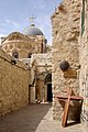
Jalur tradisional dimulai sedikit di dalam Lions' Gate (St. Stephen's Gate) di Muslim Quarter, pada Umariya Elementary School, dekat lokasi Benteng Antonia dahulu, dan mengarah ke barat melalui Kota Tua ke Gereja Makam Kudus di Christian Quarter.
Galeri
-
 Titik salib pertama, Yesus dijatuhi hukuman mati
 -
 Titik salib ke-2, Yesus memanggul salib-Nya
 -
 Titik salib ke-3, Yesus jatuh pertama kalinya
 -
 Titik salib ke-4, Yesus berjumpa dengan ibu-Nya
 -
 Titik salib ke-5, Simon orang Kirene membantu Yesus memanggul salib
 -
 Titik salib ke-6, Veronica mengusap wajah Jesus
 -
 Titik salib ke-7, Yesus jatuh kedua kalinya
 -
 Titik salib ke-8, Yesus bertemu para perempuan Yerusalem
 -
 Titik salib ke-9, Yesus jatuh ketiga kalinya
 -
 Titik salib ke-10, Pakaian Yesus diambil daripada-Nya
 -
 Titik salib ke-11, Penyaliban: Yesus dipaku pada kayu salib
 -
 Titik salib ke-12, Yesus mati pada kayu salib
 -
 Batu pengurapan
 -
 Titik salib ke-14, Yesus dibaringkan di dalam kubur


.JPG)
.JPG)
.JPG)
.JPG)
.JPG)
.jpg)

.jpg)


Referensi
- ^ a b Jerome Murphy-O'Connor, The Holy Land, (2008), page 37