Shaftesbury: Perbedaan antara revisi
Tampilan
Konten dihapus Konten ditambahkan
Rachmat-bot (bicara | kontrib) k tidy up |
Tidak ada ringkasan suntingan |
||
| Baris 1: | Baris 1: | ||
{{Infobox UK place |
|||
{{kembangkan}} |
|||
| official_name= Shaftesbury |
|||
| ⚫ | |||
| local_name= |
|||
| shire_district= [[North Dorset]] |
|||
| shire_county= [[Dorset]] |
|||
| country= England |
|||
| region= South West England |
|||
| static_image_name= High Street, Shaftesbury - geograph.org.uk - 1440129.jpg |
|||
| static_image_caption= High Street |
|||
| population = 7314 |
|||
| population_ref = <ref name=ons>{{cite web |url=http://www.neighbourhood.statistics.gov.uk/dissemination/LeadKeyFigures.do?a=7&b=11128341&c=Shaftesbury&d=16&e=62&g=6418052&i=1001x1003x1032x1004&o=362&m=0&r=1&s=1433061124578&enc=1 |title=Area: Shaftesbury (Parish). Key Figures for 2011 Census: Key Statistics |publisher=Office for National Statistics |work=Neighbourhood Statistics |accessdate=6 February 2015}}</ref> |
|||
| os_grid_reference= ST861228 |
|||
| map_type= Dorset |
|||
| latitude= 51.0059 |
|||
| longitude= -2.1969 |
|||
| london_distance= |
|||
| post_town= SHAFTESBURY |
|||
| postcode_area= SP |
|||
| postcode_district= SP7 |
|||
| dial_code= 01747 |
|||
| constituency_westminster= [[North Dorset (constituency)|North Dorset]] |
|||
}} |
|||
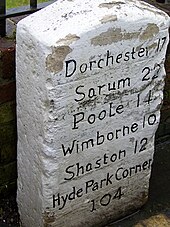
[[File:Milestone, Blandford Forum - geograph.org.uk - 1714569.jpg|thumb|upright|Old milestone in [[Blandford Forum]] showing use of the name Shaston for Shaftesbury]] |
|||
| ⚫ | |||
| ⚫ | |||
==Referensi== |
|||
===Notes=== |
|||
{{Reflist|30em}} |
|||
===General references=== |
|||
* {{cite book |title=Dorset |author=J. H. Bettey |series=City & County Histories |year=1974 |publisher=David & Charles |ISBN=0-7153-6371-9}} |
|||
* Pitt-Rivers, Michael, 1979. ''Dorset''. London: Faber & Faber. |
|||
* The 1985 AA illustrated guide to the country towns and villages of Britain. |
|||
| ⚫ | |||
{{Inggris-geo-stub}} |
{{Inggris-geo-stub}} |
||
Revisi per 13 Maret 2016 09.02
51°00′21″N 2°11′49″W / 51.0059°N 2.1969°W
| Shaftesbury | |
 High Street |
|
| Population | 7.314 [1] |
|---|---|
| Ref. grid OS | ST861228 |
| Distrik | North Dorset |
| County shire | Dorset |
| Region | South West |
| Negara konstituen | England |
| Negara berdaulat | Britania Raya |
| Kota pos | SHAFTESBURY |
| Distrik kode pos | SP7 |
| Kode telepon | 01747 |
| Polisi | |
| Pemadam kebakaran | |
| Ambulans | |
| Parlemen UE | |
| Parlemen Britania Raya | North Dorset |
| Daftar tempat: Britania Raya | |

Shaftesbury /ˈʃɑːftsbəri/ adalah sebuah kota di Dorset Utara, Inggris. Kota itu dibangun 718 kaki di atas laut. Kota ini merupakan salah satu kota tertua dan tertinggi di Inggris.
Referensi
Notes
- ^ "Area: Shaftesbury (Parish). Key Figures for 2011 Census: Key Statistics". Neighbourhood Statistics. Office for National Statistics. Diakses tanggal 6 February 2015.
General references
- J. H. Bettey (1974). Dorset. City & County Histories. David & Charles. ISBN 0-7153-6371-9.
- Pitt-Rivers, Michael, 1979. Dorset. London: Faber & Faber.
- The 1985 AA illustrated guide to the country towns and villages of Britain.

