Ma'ale HaShalom: Perbedaan antara revisi
kTidak ada ringkasan suntingan Tag: VisualEditor Suntingan perangkat seluler Suntingan peramban seluler |
k Bot: Perubahan kosmetika |
||
| Baris 1: | Baris 1: | ||
[[ |
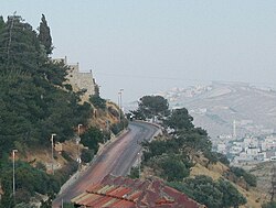
[[Berkas:Pope's Road leading up to Mount Zion.jpg|jmpl|ka|250px|Ma'ale HaShalom, menaiki Bukit Sion]] |
||
'''Ma'ale ha-Shalom''' (Ibrani: מעלה השלום, diterjemahkan menjadi'' Pendakian Damai''), juga dikenal sebagai '''Jalan Paus''' (Ibrani: כביש האַפִּיפְיוֹר, ''Kevish ha-Apifior''), adalah sebuah jalan di [[Jerusalem|Yerusalem]], [[Palestina]]. |
'''Ma'ale ha-Shalom''' (Ibrani: מעלה השלום, diterjemahkan menjadi'' Pendakian Damai''), juga dikenal sebagai '''Jalan Paus''' (Ibrani: כביש האַפִּיפְיוֹר, ''Kevish ha-Apifior''), adalah sebuah jalan di [[Jerusalem|Yerusalem]], [[Palestina]]. |
||
Ma'ale HaShalom menghubungkan [[Highway 60 (Israel)|Rute 60]] ke [[Ma'alot Ir David]] menjadi Derech ha-Ofel. Jalan ini membentang di sepanjang selatan tembok [[Kota Lama Yerusalem|Kota Lama]] dan memiliki [[Gerbang Dung]] yang menjadi pintu masuk menuju ke [[Bagian Yahudi (Yerusalem)|Bagian Yahudi]]. Jalan ini juga melewati [[Pemakaman Bukit Sion Protestan]] dan Kuburan Katolik serta paralel dengan [[Bukit Bait]].<ref group = map> |
Ma'ale HaShalom menghubungkan [[Highway 60 (Israel)|Rute 60]] ke [[Ma'alot Ir David]] menjadi Derech ha-Ofel. Jalan ini membentang di sepanjang selatan tembok [[Kota Lama Yerusalem|Kota Lama]] dan memiliki [[Gerbang Dung]] yang menjadi pintu masuk menuju ke [[Bagian Yahudi (Yerusalem)|Bagian Yahudi]]. Jalan ini juga melewati [[Pemakaman Bukit Sion Protestan]] dan Kuburan Katolik serta paralel dengan [[Bukit Bait]].<ref group = map> |
||
| Baris 15: | Baris 15: | ||
Sebelum [[Perang Enam Hari]], jalan ini dikenal sebagai Ain el-Loza.<ref>[http://www.poica.org/editor/case_studies/view.php?recordID=1479 Israel falsely rewrites the Hostoric Identity of the Occupied Palestinian Territory] {{webarchive|url=https://web.archive.org/web/20120614142445/http://www.poica.org/editor/case_studies/view.php?recordID=1479 |date=2012-06-14 }}, [[Applied Research Institute–Jerusalem]]</ref>{{Verify credibility|date=May 2011}} |
Sebelum [[Perang Enam Hari]], jalan ini dikenal sebagai Ain el-Loza.<ref>[http://www.poica.org/editor/case_studies/view.php?recordID=1479 Israel falsely rewrites the Hostoric Identity of the Occupied Palestinian Territory] {{webarchive|url=https://web.archive.org/web/20120614142445/http://www.poica.org/editor/case_studies/view.php?recordID=1479 |date=2012-06-14 }}, [[Applied Research Institute–Jerusalem]]</ref>{{Verify credibility|date=May 2011}} |
||
==Rujukan== |
== Rujukan == |
||
{{Reflist | refs = |
{{Reflist | refs = |
||
<!-- <ref name = JMunicipality> |
<!-- <ref name = JMunicipality> |
||
| Baris 47: | Baris 47: | ||
}} |
}} |
||
==Bacaan lanjut== |
== Bacaan lanjut == |
||
*{{cite news |
* {{cite news |
||
| title = Night Vision (Article number - 824580) |
| title = Night Vision (Article number - 824580) |
||
| author = Rosenblum Irit |
| author = Rosenblum Irit |
||
| Baris 55: | Baris 55: | ||
| quote = ...on foot from Absalom's Monument to Ma'ale Hashalom, which is lit as far as the Western Wall. |
| quote = ...on foot from Absalom's Monument to Ma'ale Hashalom, which is lit as far as the Western Wall. |
||
}} |
}} |
||
*{{cite book |
* {{cite book |
||
| author = Ronald L. Eisenberg |
| author = Ronald L. Eisenberg |
||
| title = The streets of Jerusalem: who, what, why |
| title = The streets of Jerusalem: who, what, why |
||
| Baris 75: | Baris 75: | ||
{{DEFAULTSORT:Ma'ale Hashalom}} |
{{DEFAULTSORT:Ma'ale Hashalom}} |
||
[[ |
[[Kategori:Streets in Jerusalem]] |
||
[[ |
[[Kategori:Mount Zion]] |
||
[[ |
[[Kategori:Jordanian construction in eastern Jerusalem]] |
||
Revisi terkini sejak 14 Februari 2019 11.34

Ma'ale ha-Shalom (Ibrani: מעלה השלום, diterjemahkan menjadi Pendakian Damai), juga dikenal sebagai Jalan Paus (Ibrani: כביש האַפִּיפְיוֹר, Kevish ha-Apifior), adalah sebuah jalan di Yerusalem, Palestina.
Ma'ale HaShalom menghubungkan Rute 60 ke Ma'alot Ir David menjadi Derech ha-Ofel. Jalan ini membentang di sepanjang selatan tembok Kota Lama dan memiliki Gerbang Dung yang menjadi pintu masuk menuju ke Bagian Yahudi. Jalan ini juga melewati Pemakaman Bukit Sion Protestan dan Kuburan Katolik serta paralel dengan Bukit Bait.[map 1] Meskipun di luar tembok kota lama hari ini, jalan itu dianggap berada di dalam kota Yerusalem yang disucikan.
Sebelum 1964, jalan menuju Gunung Sion adalah jalan tanah yang sempit. Tahun itu, Paus Paulus VI berencana untuk mengunjungi Yerusalem dan untuk menghormatinya, orang-orang Yordania mengizinkan pelebaran dan peletakan jalan yang tepat untuk memungkinkan Paus dibawa ke Coenaculum.[1][2][3][4]
Sebelum Perang Enam Hari, jalan ini dikenal sebagai Ain el-Loza.[5][sumber tepercaya?]
Rujukan
[sunting | sunting sumber]- ^ Uzi Narkiss (1983). The liberation of Jerusalem: the battle of 1967. Vallentine, Mitchell. hlm. 34. ISBN 978-0-85303-209-0. Diakses tanggal 23 June 2011.
The way to Mount Zion was a narrow dirt-track. While preparations were under way for the visit of Pope Paul VI to Jerusalem in January 1964, therefore, it was decided to widen the path and lay a proper road. The Pope had expressed a wish to pray at the Coenaculum; an improved road would make his journey more comfortable. The Jordanians did not object and the road was laid to within about 60 meters of the Coenaculum.
- ^ John M. Oesterreicher; Anne Sinai (1974). Jerusalem. John Day. hlm. 27. ISBN 978-0-381-98266-9. Diakses tanggal 23 June 2011.
He ascended Mt. Zion to the Coenaculum, the hall in which the Last Supper had taken place, on a new road which had been constructed in his honor.
- ^ Aviva Bar-Am; Gershon Rechtman (1 December 1999). Jerusalem easywalks. Ingeborg Rennet Center for Jerusalem Studies. hlm. 13. ISBN 978-965-90048-6-7. Diakses tanggal 23 June 2011.
In 1964 Pope Paul VI visited Mount Zion. The road that winds around the right side of the mountain was built especially for the car that drove him to Dormition Abbey and to the Cenacle — site of the Last Supper.
- ^ Nagel Publishers (1969). Israel. Nagel. hlm. 216. Diakses tanggal 23 June 2011.
It can be reached by car on the "Pope's Road", built in 1964 on the occasion of his visit.
- ^ Israel falsely rewrites the Hostoric Identity of the Occupied Palestinian Territory Diarsipkan 2012-06-14 di Wayback Machine., Applied Research Institute–Jerusalem
Bacaan lanjut
[sunting | sunting sumber]- Rosenblum Irit (5 August 1998). "Night Vision (Article number - 824580)". Haaretz Archive.
...on foot from Absalom's Monument to Ma'ale Hashalom, which is lit as far as the Western Wall.
- Ronald L. Eisenberg (October 2006). The streets of Jerusalem: who, what, why. Devora Publishing. hlm. 240. ISBN 978-1-932687-54-5. Diakses tanggal 2011-06-25.
Ma'aleh Hashalom (peace), symbolic name for the Dung Gate, with the hope that it should change from being a place to hurl refuse to a gate of peace.
Foto udara dan peta
[sunting | sunting sumber]- ^ Peta Google – Ma'ale Ha-Shalom, Jerusalem (Peta). Kartografi oleh Google, Inc. Google, Inc. Diakses tanggal 2011-06-28.

