Zaanstad: Perbedaan antara revisi
Tampilan
Konten dihapus Konten ditambahkan
+ |
Angayubagia (bicara | kontrib) kTidak ada ringkasan suntingan Tag: Suntingan visualeditor-wikitext |
||
| Baris 1: | Baris 1: | ||
{{Infobox settlement |
|||
{{tambah infobox|geo-Belanda}} |
|||
<!-- See Template:Infobox settlement for additional fields and descriptions --> |
|||
<!-- Name and transliteration --> |
|||
| name = Zaanstad |
|||
| settlement_type = [[Daftar kota di Belanda|Munisipalitas]] |
|||
<!-- Images, nickname, motto --> |
|||
| image_skyline = Windmill Het Pink Zaanstad.jpg |
|||
| image_alt = |
|||
| image_caption = Windmill {{ill|Het Pink|nl}} |
|||
| image_flag = Flag of Zaanstad.svg |
|||
| flag_size = 100px |
|||
| flag_alt = |
|||
| image_shield = Coat of arms of Zaanstad.svg |
|||
| shield_size = 100px |
|||
| shield_alt = |
|||
<!-- Maps, coordinates --> |
|||
| image_map = Map - NL - Municipality code 0479 (2009).svg |
|||
| map_alt = Posisi yang disorot dari Zaanstad di peta kota di Belanda Utara |
|||
| map_caption = Lokasi di Holland Utara |
|||
| coordinates = {{coord|52|26|N|4|49|E|region:NL|display=inline,title}} |
|||
| coordinates_footnotes = |
|||
| subdivision_type = [[Daftar negara berdaulat|Negara]] |
|||
| subdivision_name = [[Belanda]] |
|||
| subdivision_type1 = [[Provinsi di Belanda|Provinsi]] |
|||
| subdivision_name1 = [[Holland Utara]] |
|||
| established_title = Tanggal didirikan |
|||
| established_date = 1 Januari 1974 |
|||
| government_footnotes = <ref name="mayor_now">{{cite web |
|||
|url = https://www.zaanstad.nl/mozard/!suite86.scherm0325?mPag=251&mVrg=873&mLok=1 |
|||
|title = Burgemeester mr. G.H. Faber (PvdA) |
|||
|trans-title = Mayor G.H. Faber (PvdA) |
|||
|language = nl |
|||
|publisher = Gemeente Zaanstad |
|||
|access-date = 6 March 2014}}</ref> |
|||
| governing_body = [[Dewan kota (Belanda)|Dewan kota]] |
|||
| leader_party = [[Partai Buruh (Belanda)|PvdA]] |
|||
| leader_title = [[Burgemeester|Mayor]] |
|||
| leader_name = [[Jan Hamming]] |
|||
<!-- Geographic information --> |
|||
| unit_pref = Metric |
|||
<!-- ALL fields with measurements have automatic unit conversion --> |
|||
<!-- for references: use <ref> tags --> |
|||
| area_footnotes = <ref>{{Dutch municipality total area|dataref}}</ref> |
|||
<!-- square kilometers --> |
|||
| area_total_km2 = {{Dutch municipality total area|Zaanstad}} |
|||
| area_land_km2 = {{Dutch municipality land area|Zaanstad}} |
|||
| area_water_km2 = {{Dutch municipality water area|Zaanstad}} |
|||
| elevation_footnotes = <ref name="AHN">{{cite web |
|||
|url = http://www.ahn.nl/postcodetool |
|||
|title = Postcodetool for 1506MZ |
|||
|language = nl |
|||
|author = <!--Staff writer(s); no by-line.--> |
|||
|work = Actueel Hoogtebestand Nederland |
|||
|publisher = Het Waterschapshuis |
|||
|access-date = 6 March 2014}}</ref> |
|||
| elevation_m = 1 |
|||
| elevation_min_m = |
|||
<!-- Population, demographics --> |
|||
| elevation_max_footnotes = <!-- for references: use <ref> tags --> |
|||
| elevation_min_footnotes = <!-- for references: use <ref> tags --> |
|||
| population_total = {{Dutch municipality population|Zaanstad}} |
|||
| population_as_of = {{MONTHNAME|{{Dutch municipality population|popbasemonth}}}} {{Dutch municipality population|popbaseyear}} |
|||
| population_footnotes = <ref>{{Dutch municipality population|dataref}}</ref> |
|||
| population_density_km2 = {{Dutch municipality population density|Zaanstad}} <!-- For automatic calculation: auto--> |
|||
| population_demonym = |
|||
<!-- Other information --> |
|||
| postal_code_type = [[Kode pos di Belanda|Kode pos]] |
|||
| postal_code = Bagian dari kisaran 1500 |
|||
| area_code = 075 |
|||
| area_code_type = [[Nomor telepon di Belanda|Kode area]] |
|||
| website = {{URL|1=http://www.zaanstad.nl}} |
|||
| footnotes = |
|||
| elevation_max_m = |
|||
| timezone = [[Waktu Eropa Tengah|CET]] |
|||
| utc_offset = +1 |
|||
| timezone_DST = [[Waktu Musim Panas Eropa Tengah|CEST]] |
|||
| utc_offset_DST = +2 |
|||
}} |
|||
[[Berkas:LocatieZaanstad.png|ka]] |
[[Berkas:LocatieZaanstad.png|ka]] |
||
Revisi per 30 Maret 2021 06.04
Zaanstad | |
|---|---|
![Windmill Het Pink [nl]](http://upload.wikimedia.org/wikipedia/commons/thumb/8/87/Windmill_Het_Pink_Zaanstad.jpg/250px-Windmill_Het_Pink_Zaanstad.jpg) Windmill Het Pink | |
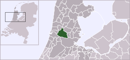
 Lokasi di Holland Utara | |
| Koordinat: 52°26′N 4°49′E / 52.433°N 4.817°E | |
| Negara | Belanda |
| Provinsi | Holland Utara |
| Tanggal didirikan | 1 Januari 1974 |
| Pemerintahan | |
| • Badan | Dewan kota |
| • Mayor | Jan Hamming (PvdA) |
| Luas | |
| • Total | data missing km2 (Formatting error: invalid input when rounding sq mi) |
| • Luas daratan | data missing km2 (Formatting error: invalid input when rounding sq mi) |
| • Luas perairan | Galat Lua: . km2 (Formatting error: invalid input when rounding sq mi) |
| Ketinggian | 1 m (3 ft) |
| Populasi (Mei 2014)[4] | |
| • Total | data missing |
| Zona waktu | UTC+1 (CET) |
| • Musim panas (DST) | UTC+2 (CEST) |
| Kode pos | Bagian dari kisaran 1500 |
| Kode area telepon | 075 |
| Situs web | www |

Zaanstad adalah sebuah gemeente Belanda yang terletak di provinsi Holland Utara. Pada tahun 2019 daerah ini memiliki penduduk sebesar 155.885 jiwa.
Tempat terpenting adalah Zaandam.
Daerah ini berada persis di utara Amsterdam, ibu kota Belanda.
Lihat pula
- ^ "Burgemeester mr. G.H. Faber (PvdA)" [Mayor G.H. Faber (PvdA)] (dalam bahasa Belanda). Gemeente Zaanstad. Diakses tanggal 6 March 2014.
- ^ "Kerncijfers wijken en buurten 2020" [Key figures for neighbourhoods 2020]. StatLine (dalam bahasa Belanda). CBS. 24 July 2020. Diakses tanggal 19 September 2020.
- ^ "Postcodetool for 1506MZ". Actueel Hoogtebestand Nederland (dalam bahasa Belanda). Het Waterschapshuis. Diakses tanggal 6 March 2014.
- ^ "Bevolkingsontwikkeling; regio per maand". CBS Statline (dalam bahasa Dutch). CBS. 26 June 2014. Diakses tanggal 24 July 2014.


