Pulau Taiping: Perbedaan antara revisi
Tampilan
Konten dihapus Konten ditambahkan
k clean up |
Rescuing 1 sources and tagging 0 as dead.) #IABot (v2.0.8.1 |
||
| Baris 46: | Baris 46: | ||
}} |
}} |
||
'''Pulau Taiping''', juga dikenal sebagai '''Itu Aba''', dan berbagai nama lainnya, adalah sebuah pulau terbesar di [[Kepulauan Spratly]], [[Laut Tiongkok Selatan]].<ref>C. Michael Hogan (2011) [http://www.eoearth.org/article/South_China_Sea?topic=49523 ''South China Sea'' Topic ed. P.Saundry. Ed.-in-chief C.J.Cleveland. Encyclopedia of Earth. National Council for Science and the Environment. Washington DC]</ref><ref>{{cite web |title = Taiping Island |url = http://marine.cpami.gov.tw/english/index.php?option=com_content&view=article&id=289&Itemid=161 |work = Spratly islands |publisher = Marine National Park Headquarters (Republic of China) |access-date = 21 March 2014 }}</ref><ref>{{cite news |title = Itu Aba – Inquirer Global Nation |url = http://globalnation.inquirer.net/109656/in-the-know-itu-aba |newspaper = Philippine Daily Inquirer |access-date = 19 Aug 2014 }}</ref><ref>{{cite news |title = Taiwan Considers Permanent Armed Ships For Disputed South China Sea Island |url = http://uk.reuters.com/article/2014/10/16/uk-taiwan-soutchinasea-idUKKCN0I509O20141016 |agency = Reuters |author = Michael Gold |access-date = 16 Oct 2014 }}</ref> Pulau tersebut memiliki panjang {{convert|1.4|km|mi}} dan lebar {{convert|0.4|km|mi}}, dengan luas {{convert|46|ha|acres}}. |
'''Pulau Taiping''', juga dikenal sebagai '''Itu Aba''', dan berbagai nama lainnya, adalah sebuah pulau terbesar di [[Kepulauan Spratly]], [[Laut Tiongkok Selatan]].<ref>C. Michael Hogan (2011) [http://www.eoearth.org/article/South_China_Sea?topic=49523 ''South China Sea'' Topic ed. P.Saundry. Ed.-in-chief C.J.Cleveland. Encyclopedia of Earth. National Council for Science and the Environment. Washington DC]</ref><ref>{{cite web |title = Taiping Island |url = http://marine.cpami.gov.tw/english/index.php?option=com_content&view=article&id=289&Itemid=161 |work = Spratly islands |publisher = Marine National Park Headquarters (Republic of China) |access-date = 21 March 2014 }}</ref><ref>{{cite news |title = Itu Aba – Inquirer Global Nation |url = http://globalnation.inquirer.net/109656/in-the-know-itu-aba |newspaper = Philippine Daily Inquirer |access-date = 19 Aug 2014 }}</ref><ref>{{cite news |title = Taiwan Considers Permanent Armed Ships For Disputed South China Sea Island |url = http://uk.reuters.com/article/2014/10/16/uk-taiwan-soutchinasea-idUKKCN0I509O20141016 |agency = Reuters |author = Michael Gold |access-date = 16 Oct 2014 |archive-date = 2014-10-19 |archive-url = https://web.archive.org/web/20141019063753/http://uk.reuters.com/article/2014/10/16/uk-taiwan-soutchinasea-idUKKCN0I509O20141016 |dead-url = yes }}</ref> Pulau tersebut memiliki panjang {{convert|1.4|km|mi}} dan lebar {{convert|0.4|km|mi}}, dengan luas {{convert|46|ha|acres}}. |
||
== Referensi == |
== Referensi == |
||
Revisi per 22 September 2021 16.18
| Pulau dipersengketakan Nama lain: Itu Aba Tàipíng Dǎo (太平島/太平岛) (Tionghoa) Ligao Island (Inggris Filipina) Pulo ng Ligaw (Filipino) Đảo Ba Bình (Vietnam) Huángshānmǎ Jiāo (黃山馬礁/黄山马礁) (Tionghoa) Huángshānmǎ Zhì (黃山馬峙/黄山马峙) (Tionghoa) Nagashima (長島) (Jepang) | |
|---|---|

| |
| Foto Stasiun Antariksa Internasional dari Pulau Taiping (kiri) dan Karang Zhongzhou (kanan) | |
| Geografi | |
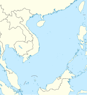
| [[Berkas: | |
| Lokasi | Laut Tiongkok Selatan |
| Koordinat | 10°22′37″N 114°21′57″E / 10.37694°N 114.36583°E |
| Kepulauan | Kepulauan Spratly |
| Wilayah | 51 hektare ([convert: unit tak dikenal])[1] |
| Panjang | 1.430 meter (1.560 yd) |
| Lebar | 402 meter (440 yd) |
| Wilayah administrasi | |
| {{country data Republik Tiongkok (Taiwan) |flag/core|name=Republik Tiongkok (Taiwan) |variant=|border=|size=}} | |
| Munisipalitas Distrik |
Kaohsiung Cijin |
| Diklaim oleh | |
| {{country data Republik Rakyat Tiongkok |flag/core|name=Republik Rakyat Tiongkok |variant=|border=|size=}} | |
| City | Sansha, Hainan |
| {{country data Filipina |flag/core|name=Filipina |variant=|border=|size=}} | |
| Munisipalitas | Kalayaan, Palawan |
| {{country data Vietnam |flag/core|name=Vietnam |variant=|border=|size=}} | |
| Distrik | Trường Sa, Khánh Hòa |
| Demografi | |
| Populasi | 220 personil militer, garda pesisir dan pendukung; 4 warga sipil[2] |
Pulau Taiping, juga dikenal sebagai Itu Aba, dan berbagai nama lainnya, adalah sebuah pulau terbesar di Kepulauan Spratly, Laut Tiongkok Selatan.[3][4][5][6] Pulau tersebut memiliki panjang 14 kilometer (8,7 mi) dan lebar 04 kilometer (2,5 mi), dengan luas 46 hektare ([convert: unit tak dikenal]).
Referensi
- ^ "外交部と農業委員会、「太平島陸地生態環境調査団」説明会を開催" (dalam bahasa Jepang). 2016-01-25. Diarsipkan dari versi asli tanggal 2016-03-08. Diakses tanggal 2016-02-02.
- ^ 護理師設籍南沙 創太平島首例
- ^ C. Michael Hogan (2011) South China Sea Topic ed. P.Saundry. Ed.-in-chief C.J.Cleveland. Encyclopedia of Earth. National Council for Science and the Environment. Washington DC
- ^ "Taiping Island". Spratly islands. Marine National Park Headquarters (Republic of China). Diakses tanggal 21 March 2014.
- ^ "Itu Aba – Inquirer Global Nation". Philippine Daily Inquirer. Diakses tanggal 19 Aug 2014.
- ^ Michael Gold. "Taiwan Considers Permanent Armed Ships For Disputed South China Sea Island". Reuters. Diarsipkan dari versi asli tanggal 2014-10-19. Diakses tanggal 16 Oct 2014.
Pranala luar
Wikimedia Commons memiliki media mengenai Taiping Island.
- The International Portal of Taiping Island (Taiping Island – The Beautiful and Sustainable Island)
- Satellite image of Taiping Island by Google Maps
- Putative States in the Spratly Archipelago
- "Ecological Resources". Discovering the South China Sea. vm.nthu.edu.tw. Diarsipkan dari versi asli tanggal 2005-11-24.
- "Itu Aba Island". Discovering the South China Sea. vm.nthu.edu.tw. Diarsipkan dari versi asli tanggal 2006-02-09.
- paper.wenweipo.com – (Perhaps) Contains an undoctored 2008 satellite photo of the island showing the runway and (one) adjacent "standing area".

