Kota Cotabato: Perbedaan antara revisi
Tampilan
Konten dihapus Konten ditambahkan
kTidak ada ringkasan suntingan |
|||
| Baris 50: | Baris 50: | ||
* Tamontaka VI |
* Tamontaka VI |
||
{{EndDiv}} |
{{EndDiv}} |
||
== Iklim == |
|||
<!--Start of weatherbox --> |
|||
{{-}} |
|||
<center>{{Weather box |
|||
|location = Cotabato City |
|||
|metric first = Yes |
|||
|single line = Yes |
|||
|Jan high C = 32 |
|||
|Feb high C = 32 |
|||
|Mar high C = 33 |
|||
|Apr high C = 33 |
|||
|May high C = 33 |
|||
|Jun high C = 32 |
|||
|Jul high C = 32 |
|||
|Aug high C = 31 |
|||
|Sep high C = 32 |
|||
|Oct high C = 32 |
|||
|Nov high C = 32 |
|||
|Dec high C = 32 |
|||
|year high C = 32 |
|||
|Jan low C = 21 |
|||
|Feb low C = 21 |
|||
|Mar low C = 21 |
|||
|Apr low C = 22 |
|||
|May low C = 22 |
|||
|Jun low C = 22 |
|||
|Jul low C = 22 |
|||
|Aug low C = 22 |
|||
|Sep low C = 22 |
|||
|Oct low C = 22 |
|||
|Nov low C = 22 |
|||
|Dec low C = 21 |
|||
|year low C = 22 |
|||
|Jan precipitation mm = 60 |
|||
|Feb precipitation mm = 80 |
|||
|Mar precipitation mm = 90 |
|||
|Apr precipitation mm = 120 |
|||
|May precipitation mm = 230 |
|||
|Jun precipitation mm = 220 |
|||
|Jul precipitation mm = 220 |
|||
|Aug precipitation mm = 320 |
|||
|Sep precipitation mm = 240 |
|||
|Oct precipitation mm = 250 |
|||
|Nov precipitation mm = 170 |
|||
|Dec precipitation mm = 90 |
|||
|year precipitation mm = 2160 |
|||
|source 1 = Weatherbase.com<ref>{{cite web|url=http://www.weatherbase.com/weather/weather.php3?s=64789&refer=&units=metric&cityname=Cotabato-Soccsksargen-Philippines|title=Historical Weather for Cotabato, Soccsargen, Philippines|accessdate=2011-08-15}}</ref> |
|||
|date=April 2011 |
|||
}} |
|||
</center> |
|||
== Galeri == |
== Galeri == |
||
Revisi per 8 Januari 2012 06.25

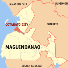
Cotabato City adalah kota yang terletak di provinsi Maguindanao, Filipina.
Pada tahun 2010, kota ini memiliki populasi sebesar 259.153 jiwa.
Pembagian wilayah
Secara administratif Cotabato City terbagi menjadi 37 barangay, yaitu:
- Bagua
- Bagua II
- Kalanganan
- Poblacion
- Rosary Heights
- Bagua I
- Bagua II
- Bagua III
- Kalanganan I
- Kalanganan II
- Poblacion I
- Poblacion II
- Poblacion III
- Poblacion IV
- Poblacion V
- Poblacion VI
- Poblacion VII
- Poblacion VIII
- Poblacion IX
- Rosary Heights I
- Rosary Heights II
- Rosary Heights III
- Rosary Heights IV
- Rosary Heights V
- Rosary Heights VI
- Rosary Heights VII
- Rosary Heights VIII
- Rosary Heights IX
- Rosary Heights X
- Rosary Heights XI
- Rosary Heights XII
- Rosary Heights XIII
- Tamontaka I
- Tamontaka II
- Tamontaka III
- Tamontaka IV
- Tamontaka V
- Tamontaka VI
Iklim
| Data iklim Cotabato City | |||||||||||||
|---|---|---|---|---|---|---|---|---|---|---|---|---|---|
| Bulan | Jan | Feb | Mar | Apr | Mei | Jun | Jul | Agt | Sep | Okt | Nov | Des | Tahun |
| Rata-rata tertinggi °C (°F) | 32 (90) |
32 (90) |
33 (91) |
33 (91) |
33 (91) |
32 (90) |
32 (90) |
31 (88) |
32 (90) |
32 (90) |
32 (90) |
32 (90) |
32 (90) |
| Rata-rata terendah °C (°F) | 21 (70) |
21 (70) |
21 (70) |
22 (72) |
22 (72) |
22 (72) |
22 (72) |
22 (72) |
22 (72) |
22 (72) |
22 (72) |
21 (70) |
22 (72) |
| Presipitasi mm (inci) | 60 (2.36) |
80 (3.15) |
90 (3.54) |
120 (4.72) |
230 (9.06) |
220 (8.66) |
220 (8.66) |
320 (12.6) |
240 (9.45) |
250 (9.84) |
170 (6.69) |
90 (3.54) |
2.160 (85,04) |
| Sumber: Weatherbase.com[1] | |||||||||||||
Galeri
-
Rio Grande de Mindanao, Cotabato City
Pranala luar
- Sangguniang Panlungsod of Cotabato City Website
- All About Cotabato City
- Cotabato City
- The Mindanao Examiner Newspaper
- NSCB details for cotabato city geographic code
- Philippine Standard Geographic Code
- 1995 Philippine Census Information
- 2000 Philippine Census Information
- 2007 Philippine Census Information
7°13′N 124°15′E / 7.217°N 124.250°E
- ^ "Historical Weather for Cotabato, Soccsargen, Philippines". Diakses tanggal 2011-08-15.

