
Berkas:Tondo and Pasig 1450.png

Ukuran asli (1.778 × 1.699 piksel, ukuran berkas: 90 KB, tipe MIME: image/png)
Ringkasan
| Deskripsi |
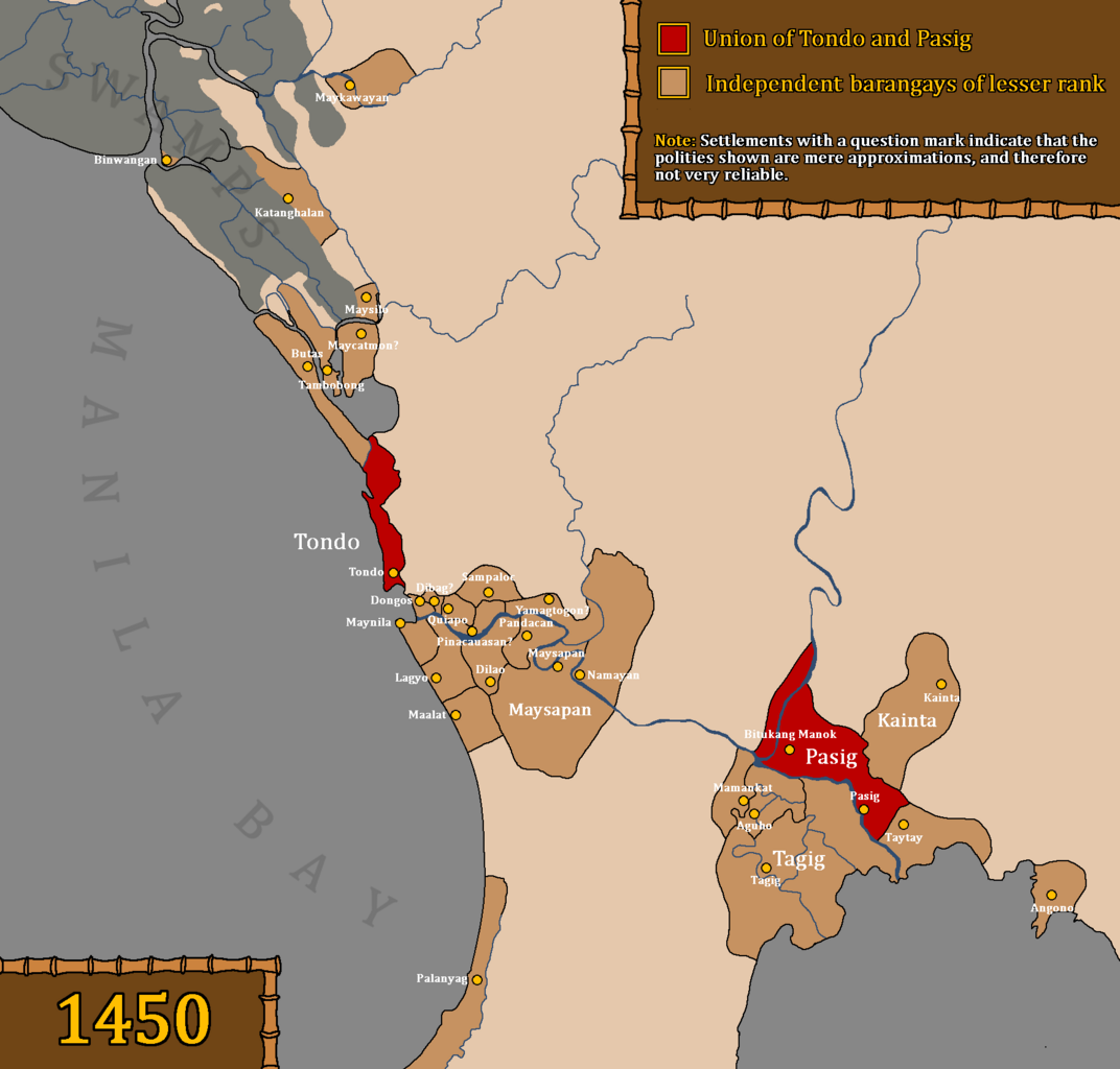
Map of the Union of Tondo and Pasig, also referred to as the Kingdom of Tondo, as well as other influenced barangays during the rule of Dayang Kalangitan in circa 1450. This map uses question marks for places whose locations are deemed uncertain and not fully reliable. Interpretations based on "Estado, Topográfico, Estadistíco, Histórico—Religioso, de la Santa y Apostólica Provincia de San Gregorio Magno, de Religiosos Menores Descalzos de la Regular y Mas Estrecha Observancia De Nuestro Padre San Francisco, en las Islas Filipinas" by Fr. Felix Huerta Places like Meycatmon, Dibag, Pinacauasan, and Yamagtogon have uncertain locations, but are placed with approximate locations because Fr. Felix Huerta seems to have arranged the settlements in the right order, from Meycatmon "hasta" (until) Meysapan (Santa Ana). So, from Meycatmon all the way to Meysapan. Meycatmon (potentially the barangay of Catmon north of Tondo), Calatondongan (Tondo/Tondong/Tundun), Dongos (Santo Cristo de Longos, modern-day Binondo and San Nicolas), Dibag, Pinacauasan, Yamagtogon until Meysapan. Santa Cruz, San Miguel, and Santa Mesa do not have precolonial names preserved, despite having proof that it was inhabited prior to Spanish colonization. Therefore, in the area from Santa Cruz to Santa Mesa are the likely locations of Dibag, Pinacauasan and Yamagtogon, in a left-to-right order. Another thing that the author wants to clarify is that Namayan was a confederation and not a single entity, and as stated in Fr. Felix Huerta's work, ruled by a "petty king" named Lakan Tagkan. While the confederation was most likely headed by Namayan by 1570, this did not mean that they had direct control over other barangays. Also, there is no proof that Namayan held some degree of control over the mentioned territories in Fr. Felix Huerta's document before Lakan Tagkan. Furthermore, the excavations of old Chinese goods and piloncitos found in Santa Ana as stated in the Namayan Wikipedia page are not an indicator of Namayan's territories and influence. It was simply a proof of economic relations with the states around them. Furthermore, if we make logical estimates as to when Lakan Tagkan may have possibly ruled, based on genealogical records and the potential lifespan of people at the time, Lakan Tagkan may have only ruled in the mid to late 1400s. Lakan Tagkan is the great grandfather of Calamayin, who ruled during the 1570s. Fr. Felix Huerta also mentions that the "origins of the naturales of these territories" came from the kingdom established by Lakan Tagkan, so it is certain that Namayan only started dominating under Lakan Tagkan. Pasay was not included as it was a newly established settlement only during the reign of Lakan Tagkan, and this map precedes the reign of Lakan Tagkan of Namayan. There is also no proof that Namayan and Meysapan are the same entity. Fr. Felix Huerta has made it clear that Namayan was merely absorbed into Santa Ana de Sapa into a barrio (village) during the Spanish era. He did not mention that Meysapan was the seat of power, but Namayan. He further stated that Meysapan was only a territory of Namayan, never mentioning that Meysapan was ever Namayan. This was an indication that Meysapan (Sapa) and Namayan were two different settlements. Therefore, Namayan (in Mandaluyong) was the capital of Namayan, not Santa Ana de Sapa. Santa Ana was only made the seat of power of large swathes of areas during the Spanish era. It is very possible but not certain that Fr. Felix Huerta misinterpreted the barangays within the confederation headed by Namayan as Namayan's "territories", as no older Spanish accounts prior to Felix Huerta's work in the 19th century seem to mention various places all as part of one centralized kingdom known as Namayan. Furthermore, places like Pandacan, Taguig, Catanghalan, Maysilo/Misil, Polo, Tambobong, Navotas, and other areas clearly had their own local datus, hence they were able to take part in the Tondo Conspiracy of 1587. Binwangan (Binwangan, Obando) was also mentioned in the Laguna Copperplate Inscription. It is also not unlikely for Tondo to be absorbed into the confederation headed by Namayan under Lakan Tagkan. As stated by Nick Joaquin, that Tondo had "replaced Namayan as the chief port of entry on Manila Bay", indicating that Tondo may have only recently became increasingly less dependent and eventually became independent from Namayan. Fr. Felix Huerta made mention of Pandacan as part of Namayan, but as stated before, and according to older Spanish sources, this place had its own local datu. The Spaniards as well as Chinese records have a history of simplifying this confederation system in Luzon, insofar as simplifying them as the "Kingdom of Tondo" (Spanish records) or the "Kingdom of Lusung" (History of Ming). It is the best option to take account of these clear biases when portraying or discussing the system of governance in the pre-colonial Tagalog region. |
| Tanggal | |
| Sumber |
Original work by DeliriumMaps (Delirium333). The information was gathered from the following sources: Wikipedia Sources
Other Sources
|
| Pembuat | Delirium333 |
Lisensi

|
Diizinkan untuk menyalin, mendistribusikan dan/atau memodifikasi dokumen ini di bawah syarat-syarat Lisensi Dokumentasi Bebas GNU, Versi 1.2 atau lebih baru yang diterbitkan oleh Free Software Foundation; tanpa Bagian Invarian, tanpa Teks Sampul Depan, dan tanpa Teks Sampul Belakang. Salinan lisensi dimasukkan ke bagian yang berjudul Lisensi Dokumentasi Bebas GNU. |
- Anda diizinkan:
- untuk berbagi – untuk menyalin, mendistribusikan dan memindahkan karya ini
- untuk menggubah – untuk mengadaptasi karya ini
- Berdasarkan ketentuan berikut:
- atribusi – Anda harus mencantumkan atribusi yang sesuai, memberikan pranala ke lisensi, dan memberi tahu bila ada perubahan. Anda dapat melakukannya melalui cara yang Anda inginkan, namun tidak menyatakan bahwa pemberi lisensi mendukung Anda atau penggunaan Anda.
- berbagi serupa – Apabila Anda menggubah, mengubah, atau membuat turunan dari materi ini, Anda harus menyebarluaskan kontribusi Anda di bawah lisensi yang sama seperti lisensi pada materi asli.
Riwayat berkas
Klik pada tanggal/waktu untuk melihat berkas ini pada saat tersebut.
| Tanggal/Waktu | Miniatur | Dimensi | Pengguna | Komentar | |
|---|---|---|---|---|---|
| 7 September 2023 08.47 |  | 1.778 × 1.699 (115 KB) | Delirium333 | katanghalan | |
| 6 September 2023 14.49 |  | 1.778 × 1.699 (116 KB) | Delirium333 | pasay was autonomous and whether palanyag (paranaque) was under namayan is a vague statement. sorry. | |
| 5 September 2023 16.16 |  | 1.778 × 1.699 (137 KB) | Delirium333 | had to simplify namayan to be more inclusive as settlements like yamagtogon, pinacauasan, dongos, etc etc were not shown because their locations are currently not possible to track by simply using internet sources. i also removed the settlements of ermita and malate as there was no proof they were precolonial. my mistake. | |
| 25 Februari 2023 15.25 |  | 1.778 × 1.699 (143 KB) | Delirium333 | accuracy enhanced | |
| 15 Februari 2023 04.38 |  | 1.778 × 1.699 (67 KB) | Delirium333 | obtained info from https://en.wiki-indonesia.club/wiki/Pasay. so changes were made | |
| 15 Februari 2023 04.21 |  | 1.778 × 1.699 (67 KB) | Delirium333 | fixed | |
| 12 Februari 2023 10.53 |  | 1.778 × 1.699 (67 KB) | Delirium333 | fixed | |
| 9 Februari 2023 23.59 |  | 1.778 × 1.699 (62 KB) | Delirium333 | added binwangan | |
| 9 Februari 2023 23.52 |  | 1.778 × 1.699 (62 KB) | Delirium333 | fixing inaccuracies | |
| 15 Juli 2022 08.39 |  | 2.100 × 1.165 (148 KB) | Delirium333 | {{Information |Description=Map of Tondo and Namayan in 1450. |Source=Wikipedia |Date=Jly 15, 2022 |Author=Delirium333 |Permission= |other_versions= }} |
Penggunaan berkas
Tidak ada halaman yang menggunakan berkas ini.
Penggunaan berkas global
Wiki lain berikut menggunakan berkas ini:
- Penggunaan pada en.wiki-indonesia.club
- Penggunaan pada es.wiki-indonesia.club
- Penggunaan pada it.wiki-indonesia.club
- Penggunaan pada ko.wiki-indonesia.club
- Penggunaan pada pt.wiki-indonesia.club
- Penggunaan pada ru.wiki-indonesia.club
- Penggunaan pada sr.wiki-indonesia.club
- Penggunaan pada tl.wiki-indonesia.club
- Penggunaan pada zh.wiki-indonesia.club