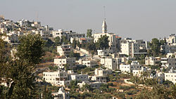
Taybeh
Tampilan
Taybeh
الطيبه | |
|---|---|
Desa | |
 | |
| Grid position | 178/151 PAL |
| Kegubernuran | Ramallah dan al-Bireh |
| Ketinggian | 850 m (2,790 ft) |
| Populasi (2007) | |
| • Total | 1.452 |
| Situs web | www.taybehmunicipality.org |
Taybeh (bahasa Arab: الطيبة) adalah sebuah desa Palestina di Tepi Barat, 15 kilometer dari timur laut Yerusalem[1] dan 12 kilometer dari timur laut Ramallah di Kegubernuran Ramallah dan al-Bireh, 850 meter diatas permukaan laut. Menurut Biro Statistik Pusat Palestina, Taybeh memiliki penduduk sejumlah 1,452 orang pada 2007.[2] Desa tersebut merupakan komunitas yang semua anggotanya Kristen terakhir di Tepi Barat.[3]
Referensi
- ^ In search of the West Bank’s elusive Sufi Trail, Jerusalem Post
- ^ 2007 PCBS Census. Biro Statistik Pusat Palestina. p.114.
- ^ "A Palestinian Brewery Grows in the West Bank". Time (majalah). 8 Oktober 2009. Diarsipkan dari versi asli tanggal 2013-08-26. Diakses tanggal 2015-12-16.
Daftar pustaka
Wikimedia Commons memiliki media mengenai Taybeh.
- Barron, J. B., ed. (1923). Palestine: Report and General Abstracts of the Census of 1922 (PDF). Government of Palestine.
- Clermont-Ganneau, Charles Simon (1896). [ARP] Archaeological Researches in Palestine 1873-1874, translated from the French by J. McFarlane. 2. London: Palestine Exploration Fund. (p.280, p.293, p.295-p.298 )
- Conder, Claude Reignier; Kitchener, Herbert H. (1882). The Survey of Western Palestine: Memoirs of the Topography, Orography, Hydrography, and Archaeology. 2. London: Committee of the Palestine Exploration Fund.
- Dauphin, Claudine (1998). La Palestine byzantine, Peuplement et Populations. BAR International Series 726 (dalam bahasa French). III : Catalogue. Oxford: Archeopress.
- Ellenblum, Ronnie (2003). Frankish Rural Settlement in the Latin Kingdom of Jerusalem. Cambridge University Press. ISBN 9780521521871. (pp. 120- 121)
- Ernoul, Bernard le Trésorier; Mas Latrie, Louis (1871). Chronique d'Ernoul et de Bernard le Trésorier / publiée, pour la première ... (dalam bahasa French). Mme Ve J. Renouard.
- Finkelstein, Israel; Lederman, Zvi, ed. (1997). Highlands of many cultures. Tel Aviv: Institute of Archaeology of Tel Aviv University Publications Section. ISBN 965-440-007-3. (II p. 587)
- Guérin, Victor (1869). Description Géographique Historique et Archéologique de la Palestine (dalam bahasa French). 1: Judee, pt. 3. Paris: L'Imprimerie Nationale.
- Guérin, Victor (1874). Description Géographique Historique et Archéologique de la Palestine (dalam bahasa French). 2: Samarie, pt. 1. Paris: L'Imprimerie Nationale.
- Hadawi, Sami (1970). Village Statistics of 1945: A Classification of Land and Area ownership in Palestine. Palestine Liberation Organization Research Center.
- Hütteroth, Wolf-Dieter; Abdulfattah, Kamal (1977). Historical Geography of Palestine, Transjordan and Southern Syria in the Late 16th Century. Erlanger Geographische Arbeiten, Sonderband 5. Erlangen, Germany: Vorstand der Fränkischen Geographischen Gesellschaft. ISBN 3-920405-41-2.
- Mills, E., ed. (1932). Census of Palestine 1931. Population of Villages, Towns and Administrative Areas (PDF). Jerusalem: Government of Palestine.
- McCown, C. (1923) Muslim Shrines in Palestine. AASOR (=Annual of the American Schools of Oriental Research), 2-3, pp 47–79 p.66, Pl.22
- Palmer, E. H. (1881). The Survey of Western Palestine: Arabic and English Name Lists Collected During the Survey by Lieutenants Conder and Kitchener, R. E. Transliterated and Explained by E.H. Palmer. Committee of the Palestine Exploration Fund.
- Robinson, Edward; Smith, Eli (1841). Biblical Researches in Palestine, Mount Sinai and Arabia Petraea: A Journal of Travels in the year 1838. 2. Boston: Crocker & Brewster.
- Pringle, Denys (1997). Secular buildings in the Crusader Kingdom of Jerusalem: an archaeological Gazetter. Cambridge University Press. ISBN 0521 46010 7.
- Pringle, Denys (1998). The Churches of the Crusader Kingdom of Jerusalem: L-Z (exluding Tyre). 2. Cambridge University Press. ISBN 0 521 39037 0.
- RHC Occ: Recueil des historiens des croisades. Historiens Occidentaux (dalam bahasa French). 2. Paris: Imprimerie nationale. 1859.
- Röhricht, Reinhold (1893). (RRH) Regesta regni Hierosolymitani (MXCVII-MCCXCI) (dalam bahasa Latin). Berlin: Libraria Academica Wageriana.
- Strehlke, Ernst, ed. (1869). Tabulae Ordinis Theutonici ex tabularii regii Berolinensis codice potissimum. Berlin: Weidmanns.
- Strange, le, Guy (1890). Palestine Under the Moslems: A Description of Syria and the Holy Land from A.D. 650 to 1500. Committee of the Palestine Exploration Fund.
Pranala luar
- Welcome To al-Tayyiba
- Survey of Western Palestine, Map 14: IAA, Wikimedia commons
- Et Taiyiba Town (Including Badiw al Mu’arrajat Locality) (Fact Sheet), AJJ
- Et Taiyiba Town Profile (including Badiw al Mu’arrajat Locality), AJJ
- Areal photo, AJJ

