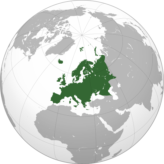
Berkas:Europe orthographic Caucasus Urals boundary.svg
Tampilan

Ukuran pratayang PNG ini dari berkas SVG ini: 537 × 536 piksel Resolusi lainnya: 240 × 240 piksel | 481 × 480 piksel | 769 × 768 piksel | 1.026 × 1.024 piksel | 2.052 × 2.048 piksel.
Ukuran asli (Berkas SVG, secara nominal 537 × 536 piksel, besar berkas: 77 KB)
Riwayat berkas
Klik pada tanggal/waktu untuk melihat berkas ini pada saat tersebut.
| Tanggal/Waktu | Miniatur | Dimensi | Pengguna | Komentar | |
|---|---|---|---|---|---|
| 18 Oktober 2014 12.19 |  | 537 × 536 (197 KB) | Deni Mataev | Reverted to version as of 13:35, 3 June 2014 Georgia as of whole is not part of Europe geographically | |
| 18 Oktober 2014 10.57 |  | 537 × 536 (238 KB) | Politologia | Updated Accuracy of borders | |
| 3 Juni 2014 13.35 |  | 537 × 536 (197 KB) | Rob984 | Removed margin and added gradient. | |
| 19 Januari 2014 19.55 | Miniatur tidak tersedia | 541 × 541 (199 KB) | Chipmunkdavis | Reverted to version as of 06:45, 11 April 2011 Very strange to have non-oceanic water shown only in the green bit of the map | |
| 18 Januari 2014 19.01 |  | 541 × 541 (184 KB) | Fulvio314 | Cyprus light green. See [https://en.wiki-indonesia.club/wiki/Cyprus#cite_note-13]. | |
| 11 April 2011 06.45 |  | 541 × 541 (199 KB) | Dbachmann | {{Information |Description={{en|1=Mao of Europe. The continental boundary to Asia as indicated is the standard convention following the Caucasus crest, the Urals River and the Urals Mountains to the Sea of Kara}} {{ar|1=الخريطة الهجائية ل� |
Penggunaan berkas
Halaman berikut menggunakan berkas ini:
Penggunaan berkas global
Wiki lain berikut menggunakan berkas ini:
- Penggunaan pada ab.wiki-indonesia.club
- Penggunaan pada ace.wiki-indonesia.club
- Penggunaan pada ady.wiki-indonesia.club
- Penggunaan pada af.wiki-indonesia.club
- Penggunaan pada ar.wiki-indonesia.club
- بوابة:آسيا
- بوابة:أوروبا
- بوابة:إفريقيا
- بوابة:القارة القطبية الجنوبية
- بوابة:القارة القطبية الجنوبية/بوابات شقيقة
- قائمة جوازات السفر
- بوابة:تركيا
- بوابة:تركيا/بوابات شقيقة
- بوابة:جغرافيا/مقالة مختارة/أرشيف
- المرأة في تركيا
- بوابة:أوروبا/واجهة
- بوابة:تصفح
- بوابة:تصفح/جغرافيا
- قائمة مفاتيح الاتصال الدولية
- المرأة في ألمانيا
- بوابة:إسطنبول
- بوابة:آسيا/بوابات شقيقة
- ويكيبيديا:مقالة الصفحة الرئيسية المختارة/398
- بوابة:جغرافيا/مقالة مختارة/21
- معاملة المثليين في أوروبا
- المرأة في أوروبا
- المرأة في البرتغال
- المرأة في فنلندا
- المرأة في مقدونيا الشمالية
- المرأة في ترانسنيستريا
- المرأة في الفاتيكان
- المرأة في أذربيجان
- المرأة في اليونان
- المرأة في ألبانيا
- المرأة في إيطاليا
- المرأة في الجبل الأسود
Lihat lebih banyak penggunaan global dari berkas ini.


