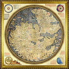
Peta Fra Mauro
Tampilan


Peta Fra Mauro, "considered the greatest memorial of medieval cartography",[2] is a map of the world made around 1450 by the Italian cartographer Fra Mauro. It is a circular planisphere drawn on parchment and set in a wooden frame that measures over two by two meters. It includes Asia, the Indian Ocean, Africa, Europe and the Atlantic. It is oriented with south at the top.
Catatan
- ^ NASA Landsat Science 2014
- ^ Almagià 1944, hlm. 32-40, discussing the copy of another map by Fra Mauro, in the Vatican Library.
Referensi
- Almagià, Roberto (1944), Monumenta cartographica vaticana, Città del Vaticano
- British Library (2010), Magnificent Maps: Fra Mauro World map
- Brotton, Jerry (2014), Great Maps: the worlds masterpieces explored and explained, Dk Smithsonian, ISBN 978-1465424631
- Falchetta, Piero (2006), Fra Mauro's World Map, Brepols, ISBN 2-503-51726-9
- John, Murray (1875), The Book of Ser Marco Polo, the Venetian: Concerning the Kingdoms and Marvels of the East
- NASA Landsat Science (2014-01-17), Geographia: From Antiquity to the Space Age - Fra Mauro’s Mappamundi
- Needham, Joseph (1971), Science and Civilisation in China
- Siebold, J (2015), Cartographic Images: Fra Mauro’s Mappamundi
- Suarez, Thomas (1999), Early mapping of Southeast Asia
- Woodward, David (1996), Art and Cartography, Chicago: University of Chicago Press, ISBN 978-0-226-90722-2
- Zurla, Placido (1806), Il mappamondo di fra Mauro, Venice
Pranala luar
- Magnificent Maps: Fra Mauro World map Lets you explore the 1804 copy in the British Library. Deep zoom feature, highlighted details. Video introduction from Curator of Antiquarian Mapping.
- Cartographic-Images.net: Fra Mauro’s Mappamundi Monograph on Fra Mauro's map.
- Transcription of the text on the map (.pdf) In Italian. By Piero Falchetta.
- Biblioteca Nazionale Marciana di Venezia In Italian. Informations about the map today.
