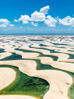
Taman Nasional Lençóis Maranhenses
Tampilan
| Taman Nasional Lençóis Maranhenses | |
|---|---|
IUCN Kategori II (Taman Nasional) | |
 Taman Nasional Lençóis Maranhenses | |
| Letak | Maranhão Timur Laut, Brasil |
| Koordinat | 02°32′S 43°07′W / 2.533°S 43.117°W |
| Luas | 155.000 hektare (380.000 ekar).[1] |
| Penetapan | Taman nasional |
| Dibentuk | 2 Juni 1981[2] |
| Pihak pengelola | IBAMA |
Taman Nasional Lençóis Maranhenses (Parque Nacional dos Lençóis Maranhenses[a]) adalah sebuah taman nasional yang terletak di negara bagian Maranhão di Brazil timur laut, tepat di timur Baía de São José. Dilindungi pada 2 Juni 1981, taman seluas 155.000 ha (380.000-ekar) ini meliputi 70 km (43 mi) garis pantai, dan interior yang terdiri dari bukit pasir bergulir. During the rainy season, the valleys among the dunes fill with freshwater lagoons, prevented from draining due to the impermeable rock beneath. The park is home to a range of species, including four listed as endangered, and has become a popular destination for ecotourists.
Catatan
Referensi
- ^ Kesalahan pengutipan: Tag
<ref>tidak sah; tidak ditemukan teks untuk ref bernamahuffpo - ^ "Parque Nacional dos Lençóis Maranhenses – Lençóis Maranhenses National Park". UNESCO. Diakses tanggal 6 August 2018.
- ^ Ribeiro, Ronaldo (2010). "A Sea of Dunes". National Geographic. Diakses tanggal 24 August 2018.
Pranala luar
Wikimedia Commons memiliki media mengenai Lençóis Maranhenses.
Wikivoyage memiliki panduan wisata Lençóis Maranhenses.
