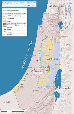
Teritori Palestina
Teritorial Palestina الأراضي الفلسطينية al-Arāḍī al-Filasṭīniyya | |
|---|---|
 | |
 | |
| Kota | |
| Bahasa | |
| Kelompok etnik | |
| Demonim | |
| Luas | |
- Total | 6,220 km2 |
| 3.5 | |
| 5,860 km2[1] (Laut Mati: 220 km2) | |
| 360 km2[2] | |
| Populasi | |
- Palestina (2014) | 4,550,000[3] |
- Pemukim (2012) | 564,000[5] |
- Sensus Penduduk 2007 | 3,719,189 (Pal.)[3][4] |
| 654[4]/km2 | |
| IPM (2010) | 0,645[6] sedang · 97th |
| Mata uang |
|
| Zona waktu | WET (UTC+2) |
- Musim panas (DST) | UTC+3 (WMPET) |
| Lajur kemudi | right |
| Kode telepon | +970d |
| Ranah Internet | |
| |
"Teritorial Palestina" dan "teritorial Palestina yang diduduki" adalah deskripsi yang sering digunakan untuk mendeskripsikan Tepi Barat (termasuk Yerusalem Timur) dan Jalur Gaza, yang diduduki atau tempat lainnya yang berada di bawah kontrol Israel.[7][8][9] Pemerintah Israel menyatakan bahwa wilayah tersebut merupakan wilayah sengketa.[10][11] Teritorial tersebut, melalui subyek untuk negosiasi masa depan, didefinisikan oleh Garis Hijau.
Istilah "Teritorial Palestina yang Diduduki" digunakan oleh Perserikatan Bangsa-Bangsa (PBB) dan organisasi internasional lainnya antara 1998 sampai 2013 dalam rangka merujuk kepada Otoritas Nasional Palestina. Dimulai pada 2012, Sekretariat PBB menggantinya dengan istilah Negara Palestina.[12] ISO mengadopsi perubahan nama tersebut pada 2013.[13] Namun, pada Agustus 2015, Dewan Keamanan PBB masih menganggap Palestina sebagai negara non-berdaulat,<ref name=IBN-UNSC>{{cite news|last1=McHigh|first1=Jess|title=Israel-Palestine Conflict: French UN Security Council Resolution Off The Table In Favor Of Palestinian Stari
Referensi
- ^ "CIA - The World Factbook". cia.gov. Diakses tanggal 28 November 2012.
- ^ "CIA - The World Factbook". cia.gov. Diakses tanggal 28 November 2012.
- ^ a b http://www.pcbs.gov.ps/Portals/_Rainbow/Documents/gover_e.htm
- ^ a b http://www.pcbs.gov.ps/Portals/_pcbs/PressRelease/population_dE.pdf
- ^ Kesalahan pengutipan: Tag
<ref>tidak sah; tidak ditemukan teks untuk ref bernamaPCBS_settlements_2012 - ^ "| Human Development Reports" (PDF). Hdr.undp.org. Diakses tanggal 2016-06-10.
- ^ "Palestinian Territories". State.gov. 22 April 2008. Diakses tanggal 26 December 2012.
- ^ Le More, Anne (2008). International assistance to the Palestinians after Oslo: political guilt, wasted money. Routledge studies on the Arab-Israeli conflict. 1. London and New York: Routledge. hlm. 27. ISBN 978-0-415-45385-1.
- ^ "December Overview" (PDF). UNOCHA. December 2009. Diakses tanggal 3 January 2010.
- ^ FAQ: The Peace process with the Palestinians – Dec 2009. Mfa.gov.il. Retrieved on 2012-01-15.
- ^ From "Occupied Territories" to "Disputed Territories," by Dore Gold. Jcpa.org. Retrieved on 2012-01-15.
- ^ Gharib, Ali (2012-12-20). "U.N. Adds New Name: "State of Palestine"". The Daily Beast. Diakses tanggal 2013-01-10.
- ^ "Name Change: State of Palestine"
Catatan
- ^ Israeli documentation provides population figures for the whole of Jerusalem without specific information on East Jerusalem being provided.
Pranala luar
| Cari tahu mengenai Palestinian territories pada proyek-proyek Wikimedia lainnya: | |
| Definisi dan terjemahan dari Wiktionary | |
| Gambar dan media dari Commons | |
| Berita dari Wikinews | |
| Kutipan dari Wikiquote | |
| Teks sumber dari Wikisource | |
| Buku dari Wikibuku | |
- Statistical Atlas of Palestine at the Palestinian Central Bureau of Statistics.
- Global Integrity Report: West Bank has a governance and anti-corruption profile.
- Gaza Strip di CIA World Factbook.
- West Bank di CIA World Factbook.
- Palestinian Territories at the United States Department of State.
- Palestine from UCB Libraries GovPubs.
- Palestinian Territory di Curlie (dari DMOZ)
- Palestine under the Ottoman Rule
- Palestinian territories street-art
- The Question of Palestine & the United NationsPDF, published by the United Nations Department of Public Information, March 2003. UN Brochure DPI/2276. Online, chapters are in PDF format.
Templat:Topik Palestina 31°53′N 35°12′E / 31.883°N 35.200°E


