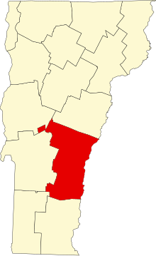
County Windsor, Vermont


County Windsor adalah sebuah county yang terletak di negara bagian Vermont, Amerika Serikat. Pada sensus 2020, jumlah penduduknya adalah 57.753 jiwa.[1] Ibu kotanya ialah kota Woodstock,[2] serta kota terbesar di county ini adalah kota Hartford.
Sejarah
County Windsor adalah salah satu dari beberapa county Vermont yang dibentuk dari tanah yang diserahkan oleh negara bagian New York pada tanggal 15 Januari 1777, ketika Vermont mendeklarasikan dirinya sebagai negara bagian yang berbeda dari New York.[3][4][5] Tanah tersebut awalnya diperebutkan oleh Massachusetts, New Hampshire, New France dan Belanda Baru, namun tetap tidak jelas sampai tanggal 20 Juli 1764, ketika Raja George III menetapkan batas antara New Hampshire dan New York di sepanjang tepi barat Sungai Connecticut, utara Massachusetts dan selatan paralel 45 derajat lintang utara. New York menyerahkan tanah yang diperoleh ke County Albany.[6][7] Pada tanggal 12 Maret 1772, County Albany dipecah menjadi County Charlotte,[8] dan situasi ini berlanjut hingga kemerdekaan Vermont dari New York dan Inggris, yang, bagaimanapun, tidak mengakhiri persaingan tersebut.
County Windsor didirikan pada 16 Februari 1781, dari beberapa bagian County Cumberland dan diorganisasi pada tahun yang sama.[9]
Geografi
Menurut Biro Sensus A.S., wilayah ini memiliki luas total 977 mil persegi (2.530 km2), dimana 969 mil persegi (2.510 km2) merupakan daratan dan 7,4 mil persegi (19 km2) (0,8%) adalah perairan.[10] Ini adalah county terbesar berdasarkan wilayah di Vermont.
Demografi
| Populasi historis | |||
|---|---|---|---|
| Sensus | Pop. | %± | |
| 1790 | 15.740 | — | |
| 1800 | 26.944 | 71,2% | |
| 1810 | 34.877 | 29,4% | |
| 1820 | 38.233 | 9,6% | |
| 1830 | 40.625 | 6,3% | |
| 1840 | 40.356 | −0,7% | |
| 1850 | 38.504 | −4,6% | |
| 1860 | 37.193 | −3,4% | |
| 1870 | 36.063 | −3,0% | |
| 1880 | 35.196 | −2,4% | |
| 1890 | 31.706 | −9,9% | |
| 1900 | 32.225 | 1,6% | |
| 1910 | 33.681 | 4,5% | |
| 1920 | 36.984 | 9,8% | |
| 1930 | 37.416 | 1,2% | |
| 1940 | 37.862 | 1,2% | |
| 1950 | 40.885 | 8,0% | |
| 1960 | 42.483 | 3,9% | |
| 1970 | 44.082 | 3,8% | |
| 1980 | 51.030 | 15,8% | |
| 1990 | 54.055 | 5,9% | |
| 2000 | 57.418 | 6,2% | |
| 2010 | 56.670 | −1,3% | |
| Sensus Sepuluh Tahunan AS[11] 1790–1960[12] 1900–1990[13] 1990–2000[14] 2010–2018[1] | |||
Pada Sensus Amerika Serikat 2010, terdapat 56.670 orang, 24.753 rumah tangga, dan 15.420 keluarga yang tinggal di wilayah tersebut.[15] Kepadatan penduduknya adalah 58,5 jiwa per mil persegi (22,6/km2). Terdapat 34.118 unit rumah dengan kepadatan rata-rata 35,2 unit per mil persegi (13,6 unit/km2).[16] Komposisi ras di wilayah tersebut adalah 96,3% berkulit putih, 0,9% Asia, 0,6% kulit hitam atau Afrika Amerika, 0,3% Indian Amerika, 0,2% dari ras lain, dan 1,7% dari dua ras atau lebih. Mereka yang berasal dari Hispanik atau Latin berjumlah 1,2% dari populasi.[15]
Referensi
- ^ a b "State & County QuickFacts". United States Census Bureau. Diakses tanggal October 28, 2021.
- ^ "Find a County". National Association of Counties. Diakses tanggal June 7, 2011.
- ^ Slade, William, Jr., comp. Vermont State Papers: Being a collection of Records and Documents Connected with the Assumption and Establishment of Government by the People of Vermont, Together with the Journal of the Council of Safety, the First Constitution, the Early Journals of the General Assembly, and the Laws from the Year 1779 to 1786, Inclusive. Middlebury, 1823. pp. 70–73.
- ^ Van Zandt, Franklin K. Boundaries of the United States and the Several States. Geological Survey Professional Paper 909. Washington, DC; Government Printing Office, 1976. The Standard Compilation for its subject. P. 64.
- ^ Williamson, Chilton. Vermont in Quandary: 1763–1825. Growth of Vermont series, Number 4.Montperler: Vermont Historical Series, 1949. PP. 82–84; map facing 95, 100–102, 112–113.
- ^ Slade, William, Jr., comp. Vermont State Papers: Being a collection of Records and Documents Connected with the Assumption and Establishment of Government by the People of Vermont, Together with the Journal of the Council of Safety, the First Constitution, the Early Journals of the General Assembly, and the Laws from the Year 1779 to 1786, Inclusive. Middlebury, 1823. pp. 13–19.
- ^ Van Zandt, Franklin K. Boundaries of the United States and the Several States. Geological Survey Professional Paper 909. Washington, DC; Government Printing Office, 1976. The Standard Compilation for its subject. P. 63.
- ^ New York Colonial Laws, Chapter 1534; Section 5; Paragraph 321)
- ^ "Vermont: Individual County Chronologies". Vermont Atlas of Historical County Boundaries. The Newberry Library. 2008. Diakses tanggal June 30, 2015.
- ^ "2010 Census Gazetteer Files". United States Census Bureau. August 22, 2012. Diakses tanggal June 29, 2015.
- ^ "U.S. Decennial Census". United States Census Bureau. Diakses tanggal June 29, 2015.
- ^ "Historical Census Browser". University of Virginia Library. Diakses tanggal June 29, 2015.
- ^ Forstall, Richard L., ed. (March 27, 1995). "Population of Counties by Decennial Census: 1900 to 1990". United States Census Bureau. Diakses tanggal June 29, 2015.
- ^ "Census 2000 PHC-T-4. Ranking Tables for Counties: 1990 and 2000" (PDF). United States Census Bureau. April 2, 2001. Diarsipkan dari versi asli (PDF) tanggal 2022-10-09. Diakses tanggal June 29, 2015.
- ^ a b "DP-1 Profile of General Population and Housing Characteristics: 2010 Demographic Profile Data". United States Census Bureau. Diarsipkan dari versi asli tanggal February 1, 2015. Diakses tanggal January 20, 2016.
- ^ "Population, Housing Units, Area, and Density: 2010 - County". United States Census Bureau. Diarsipkan dari versi asli tanggal February 13, 2020. Diakses tanggal January 20, 2016.
