
Berkas:1964 Alaska Quake Penney Bldg.jpg

Ukuran pratayang ini: 800 × 531 piksel. Resolusi lainnya: 320 × 212 piksel | 640 × 425 piksel | 1.024 × 679 piksel | 1.280 × 849 piksel | 2.560 × 1.698 piksel | 3.582 × 2.376 piksel.
Ukuran asli (3.582 × 2.376 piksel, ukuran berkas: 3,11 MB, tipe MIME: image/jpeg)
Ringkasan
| Deskripsi |
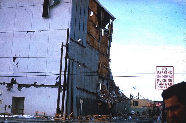
English: Two artifacts of the history of Anchorage, Alaska are found in this photo taken following the 1964 Alaska earthquake. In the foreground is the original Penney Building in Anchorage. Built in 1962 as a five-story structure, containing nearly 100,000 square feet. The building collapsed in the shaking, centered around its northeast corner and its north and east walls. The building was torn down to its foundation, and in its place was built a three-story building on a larger footprint on the same site. Directly across Fifth Avenue is the Club Rendezvous. The building shows evidence of slight damage, but is still functional. The building burned down in 1970, and despite its prime location in Anchorage's central business district, nothing was ever built on the lot to replace it. In recent years, it has been used as an outdoor seating area for a salmon bake restaurant. UPDATE: I think I snapped a few photos on this corner last summer. The salmon bake was gone. A tent retailer set up shop on the lot where the Rendezvous stood.RadioKAOS (talk) 17:47, 24 April 2014 (UTC) |
| Tanggal | |
| Sumber | http://libraryphoto.cr.usgs.gov/cgi-bin/show_picture.cgi?ID=ID.%20Alaska%20Earthquake%20no.%20%20%20%2023ct&SIZE=large Web page includes photo description |
| Pembuat | Tak diketahui |
| Lokasi kamera | | Lihat gambar ini dan gambar di sekitarnya di: OpenStreetMap |
|---|
Lisensi
Gambar ini berada di domain umum di Amerika Serikat karena gamabar ini hanya mengandung bahan yang asli berasal dari Survei Geologi Amerika Serikat, sebuah badan Departemen Dalam Negeri Amerika Serikat. Untuk informasi lebih lanjut, lihat kebijakan hak cipta Survei Geologi Amerika Serikat resmi.
|
Riwayat berkas
Klik pada tanggal/waktu untuk melihat berkas ini pada saat tersebut.
| Tanggal/Waktu | Miniatur | Dimensi | Pengguna | Komentar | |
|---|---|---|---|---|---|
| terkini | 3 Desember 2010 06.30 | | 3.582 × 2.376 (3,11 MB) | RadioKAOS | {{Information |Description={{en|1=Two artifacts of the history of Anchorage, Alaska are found in this photo taken following the 1964 Alaska earthquake. In the foreground is the original Penney Building in Anchorage. Built in 1962 as a five-story structu |
Penggunaan berkas
Halaman berikut menggunakan berkas ini:
Penggunaan berkas global
Wiki lain berikut menggunakan berkas ini:
- Penggunaan pada en.wiki-indonesia.club
- Penggunaan pada it.wiki-indonesia.club
- Penggunaan pada ko.wiki-indonesia.club