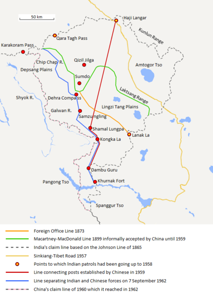
Berkas:Aksai Chin Sino-Indian border map.png

Ukuran pratayang ini: 429 × 600 piksel. Resolusi lainnya: 172 × 240 piksel | 624 × 872 piksel.
Ukuran asli (624 × 872 piksel, ukuran berkas: 102 KB, tipe MIME: image/png)
Riwayat berkas
Klik pada tanggal/waktu untuk melihat berkas ini pada saat tersebut.
| Tanggal/Waktu | Miniatur | Dimensi | Pengguna | Komentar | |
|---|---|---|---|---|---|
| terkini | 7 September 2020 20.06 |  | 624 × 872 (102 KB) | The Discoverer | Removed Tibet-Sinkiang boundary, added label for Amtogor Tso. |
| 9 Juni 2020 02.51 |  | 624 × 872 (102 KB) | MarkH21 | Intended change from the last edit (i.e. latest version with "informally" per references in talk discussion) | |
| 9 Juni 2020 02.29 |  | 624 × 872 (101 KB) | MarkH21 | Reverted to version as of 00:21, 7 February 2018 (UTC) This was the previous version; the addition of “accepted by China until 1959” was the contested change, not the revert to the original description (the refs are also now dead, but previously said tacit acceptance which isn’t outright acceptance) | |
| 23 April 2018 19.37 |  | 624 × 872 (102 KB) | The Discoverer | Reverted to version as of 09:10, 13 December 2017 (UTC) The file of 12 December removes a statement that is supported by the source. As per COM:OVERWRITE, "Controversial or contested changes should be uploaded to a separate filename" | |
| 7 Februari 2018 00.21 |  | 624 × 872 (101 KB) | 樂號 | Reverted to version as of 23:05, 12 December 2017 (UTC) | |
| 13 Desember 2017 09.10 |  | 624 × 872 (102 KB) | The Discoverer | Reverted to version as of 11:07, 19 February 2017 (UTC) The file of 12 December removes a statement that is supported by the source. As per COM:OVERWRITE, "Controversial or contested changes should be uploaded to a separate filename" | |
| 12 Desember 2017 23.05 |  | 624 × 872 (101 KB) | 樂號 | Macartney–MacDonald Line is only proposed by Britain No official accept made by China | |
| 19 Februari 2017 11.07 |  | 624 × 872 (102 KB) | The Discoverer | Added Karakoram Pass and Kunlun Range | |
| 1 April 2015 15.26 |  | 624 × 872 (59 KB) | RokerHRO | optipng -o7 -i0 → 40.77% decrease | |
| 2 Oktober 2014 15.00 |  | 624 × 872 (99 KB) | The Discoverer | Uploaded correct file with scale added. |
Penggunaan berkas
4 halaman berikut menggunakan berkas ini:
Penggunaan berkas global
Wiki lain berikut menggunakan berkas ini:
- Penggunaan pada ar.wiki-indonesia.club
- Penggunaan pada ast.wiki-indonesia.club
- Penggunaan pada as.wiki-indonesia.club
- Penggunaan pada az.wiki-indonesia.club
- Penggunaan pada bh.wiki-indonesia.club
- Penggunaan pada bn.wiki-indonesia.club
- Penggunaan pada ca.wiki-indonesia.club
- Penggunaan pada de.wiki-indonesia.club
- Penggunaan pada en.wiki-indonesia.club
- Penggunaan pada es.wiki-indonesia.club
- Penggunaan pada fr.wiki-indonesia.club
- Penggunaan pada hi.wiki-indonesia.club
- Penggunaan pada it.wiki-indonesia.club
- Penggunaan pada ja.wiki-indonesia.club
- Penggunaan pada ka.wiki-indonesia.club
- Penggunaan pada kn.wiki-indonesia.club
- Penggunaan pada ko.wiki-indonesia.club
- Penggunaan pada lv.wiki-indonesia.club
- Penggunaan pada ml.wiki-indonesia.club
- Penggunaan pada ms.wiki-indonesia.club
- Penggunaan pada nl.wiki-indonesia.club
- Penggunaan pada no.wiki-indonesia.club
- Penggunaan pada or.wiki-indonesia.club
- Penggunaan pada pl.wiki-indonesia.club
- Penggunaan pada pt.wiki-indonesia.club
- Penggunaan pada ro.wiki-indonesia.club
- Penggunaan pada ru.wiki-indonesia.club
- Penggunaan pada ru.wikinews.org
- Penggunaan pada sr.wiki-indonesia.club
- Penggunaan pada ta.wiki-indonesia.club
- Penggunaan pada te.wiki-indonesia.club
- Penggunaan pada uk.wiki-indonesia.club
- Penggunaan pada vi.wiki-indonesia.club
- Penggunaan pada zh.wiki-indonesia.club


