Berkas:Sanriku-Erdbeben.jpg

Konten halaman tidak didukung dalam bahasa lain.
Dari Wikipedia bahasa Indonesia, ensiklopedia bebas

Ukuran asli(796 × 858 piksel, ukuran berkas: 161 KB, tipe MIME: image/jpeg)

Berkas ini berasal dari Wikimedia Commons dan mungkin digunakan oleh proyek-proyek lain. Deskripsi dari halaman deskripsinya ditunjukkan di bawah ini.

Ringkasan

Deskripsi
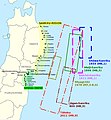
English: Historical tsunamis in the Sanriku area and selection of areas affected by the 2011 Tōhoku tsunami. (Source: Anawat Suppasri, Nobuo Shuto, Fumihiko Imamura, Shunichi Koshimura, Erick Mas, Ahmet Cevdet Yalciner: "Lessons Learned from the 2011 Great East Japan Tsunami: Performance of Tsunami Countermeasures, Coastal Buildings, and Tsunami Evacuation in Japan", Pure and Applied Geophysics, 170, (6-8), 2013, p. 993–1018, here p. 994, figure 1, DOI=10.1007/s00024-012-0511-7, online published: 7. July 2012. Modified and combined with: Nobuhito Mori, Daniel T. Cox, Tomohiro Yasuda, Hajime Mase: "Overview of the 2011 Tohoku Earthquake Tsunami Damage and Its Relation to Coastal Protection along the Sanriku Coast", Earthquake Spectra, 29 (S1), 2013, pp. 127-143, DOI=10.1193/1.4000118, here p. 131, fig. 3. And combined with: Tadashi Nakasu, Yuichi Ono, Wiraporn Pothisiri: "Why did Rikuzentakata have a high death toll in the 2011 Great East Japan Earthquake and Tsunami disaster? Finding the devastating disaster’s root causes", International Journal of Disaster Risk Reduction, Band=27, March 2018, pp. 21-36, DOI: 10.1016/j.ijdrr.2017.08.001, online published on 15 August 2017, here p. 23, fig. 1. Cf. Akemi Ishigaki, Hikari Higashi, Takako Sakamoto, Shigeki Shibahara: "The Great East-Japan Earthquake and Devastating Tsunami: An Update and Lessons from the Past Great Earthquakes in Japan since 1923", The Tohoku Journal of Experimental Medicine, 229, 4, 2013, pp. 287-299, DOI:10.1620/tjem.229.287, online published on 13 April 2013, here: p. 289, Fig. 1 "Distribution of the epicenters of the three Great Earthquakes."
Deutsch: Historische Tsunamis in der Sanriku-Region und Auswahl von Gebieten, die vom Tōhoku-Tsunami von 2011 betroffen waren. (Quelle: Anawat Suppasri, Nobuo Shuto, Fumihiko Imamura, Shunichi Koshimura, Erick Mas, Ahmet Cevdet Yalciner: "Lessons Learned from the 2011 Great East Japan Tsunami: Performance of Tsunami Countermeasures, Coastal Buildings, and Tsunami Evacuation in Japan", Pure and Applied Geophysics, 170, (6-8), 2013, S. 993–1018, hier S. 994, Abb. 1, DOI=10.1007/s00024-012-0511-7, online veröffentlicht am: 7. Juli 2012.) Verändert und kombiniert mit: Nobuhito Mori, Daniel T. Cox, Tomohiro Yasuda, Hajime Mase: "Overview of the 2011 Tohoku Earthquake Tsunami Damage and Its Relation to Coastal Protection along the Sanriku Coast", Earthquake Spectra, 29 (S1), 2013, S. 127-143, DOI=10.1193/1.4000118, hier S. 131, Abb. 3. Und kombiniert mit: Tadashi Nakasu, Yuichi Ono, Wiraporn Pothisiri: "Why did Rikuzentakata have a high death toll in the 2011 Great East Japan Earthquake and Tsunami disaster? Finding the devastating disaster’s root causes", International Journal of Disaster Risk Reduction, Band=27, März 2018, S. 21-36, DOI: 10.1016/j.ijdrr.2017.08.001, online veröffentlicht am 15. August 2017, hier S. 23, Abb. 1
Tanggal
Sumber Karya sendiri; Original for content: Anawat Suppasri, Nobuo Shuto, Fumihiko Imamura, Shunichi Koshimura, Erick Mas, Ahmet Cevdet Yalciner: "Lessons Learned from the 2011 Great East Japan Tsunami: Performance of Tsunami Countermeasures, Coastal Buildings, and Tsunami Evacuation in Japan", Pure and Applied Geophysics, 170, (6-8), 2013, p. 993–1018, DOI=10.1007/s00024-012-0511-7, online published: 7. July 2012.
Pembuat Modification and map: Anglo-Araneophilus~commonswiki, Original for content: Anawat Suppasri, Nobuo Shuto, Fumihiko Imamura, Shunichi Koshimura, Erick Mas, Ahmet Cevdet Yalciner: "Lessons Learned from the 2011 Great East Japan Tsunami: Performance of Tsunami Countermeasures, Coastal Buildings, and Tsunami Evacuation in Japan", Pure and Applied Geophysics, 170, (6-8), 2013, p. 993–1018, DOI=10.1007/s00024-012-0511-7, online published: 7. July 2012.
Izin
(Menggunakan kembali berkas ini)
w:id:Creative Commons
atribusi berbagi serupa
Berkas ini dilisensikan di bawah lisensi Creative Commons Atribusi-Berbagi Serupa 2.0 Generik
Anda diizinkan:
  • untuk berbagi – untuk menyalin, mendistribusikan dan memindahkan karya ini
  • untuk menggubah – untuk mengadaptasi karya ini
Berdasarkan ketentuan berikut:
  • atribusi – Anda harus mencantumkan atribusi yang sesuai, memberikan pranala ke lisensi, dan memberi tahu bila ada perubahan. Anda dapat melakukannya melalui cara yang Anda inginkan, namun tidak menyatakan bahwa pemberi lisensi mendukung Anda atau penggunaan Anda.
  • berbagi serupa – Apabila Anda menggubah, mengubah, atau membuat turunan dari materi ini, Anda harus menyebarluaskan kontribusi Anda di bawah lisensi yang sama seperti lisensi pada materi asli.

Captions

Add a one-line explanation of what this file represents

Items portrayed in this file

menggambarkan

31 Maret 2018

Riwayat berkas

Klik pada tanggal/waktu untuk melihat berkas ini pada saat tersebut.

Tanggal/WaktuMiniaturDimensiPenggunaKomentar
terkini14 Agustus 2018 19.09Miniatur versi sejak 14 Agustus 2018 19.09796 × 858 (161 KB)Anglo-Araneophilus~commonswikiModified and combined with: Anawat Suppasri,Yo Fukutani,Yoshi Abe,Fumihiko Imamura: "Relationship between earthquake magnitude and tsunami height along the Tohoku coast based on historical tsunami trace database and the 2011 Great East Japan Tsunami", Report of Tsunami Engineering, Vol. 30 (2013), pp. 37-49, here: Fig. 2 ("Location of tsunami affected areas and historical tsunami height distribution").
6 April 2018 08.21Miniatur versi sejak 6 April 2018 08.21796 × 858 (158 KB)Anglo-Araneophilus~commonswikiModified and combined with: Tadashi Nakasu, Yuichi Ono, Wiraporn Pothisiri: "Why did Rikuzentakata have a high death toll in the 2011 Great East Japan Earthquake and Tsunami disaster? Finding the devastating disaster’s root causes", International Journal of Disaster Risk Reduction, Band=27, March 2018, pp. 21-36, DOI: 10.1016/j.ijdrr.2017.08.001, online published on 15 August 2017.
1 April 2018 19.33Miniatur versi sejak 1 April 2018 19.33796 × 858 (150 KB)Anglo-Araneophilus~commonswikiModified and combined with: Nobuhito Mori, Daniel T. Cox, Tomohiro Yasuda, Hajime Mase: "Overview of the 2011 Tohoku Earthquake Tsunami Damage and Its Relation to Coastal Protection along the Sanriku Coast", Earthquake Spectra, 29 (S1), 2013, pp. 127-143, DOI=10.1193/1.4000118.
31 Maret 2018 15.42Miniatur versi sejak 31 Maret 2018 15.42796 × 858 (130 KB)Anglo-Araneophilus~commonswiki{{Information |description ={{en|1=Historical tsunamis in the Sanriku area and selection of areas affected by the 2011 Tōhoku tsunami. (Source: Anawat Suppasri, Nobuo Shuto, Fumihiko Imamura, Shunichi Koshimura, Erick Mas, Ahmet Cevdet Yalciner: "Lessons Learned from the 2011 Great East Japan Tsunami: Performance of Tsunami Countermeasures, Coastal Buildings, and Tsunami Evacuation in Japan", Pure and Applied Geophysics, 170, (6-8), 2013, p. 993–1018, here p. 994, figure 1, DOI=10.1007/s000...

Halaman berikut menggunakan berkas ini:

Penggunaan berkas global

Wiki lain berikut menggunakan berkas ini:

Metadata