Daerah Belait: Perbedaan antara revisi
Tampilan
Konten dihapus Konten ditambahkan
kTidak ada ringkasan suntingan |
kTidak ada ringkasan suntingan |
||
| Baris 8: | Baris 8: | ||
| settlement_type = [[Daerah di Brunei|Daerah]] |
| settlement_type = [[Daerah di Brunei|Daerah]] |
||
|image_skyline=Belait River.jpg |
|image_skyline=Belait River.jpg |
||
|imagesize=250px |
| imagesize=250px |
||
|image_caption =Sungai Belait |
| image_caption =Sungai Belait |
||
<!-- maps and coordinates ------> |
< !-- maps and coordinates ------> |
||
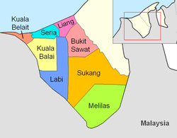
| image_map =Belait mukims.png |
| image_map =Belait mukims.png |
||
| latd = 4 | latm = 35 | lats = 14.2 | latNS = N |
| latd = 4 | latm = 35 | lats = 14.2 | latNS = N |
||
| longd = 114 | longm = 11 | longs = 32.9 | longEW = E |
| longd = 114 | longm = 11 | longs = 32.9 | longEW = E |
||
|pushpin_map =Brunei <!-- the name of a location map as per http://en.wiki-indonesia.club/wiki/Template:Location_map --> |
| pushpin_map =Brunei <!-- the name of a location map as per http://en.wiki-indonesia.club/wiki/Template:Location_map --> |
||
|pushpin_label_position = <!-- the position of the pushpin label: left, right, top, bottom, none --> |
| pushpin_label_position = <!-- the position of the pushpin label: left, right, top, bottom, none --> |
||
|pushpin_map_caption =Ibukota Daerah Belait |
| pushpin_map_caption =Ibukota Daerah Belait |
||
|pushpin_mapsize =300 |
| pushpin_mapsize =300 |
||
<!-- seat, smaller parts -------> |
<!-- seat, smaller parts -------> |
||
| seat_type = [[Ibu kota|Ibukota]] |
| seat_type = [[Ibu kota|Ibukota]] |
||
| Baris 37: | Baris 37: | ||
| elevation_max_m = 400 |
| elevation_max_m = 400 |
||
| elevation_min_footnotes = <!-- for references: use <ref> tags --> |
| elevation_min_footnotes = <!-- for references: use <ref> tags --> |
||
| elevation_min_m =0 |
| elevation_min_m = 0 |
||
<!-- population ----------------> |
<!-- population ----------------> |
||
| population_footnotes = <ref name="depd-gov-bn">{{ms}} [http://www.depd.gov.bn/DEPD%20Documents%20Library/DOS/POP/2018/Tab_MidYr2017and2018.xlsx sheet T2]</ref> |
| population_footnotes = <ref name="depd-gov-bn">{{ms}} [http://www.depd.gov.bn/DEPD%20Documents%20Library/DOS/POP/2018/Tab_MidYr2017and2018.xlsx sheet T2]</ref> |
||
Revisi per 25 April 2020 22.23
Belait
دأيره بلأيت | |
|---|---|
| Daerah Belait | |
 Sungai Belait
< !-- maps and coordinates ------> | |
 | |
| Ibukota | Kuala Belait |
| Pemerintahan | |
| • Ketua Jabatan | Awang Ramlee bin Haji Jamudin |
| • Wakil Ketua Jabatan | Awang Abdol Hazis bin Haji Ahad |
| Luas | |
| • Total | 2.727 km2 (1,053 sq mi) |
| Ketinggian tertinggi | 400 m (1,300 ft) |
| Ketinggian terendah | 0 m (0 ft) |
| Populasi (2018)[3] | |
| • Total | 73.200 |
| • Kepadatan | 27/km2 (70/sq mi) |
| Zona waktu | UTC+08:00 (WBD/BNT) |
| Kode pos | Kxxxxx |
| Kode area telepon | +673 3XX, +673 322 Seria, +673 323 Labi[4] |
| Kode ISO 3166 | BN-BE |
| Pelat kendaraan | KH dan KJ Kuala Belait KA, KB, KC, KD, KE, KF, KG, KK, KL, KM, KN, KP[5] |
| Situs web | belait |
Daerah Belait (Brunei)
Belait adalah distrik (daerah) terbesar di Brunei Darussalam, dan merupakan distrik terbarat. Ibu kotanya adalah Kuala Belait. Kota-kota utama lainnya adalah Badas, Kerangan Nyatan, Labi, Lumut, Seria, Sukang dan Telingan.
Distrik ini berbatasan dengan Laut China Selatan di utara, distrik Tutong di timur dan Malaysia di selatan dan barat.
Sungai Belait mengalir melewati Belait.
Catatan Kaki
- ^ (Melayu) http://www.moha.gov.bn/SitePages/Ketua-Ketua%20Jabatan.aspx
- ^ BELAIT DISTRICT (PDF) (Laporan) (dalam bahasa Inggris) (edisi ke-dua). Bandar Seri Begawan: Prime Minister’s Office. 2011. hlm. 8. Diakses tanggal 21 September 2019.
- ^ (Melayu) sheet T2
- ^ (Inggris) http://www.dialingcode.com/country/brunei
- ^ (Inggris) Road Traffic Act Edisi Revisi 2007 Pasal 59 Ayat 1 butir (d) pp. 28


