Ichinohe, Iwate: Perbedaan antara revisi
Tampilan
Konten dihapus Konten ditambahkan
ReneeWrites (bicara | kontrib) |
|||
| Baris 7: | Baris 7: | ||
| image_caption = Balai Kota Ichinohe |
| image_caption = Balai Kota Ichinohe |
||
| image_size = 271px |
| image_size = 271px |
||
| image_flag = Flag of Ichinohe Iwate. |
| image_flag = Flag of Ichinohe, Iwate.svg |
||
| image_seal = Emblem of Ichinohe, Iwate.svg |
| image_seal = Emblem of Ichinohe, Iwate.svg |
||
| seal_type = Emblem |
| seal_type = Emblem |
||
Revisi terkini sejak 19 April 2024 12.03
Ichinohe
一戸町 | |
|---|---|
 Balai Kota Ichinohe | |
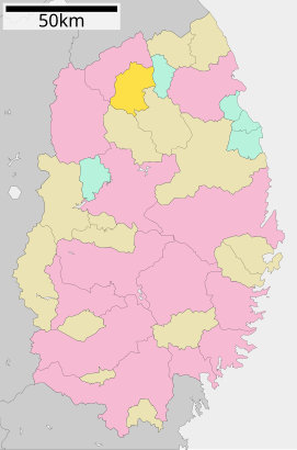
 Lokasi Ichinohe di Prefektur Iwate | |
| Koordinat: 40°12′46.4″N 141°17′43.6″E / 40.212889°N 141.295444°E | |
| Negara | |
| Wilayah | Tōhoku |
| Prefektur | |
| Distrik | Ninohe |
| Pemerintahan | |
| • Walikota | Yoshinori Onodera |
| Luas | |
| • Total | 300,03 km2 (115,84 sq mi) |
| Populasi (1 April 2020) | |
| • Total | 12,053 |
| • Kepadatan | 40,17/km2 (104,0/sq mi) |
| Zona waktu | UTC+09:00 (JST) |
| Nomor telepon | 0195-33-2111 |
| Alamat balai kota | 24-9 Aza Ōkawabachi, Kōzenji, Ichinohe-machi, Ninohe-gun, Iwate-ken 028-5391 |
| Lambang | |
| • Pohon | Ek |
| • Bunga | Sakura |
| • Burung | Yamadori (Syrmaticus soemmerringii) |
| Situs web | www |

Ichinohe (一戸町, Ichinohe-machi) adalah sebuah kota yang terletak di Prefektur Iwate, Jepang.
Per 1 April 2020, kota ini memiliki estimasi jumlah penduduk sebesar 12.053 jiwa dan kepadatan penduduk sebesar 40,17 orang per km², yang terbagi dalam 5.645 KK.[1] Kota ini memiliki luas wilayah sebesar 300,03 kilometer persegi (115,84 sq mi).
Geografi
[sunting | sunting sumber]Iklim
[sunting | sunting sumber]| Data iklim di Stasiun Oku-nakayama kōgen, Ichinohe, Iwate (1991−2020 normal, ekstrim 1977−sekarang) | |||||||||||||
|---|---|---|---|---|---|---|---|---|---|---|---|---|---|
| Bulan | Jan | Feb | Mar | Apr | Mei | Jun | Jul | Agt | Sep | Okt | Nov | Des | Tahun |
| Rekor tertinggi °C (°F) | 10.8 (51.4) |
11.2 (52.2) |
17.9 (64.2) |
26.5 (79.7) |
31.1 (88) |
30.8 (87.4) |
33.4 (92.1) |
33.5 (92.3) |
30.9 (87.6) |
26.6 (79.9) |
19.4 (66.9) |
15.1 (59.2) |
33.5 (92.3) |
| Rata-rata tertinggi °C (°F) | −1.0 (30.2) |
0.1 (32.2) |
4.1 (39.4) |
11.8 (53.2) |
18.0 (64.4) |
21.5 (70.7) |
24.5 (76.1) |
25.6 (78.1) |
21.6 (70.9) |
15.4 (59.7) |
8.3 (46.9) |
1.6 (34.9) |
12.6 (54.7) |
| Rata-rata harian °C (°F) | −4.5 (23.9) |
−3.9 (25) |
−0.3 (31.5) |
6.0 (42.8) |
12.1 (53.8) |
16.1 (61) |
19.9 (67.8) |
20.9 (69.6) |
16.7 (62.1) |
10.1 (50.2) |
3.8 (38.8) |
−1.9 (28.6) |
7.9 (46.2) |
| Rata-rata terendah °C (°F) | −9.6 (14.7) |
−9.2 (15.4) |
−5.5 (22.1) |
0.3 (32.5) |
6.1 (43) |
11.3 (52.3) |
16.2 (61.2) |
17.1 (62.8) |
12.3 (54.1) |
4.9 (40.8) |
−1.0 (30.2) |
−6.1 (21) |
3.1 (37.6) |
| Rekor terendah °C (°F) | −20.7 (−5.3) |
−21.5 (−6.7) |
−20.1 (−4.2) |
−13.2 (8.2) |
−4.2 (24.4) |
−0.2 (31.6) |
6.3 (43.3) |
6.0 (42.8) |
−0.8 (30.6) |
−4.5 (23.9) |
−13.1 (8.4) |
−18.2 (−0.8) |
−21.5 (−6.7) |
| Presipitasi mm (inci) | 51.1 (2.012) |
44.6 (1.756) |
63.2 (2.488) |
66.0 (2.598) |
83.7 (3.295) |
105.2 (4.142) |
182.6 (7.189) |
179.0 (7.047) |
155.4 (6.118) |
117.4 (4.622) |
84.2 (3.315) |
77.0 (3.031) |
1.203 (47,362) |
| Curah salju cm (inci) | 156 (61.4) |
134 (52.8) |
112 (44.1) |
16 (6.3) |
0 (0) |
0 (0) |
0 (0) |
0 (0) |
0 (0) |
0 (0) |
24 (9.4) |
133 (52.4) |
571 (224.8) |
| Rata-rata hari hujan atau bersalju (≥ 1.0 mm) | 13.1 | 12.2 | 12.4 | 11.1 | 10.9 | 10.5 | 12.6 | 12.7 | 12.5 | 12.6 | 14.0 | 14.6 | 148.0 |
| Rata-rata hari bersalju | 18.6 | 16.0 | 13.1 | 2.5 | 0.0 | 0.0 | 0.0 | 0.0 | 0.0 | 0.0 | 2.9 | 14.3 | 67.2 |
| Rata-rata sinar matahari bulanan | 69.0 | 83.5 | 129.4 | 169.8 | 189.4 | 157.1 | 127.8 | 142.7 | 130.1 | 137.7 | 106.7 | 69.9 | 1.516,2 |
| Sumber #1: JMA[2] | |||||||||||||
| Sumber #2: JMA[3] | |||||||||||||
Munisipalitas yang berdekatan
[sunting | sunting sumber]Ichinohe berbatasan dengan lima munisipalitas di wilayah Prefektur Iwate, yaitu :
Referensi
[sunting | sunting sumber]- ^ Ichinohe Town official statistics
- ^ 観測史上1~10位の値(年間を通じての値). JMA. Diakses tanggal 19 Februari 2022.
- ^ 気象庁 / 平年値(年・月ごとの値). JMA. Diakses tanggal 19 Februari 2022.
Pranala luar
[sunting | sunting sumber]Wikimedia Commons memiliki media mengenai Ichinohe, Iwate.
- Situs web resmi (dalam bahasa Jepang)


