
Leyte: Perbedaan antara revisi
Konten dihapus Konten ditambahkan
Rescuing 2 sources and tagging 0 as dead.) #IABot (v2.0.8.6 |
Tidak ada ringkasan suntingan |
||
| (10 revisi perantara oleh 4 pengguna tidak ditampilkan) | |||
| Baris 1: | Baris 1: | ||
{{ |
{{For multi|pulau yang menjadi letak provinsi ini|Pulau Leyte|munisipalitas bernama sama di dalam provinsi ini|Leyte, Leyte|provinsi lain di Filipina|Leyte Selatan}} |
||
{{Infobox settlement |
{{Infobox settlement |
||
| name = Leyte |
| name = Leyte |
||
| official_name = Provinsi Leyte<br />''Lalawigan sa Leyte''<br />''Lalawigan han Leyte'' |
| official_name = Provinsi Leyte<br />''Lalawigan sa Leyte''<br />''Lalawigan han Leyte'' |
||
| settlement_type = [[ |
| settlement_type = [[Provinsi di Filipina|Provinsi]] |
||
| image_skyline = |
| image_skyline = |
||
| image_alt = |
| image_alt = |
||
| Baris 9: | Baris 9: | ||
| image_flag = Vlag Fil Leyte.gif |
| image_flag = Vlag Fil Leyte.gif |
||
| flag_size = 120x80px |
| flag_size = 120x80px |
||
| image_seal = Leyte |
| image_seal = Leyte Province seal.svg |
||
| seal_size = 100x80px |
| seal_size = 100x80px |
||
| image_shield = |
| image_shield = |
||
| Baris 15: | Baris 15: | ||
| nickname = |
| nickname = |
||
| motto = |
| motto = |
||
| image_map = |
| image_map = Leyte in Philippines.svg |
||
| map_alt = |
| map_alt = |
||
| map_caption = |
| map_caption = Lokasi di Filipina |
||
| latd = 11 |latm = 00 |latNS = N |
| latd = 11 |latm = 00 |latNS = N |
||
| longd = 124 |longm = 51 |longEW = E |
| longd = 124 |longm = 51 |longEW = E |
||
| Baris 23: | Baris 23: | ||
| coordinates_display = inline,title |
| coordinates_display = inline,title |
||
| coordinates_region = PH |
| coordinates_region = PH |
||
| subdivision_type = [[ |
| subdivision_type = [[Daftar negara berdaulat|Negara]] |
||
| subdivision_name = {{flag| |
| subdivision_name = {{flag|Filipina}} |
||
| subdivision_type1 = |
| subdivision_type1 = Region |
||
| subdivision_name1 = |
| subdivision_name1 = Visayas Timur (Region VIII) |
||
| established_title = |
| established_title = Berdiri |
||
| established_date = 1735<ref name=leyteprov1>[http://www.cbcponline.net/jurisdictions/palo.html Archdiocese of Palo] {{Webarchive|url=https://web.archive.org/web/20120214005417/http://www.cbcponline.net/jurisdictions/palo.html |date=2012-02-14 }} Accessed August 24, 2013</ref> |
| established_date = 1735<ref name=leyteprov1>[http://www.cbcponline.net/jurisdictions/palo.html Archdiocese of Palo] {{Webarchive|url=https://web.archive.org/web/20120214005417/http://www.cbcponline.net/jurisdictions/palo.html |date=2012-02-14 }} Accessed August 24, 2013</ref> |
||
| seat_type = |
| seat_type = Ibu kota |
||
| seat = [[Tacloban]] |
| seat = [[Kota Tacloban]] |
||
| leader_party = |
| leader_party = |
||
| leader_title = [[ |
| leader_title = [[Gubernur]] |
||
| leader_name = Dominico Petilla ([[ |
| leader_name = Dominico Petilla ([[Partai Liberal (Filipina)|LP]]) |
||
| leader_title2 = [[ |
| leader_title2 = [[Wakil Gubernur]] |
||
| leader_name2 = Carlo Loreto |
| leader_name2 = Carlo Loreto ([[Partai Liberal (Filipina)|LP]]) |
||
| area_total_km2 = 6313 |
| area_total_km2 = 6313,33 |
||
| area_rank = |
| area_rank = ke-14 dari 80 |
||
| area_note = |
| area_note = Tidak termasuk Kota Tacloban |
||
| area_footnotes = <ref name=nscb>{{cite web |
| area_footnotes = <ref name=nscb>{{cite web |
||
|title=List of Provinces |
|title=List of Provinces |
||
| Baris 50: | Baris 50: | ||
| population_total = 1567984 |
| population_total = 1567984 |
||
| population_as_of = 2010 |
| population_as_of = 2010 |
||
| population_rank = |
| population_rank = ke-15 dari 80 |
||
| population_density_km2 = auto |
| population_density_km2 = auto |
||
| population_density_rank = |
| population_density_rank = ke-31 dari 80 |
||
| population_note = |
| population_note = Tidak termasuk Kota Tacloban |
||
| population_footnotes = <ref name=NSO>{{cite web |url=http://www.census.gov.ph/sites/default/files/attachments/hsd/pressrelease/Population%20and%20Annual%20Growth%20Rates%20for%20The%20Philippines%20and%20Its%20Regions%2C%20Provinces%2C%20and%20Highly%20Urbanized%20Cities%20Based%20on%201990%2C%202000%2C%20and%202010%20Censuses.pdf |title=Population and Annual Growth Rates for The Philippines and Its Regions, Provinces, and Highly Urbanized Cities |work=2010 Census and Housing Population |publisher=National Statistics Office |accessdate=12 June 2013 |archive-date=2013-09-28 |archive-url=https://web.archive.org/web/20130928012059/http://www.census.gov.ph/sites/default/files/attachments/hsd/pressrelease/Population%20and%20Annual%20Growth%20Rates%20for%20The%20Philippines%20and%20Its%20Regions%2C%20Provinces%2C%20and%20Highly%20Urbanized%20Cities%20Based%20on%201990%2C%202000%2C%20and%202010%20Censuses.pdf |dead-url=yes }}</ref> |
| population_footnotes = <ref name=NSO>{{cite web |url=http://www.census.gov.ph/sites/default/files/attachments/hsd/pressrelease/Population%20and%20Annual%20Growth%20Rates%20for%20The%20Philippines%20and%20Its%20Regions%2C%20Provinces%2C%20and%20Highly%20Urbanized%20Cities%20Based%20on%201990%2C%202000%2C%20and%202010%20Censuses.pdf |title=Population and Annual Growth Rates for The Philippines and Its Regions, Provinces, and Highly Urbanized Cities |work=2010 Census and Housing Population |publisher=National Statistics Office |accessdate=12 June 2013 |archive-date=2013-09-28 |archive-url=https://web.archive.org/web/20130928012059/http://www.census.gov.ph/sites/default/files/attachments/hsd/pressrelease/Population%20and%20Annual%20Growth%20Rates%20for%20The%20Philippines%20and%20Its%20Regions%2C%20Provinces%2C%20and%20Highly%20Urbanized%20Cities%20Based%20on%201990%2C%202000%2C%20and%202010%20Censuses.pdf |dead-url=yes }}</ref> |
||
| elevation_m = |
| elevation_m = |
||
| demographics_type1 = |
| demographics_type1 = Pembagian |
||
| demographics1_footnotes = <!-- for references: use <ref> tags --> |
| demographics1_footnotes = <!-- for references: use <ref> tags --> |
||
| demographics1_title1 = |
| demographics1_title1 = Kota mandiri |
||
| demographics1_info1 = 2 |
| demographics1_info1 = 2 |
||
| demographics1_title2 = |
| demographics1_title2 = Kota komponen |
||
| demographics1_info2 = 1 |
| demographics1_info2 = 1 |
||
| demographics1_title3 = |
| demographics1_title3 = Munisipalitas |
||
| demographics1_info3 = 40 |
| demographics1_info3 = 40 |
||
| demographics1_title4 = [[Barangay]] |
| demographics1_title4 = [[Barangay]] |
||
| demographics1_info4 = 1,393 <br>{{small| |
| demographics1_info4 = 1,393 <br>{{small|termasuk kota mandiri:}} 1,641 |
||
| demographics1_title5 = [[ |
| demographics1_title5 = [[Dewan Perwakilan Rakyat Filipina|Distrik]] |
||
| demographics1_info5 = |
| demographics1_info5 = Distrik ke-1 hingga ke-5 {{small|(termasuk [[Ormoc]] dan [[Tacloban]])}} |
||
| blank_name_sec1 = |
| blank_name_sec1 = Bahasa |
||
| blank_info_sec1 = [[Waray |
| blank_info_sec1 = [[Bahasa Waray|Waray-Waray]], [[Bahasa Cebu|Cebu]], [[Bahasa Tagalog|Tagalog]], [[Bahasa Inggris|Inggris]] |
||
| timezone = [[ |
| timezone = [[Waktu Filipina|PHT]] |
||
| utc_offset = +8 |
| utc_offset = +8 |
||
| postal_code_type = |
| postal_code_type = Kode pos |
||
| postal_code = 6500 - 6542 |
| postal_code = 6500 - 6542 |
||
| area_code_type = |
| area_code_type = Kode area telepon |
||
| area_code = 53 |
| area_code = 53 |
||
| website = {{URL|http://www.leyte.org.ph/}} |
| website = {{URL|http://www.leyte.org.ph/}} |
||
| Baris 80: | Baris 80: | ||
}} |
}} |
||
'''Leyte |
'''Leyte''' merupakan sebuah [[provinsi]] di [[Filipina]]. Ibu kotanya ialah [[Tacloban City]]. Provinsi ini terletak di region [[Visayas Timur]]. Provinsi ini memiliki luas wilayah 5.712 km² dengan memiliki jumlah penduduk 1.722.036 jiwa ([[2010]]) atau 322.579 rumah tangga. Provinsi ini memiliki angka kepadatan penduduk 301 jiwa/km². |
||
== Pembagian wilayah == |
== Pembagian wilayah == |
||
Secara administratif provinsi Leyte |
Secara administratif provinsi Leyte terbagi menjadi 40 [[munisipalitas]], 1 [[kota komponen]] dan 2 [[kota independen]], yaitu: |
||
{{col|4}} |
{{col|4}} |
||
| Baris 145: | Baris 145: | ||
{{commons category|Leyte}} |
{{commons category|Leyte}} |
||
* [http://www.leyte.org.ph/ Official Website of Leyte Province] {{Webarchive|url=https://archive. |
* [http://www.leyte.org.ph/ Official Website of Leyte Province] {{Webarchive|url=https://archive.today/20121205091516/http://www.leyte.org.ph/ |date=2012-12-05 }} |
||
* [http://newsinfo.inquirer.net/breakingnews/regions/view/20080121-113685/Poor-town-has-modern-library Inquirer.net, Poor town has modern library] |
* [http://newsinfo.inquirer.net/breakingnews/regions/view/20080121-113685/Poor-town-has-modern-library Inquirer.net, Poor town has modern library] {{Webarchive|url=https://web.archive.org/web/20080121085134/http://newsinfo.inquirer.net/breakingnews/regions/view/20080121-113685/Poor-town-has-modern-library |date=2008-01-21 }} |
||
* [http://www.nscb.gov.ph/activestats/psgc/default.asp Philippine Standard Geographic Code] {{Webarchive|url=https://web.archive.org/web/20120413163013/http://www.nscb.gov.ph/activestats/psgc/default.asp |date=2012-04-13 }} |
* [http://www.nscb.gov.ph/activestats/psgc/default.asp Philippine Standard Geographic Code] {{Webarchive|url=https://web.archive.org/web/20120413163013/http://www.nscb.gov.ph/activestats/psgc/default.asp |date=2012-04-13 }} |
||
* [http://www.census.gov.ph/data/sectordata/pop0.html 1995 Philippine Census Information] {{Webarchive|url=https://web.archive.org/web/20110624033814/http://www.census.gov.ph/data/sectordata/pop0.html |date=2011-06-24 }} |
* [http://www.census.gov.ph/data/sectordata/pop0.html 1995 Philippine Census Information] {{Webarchive|url=https://web.archive.org/web/20110624033814/http://www.census.gov.ph/data/sectordata/pop0.html |date=2011-06-24 }} |
||
* [http://www.census.gov.ph/census2000/index.html 2000 Philippine Census Information] |
* [http://www.census.gov.ph/census2000/index.html 2000 Philippine Census Information] {{Webarchive|url=https://web.archive.org/web/20100130095048/http://www.census.gov.ph/census2000/index.html |date=2010-01-30 }} |
||
* [http://www.census.gov.ph/data/pressrelease/2008/pr0830tx.html 2007 Philippine Census Information] {{Webarchive|url=https://web.archive.org/web/20090302104328/http://www.census.gov.ph/data/pressrelease/2008/pr0830tx.html |date=2009-03-02 }} |
* [http://www.census.gov.ph/data/pressrelease/2008/pr0830tx.html 2007 Philippine Census Information] {{Webarchive|url=https://web.archive.org/web/20090302104328/http://www.census.gov.ph/data/pressrelease/2008/pr0830tx.html |date=2009-03-02 }} |
||
* [http://www.blgs.gov.ph/lgpmsv2/cmshome/index.php?pageID=23&frmIdDcfCode=7&fLguType=CM&frmIdRegion=11&frmIdProvince=62 Local Governance Performance Management System] {{Webarchive|url=https://web.archive.org/web/20160422074246/http://www.blgs.gov.ph/lgpmsv2/cmshome/index.php?pageID=23&frmIdDcfCode=7&fLguType=CM&frmIdRegion=11&frmIdProvince=62 |date=2016-04-22 }} |
* [http://www.blgs.gov.ph/lgpmsv2/cmshome/index.php?pageID=23&frmIdDcfCode=7&fLguType=CM&frmIdRegion=11&frmIdProvince=62 Local Governance Performance Management System] {{Webarchive|url=https://web.archive.org/web/20160422074246/http://www.blgs.gov.ph/lgpmsv2/cmshome/index.php?pageID=23&frmIdDcfCode=7&fLguType=CM&frmIdRegion=11&frmIdProvince=62 |date=2016-04-22 }} |
||
{{coord|11|00|10|N|124|51|28|E|type:city_source:GNS-enwiki|display=title}} |
{{coord|11|00|10|N|124|51|28|E|type:city_source:GNS-enwiki|display=title}} |
||
{{Leyte |
{{Leyte}} |
||
{{Philippines political divisions}} |
{{Philippines political divisions}} |
||
{{Authority control}} |
{{Authority control}} |
||
| ⚫ | |||
[[Kategori:Leyte |
[[Kategori:Leyte| ]] |
||
[[Kategori:Provinsi di Filipina]] |
[[Kategori:Provinsi di Filipina]] |
||
| ⚫ | |||
Revisi terkini sejak 17 April 2024 15.16
Leyte | |
|---|---|
| Provinsi Leyte Lalawigan sa Leyte Lalawigan han Leyte | |
 Bendera  Lambang | |
 Lokasi di Filipina | |
| Negara | |
| Region | Visayas Timur (Region VIII) |
| Berdiri | 1735[1] |
| Ibu kota | Kota Tacloban |
| Pemerintahan | |
| • Gubernur | Dominico Petilla (LP) |
| • Wakil Gubernur | Carlo Loreto (LP) |
| Luas | |
| • Total | 6.313,33 km2 (2,437,59 sq mi) |
| Peringkat | ke-14 dari 80 |
| Tidak termasuk Kota Tacloban | |
| Populasi (2010)[3] | |
| • Total | 1.567.984 |
| • Peringkat | ke-15 dari 80 |
| • Kepadatan | 250/km2 (640/sq mi) |
| • Peringkat kepadatan | ke-31 dari 80 |
| Tidak termasuk Kota Tacloban | |
| Pembagian | |
| • Kota mandiri | 2 |
| • Kota komponen | 1 |
| • Munisipalitas | 40 |
| • Barangay | 1,393 termasuk kota mandiri: 1,641 |
| • Distrik | Distrik ke-1 hingga ke-5 (termasuk Ormoc dan Tacloban) |
| Zona waktu | UTC+8 (PHT) |
| Kode pos | 6500 - 6542 |
| Kode area telepon | 53 |
| Bahasa | Waray-Waray, Cebu, Tagalog, Inggris |
| Situs web | www |
Leyte merupakan sebuah provinsi di Filipina. Ibu kotanya ialah Tacloban City. Provinsi ini terletak di region Visayas Timur. Provinsi ini memiliki luas wilayah 5.712 km² dengan memiliki jumlah penduduk 1.722.036 jiwa (2010) atau 322.579 rumah tangga. Provinsi ini memiliki angka kepadatan penduduk 301 jiwa/km².
Pembagian wilayah[sunting | sunting sumber]
Secara administratif provinsi Leyte terbagi menjadi 40 munisipalitas, 1 kota komponen dan 2 kota independen, yaitu:
- Abuyog
- Alangalang
- Albuera
- Babatngon
- Barugo
- Bato
- Baybay
- Burauen
- Calubian
- Capoocan
- Carigara
- Dagami
- Dulag
- Hilongos
- Hindang
- Inopacan
- Isabel
- Jaro
- Javier (Bugho)
- Julita
- Kananga
- La Paz
- Leyte
- MacArthur
- Mahaplag
- Matag-ob
- Matalom
- Mayorga
- Merida
- Ormoc
- Palo
- Palompon
- Pastrana
- San Isidro
- San Miguel
- Santa Fe
- Tabango
- Tabontabon
- Tacloban
- Tanauan
- Tolosa
- Tunga
- Villaba
Galeri[sunting | sunting sumber]
-
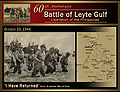 Tentara Amerika mendarat di Leyte pada tahun 1942
 -
 Leyte Provincial Capitol yang menjadi Philippine Commonwealth Government selama Perang dunia II


Referensi[sunting | sunting sumber]
- ^ Archdiocese of Palo Diarsipkan 2012-02-14 di Wayback Machine. Accessed August 24, 2013
- ^ "List of Provinces". Makati City, Philippines. Diarsipkan dari versi asli tanggal 2013-01-11. Diakses tanggal 12 June 2013.
- ^ "Population and Annual Growth Rates for The Philippines and Its Regions, Provinces, and Highly Urbanized Cities" (PDF). 2010 Census and Housing Population. National Statistics Office. Diarsipkan dari versi asli (PDF) tanggal 2013-09-28. Diakses tanggal 12 June 2013.
Pranala luar[sunting | sunting sumber]
Wikimedia Commons memiliki media mengenai Leyte.
- Official Website of Leyte Province Diarsipkan 2012-12-05 di Archive.is
- Inquirer.net, Poor town has modern library Diarsipkan 2008-01-21 di Wayback Machine.
- Philippine Standard Geographic Code Diarsipkan 2012-04-13 di Wayback Machine.
- 1995 Philippine Census Information Diarsipkan 2011-06-24 di Wayback Machine.
- 2000 Philippine Census Information Diarsipkan 2010-01-30 di Wayback Machine.
- 2007 Philippine Census Information Diarsipkan 2009-03-02 di Wayback Machine.
- Local Governance Performance Management System Diarsipkan 2016-04-22 di Wayback Machine.
Koordinat: 11°00′10″N 124°51′28″E / 11.00278°N 124.85778°E
| Munisipalitas | Abuyog • Alangalang • Albuera • Babatngon • Barugo • Bato • Burauen • Calubian • Capoocan • Carigara • Dagami • Dulag • Hilongos • Hindang • Inopacan • Isabel • Jaro • Javier • Julita • Kananga • La Paz • Leyte • MacArthur • Mahaplag • Matag-ob • Matalom • Mayorga • Merida • Palo • Palompon • Pastrana • San Isidro • San Miguel • Santa Fe • Tabango • Tabontabon • Tanauan • Tolosa • Tunga • Villaba |
|---|---|
| Kota komponen | |
| Kota independen | Ormoc • Tacloban (Secara administratif independen dari provinsi, namun oleh National Statistics Office dimasukkan ke Leyte) |

| Umum | |
|---|---|
| Perpustakaan nasional | |
| Lain-lain | |
Artikel bertopik geografi atau tempat Filipina ini adalah sebuah rintisan. Anda dapat membantu Wikipedia dengan mengembangkannya. |