
Gosong Scarborough: Perbedaan antara revisi
Konten dihapus Konten ditambahkan
k Pengembalian suntingan oleh 103.120.132.17 (bicara) ke revisi terakhir oleh HsfBot Tag: Pengembalian |
Rescuing 3 sources and tagging 0 as dead.) #IABot (v2.0.9.5 |
||
| Baris 6: | Baris 6: | ||
== Pranala luar == |
== Pranala luar == |
||
* [http://google.com/search?q=cache:5JHbkWVJCGsJ:www.vic-info.org/RegionsTop.nsf/81e4712fc4dc16ef8a25699f00062d91/bf966118eea663690a256c23006c0c90/%24FILE/Spratly%2BIslands%2BDispute%2BPrimer%2BUpdate%2B9-2-02web.doc+Spratly%2BIslands%2BDispute%2BPrimer%2BUpdate&hl=en&gl=us&ct=clnk&cd=1&client=firefox-a VirtualInformationCenter - includes many more references] |
* [http://google.com/search?q=cache:5JHbkWVJCGsJ:www.vic-info.org/RegionsTop.nsf/81e4712fc4dc16ef8a25699f00062d91/bf966118eea663690a256c23006c0c90/%24FILE/Spratly%2BIslands%2BDispute%2BPrimer%2BUpdate%2B9-2-02web.doc+Spratly%2BIslands%2BDispute%2BPrimer%2BUpdate&hl=en&gl=us&ct=clnk&cd=1&client=firefox-a VirtualInformationCenter - includes many more references] |
||
* [http://www.lib.utexas.edu/maps/middle_east_and_asia/schina_sea_88.jpg Map of the South China Sea showing Scarborough Shoal] |
* [http://www.lib.utexas.edu/maps/middle_east_and_asia/schina_sea_88.jpg Map of the South China Sea showing Scarborough Shoal] {{Webarchive|url=https://web.archive.org/web/20160305093601/http://www.lib.utexas.edu/maps/middle_east_and_asia/schina_sea_88.jpg |date=2016-03-05 }} |
||
* [http://maps.google.com/maps/ms?hl=en&t=k&ie=UTF8&msa=0&msid=112047810770307867127.0004460b96d655257cc9c&ll=18.271086,117.641602&spn=9.255025,20.566406&z=6 Google Map showing relative position of Scarborough Shoal with Philippines and China] |
* [http://maps.google.com/maps/ms?hl=en&t=k&ie=UTF8&msa=0&msid=112047810770307867127.0004460b96d655257cc9c&ll=18.271086,117.641602&spn=9.255025,20.566406&z=6 Google Map showing relative position of Scarborough Shoal with Philippines and China] {{Webarchive|url=https://web.archive.org/web/20131005065546/https://maps.google.com/maps/ms?hl=en&t=k&ie=UTF8&msa=0&msid=112047810770307867127.0004460b96d655257cc9c&ll=18.271086,117.641602&spn=9.255025,20.566406&z=6 |date=2013-10-05 }} |
||
* [http://www.dur.ac.uk/resources/ibru/publications/full/bsb7-2_keyuan.pdf Scarborough Shoal, a new Sino-Philippine conflict] |
* [http://www.dur.ac.uk/resources/ibru/publications/full/bsb7-2_keyuan.pdf Scarborough Shoal, a new Sino-Philippine conflict] {{Webarchive|url=https://web.archive.org/web/20221230205018/https://www.dur.ac.uk/resources/ibru/publications/full/bsb7-2_keyuan.pdf |date=2022-12-30 }} |
||
* [https://web.archive.org/web/20071209174605/http://www.panoramio.com/photo/5875571 Chinese marker in Panatag Shoal] |
* [https://web.archive.org/web/20071209174605/http://www.panoramio.com/photo/5875571 Chinese marker in Panatag Shoal] |
||
Revisi terkini sejak 7 Agustus 2023 21.20
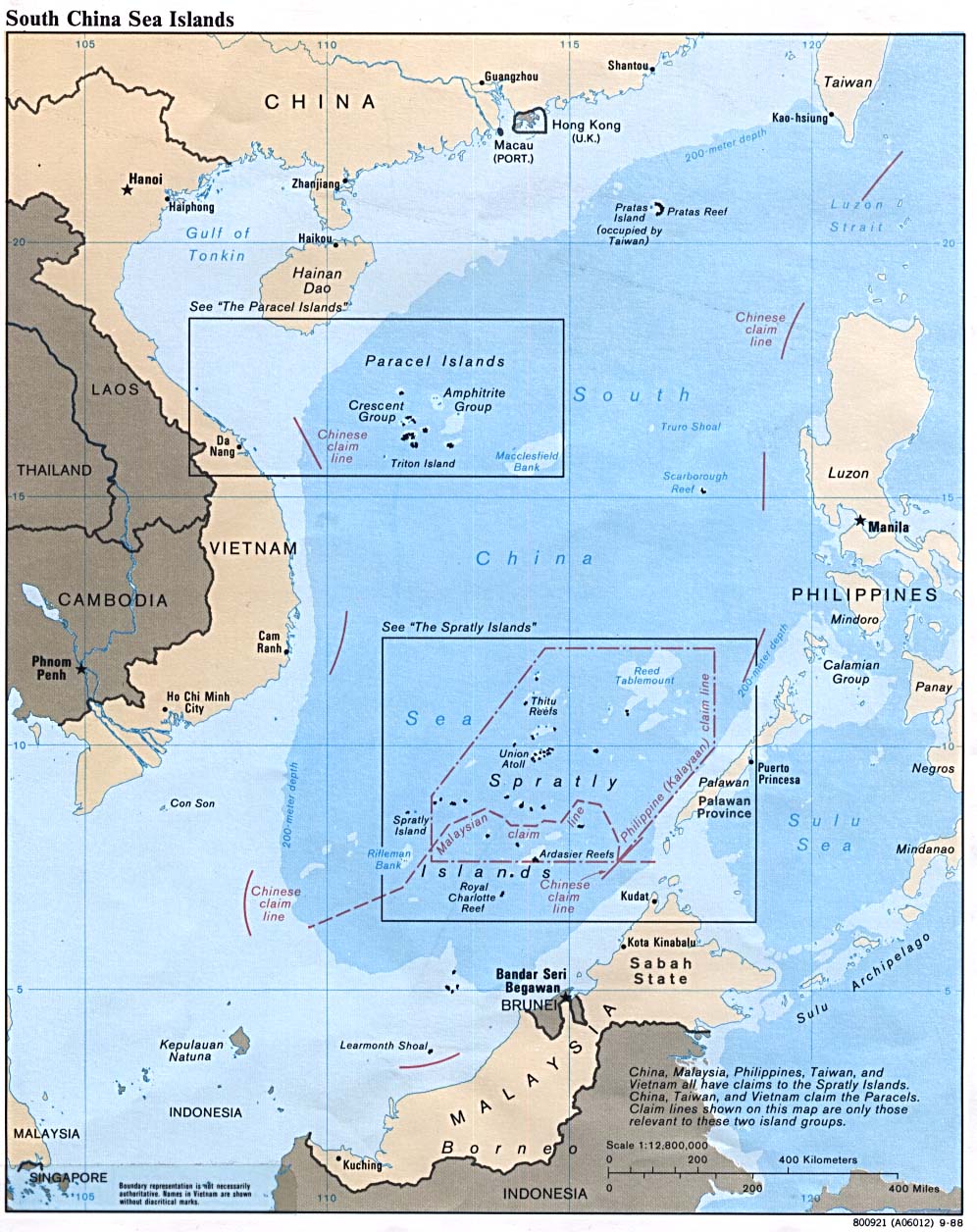
Gosong Scarborough, Karang Scarborough, atau Gosong Panatag[1] (Hanzi: 黃岩島; Pinyin: Huángyán Dǎo; Filipina: Gosong Panatag), yang lebih tepat digambarkan sebagai sekelompok pulau dan karang dalam bentuk atol daripada gosong pasir, terletak antara Macclesfield Bank dan Luzon, Filipina di Laut Tiongkok Selatan. Kepemilikan wilayah ini dipersengketakan antara Filipina, Republik Rakyat Tiongkok, dan Republik Tiongkok (Taiwan). Sebagian besar sumber memisahkan atol ini dari Kepulauan Spratly, yang terletak sejauh 350 km di sebelah barat daya.
Referensi
[sunting | sunting sumber]- ^ "The 'Spratly deal': facts & figures". The Philippine Star. 10-03-2008. Diakses tanggal 2008-08-06. [pranala nonaktif]
Pranala luar
[sunting | sunting sumber]- VirtualInformationCenter - includes many more references
- Map of the South China Sea showing Scarborough Shoal Diarsipkan 2016-03-05 di Wayback Machine.
- Google Map showing relative position of Scarborough Shoal with Philippines and China Diarsipkan 2013-10-05 di Wayback Machine.
- Scarborough Shoal, a new Sino-Philippine conflict Diarsipkan 2022-12-30 di Wayback Machine.
- Chinese marker in Panatag Shoal

Artikel bertopik geografi ini adalah sebuah rintisan. Anda dapat membantu Wikipedia dengan mengembangkannya. |