
Basilan: Perbedaan antara revisi
Konten dihapus Konten ditambahkan
k →Galeri: ++ |
|||
| Baris 88: | Baris 88: | ||
<gallery> |
<gallery> |
||
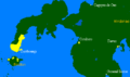
File:Ph ARMM.png|Basilan in Mindanao, Philippines (Regions IX, X, XII and ARMM) |
|||
File:Basilan Topography.jpg|Topographical map of Basilan and outlying islands |
|||
File:Old Isabela Pueblo and Plaza Rizal.jpg|Old Plaza Rizal and Plaza Misericordia, opposite Sta. Isabel Cathedral, old City Hall (Provincial Capitol) atop the hill at the background |
|||
Image:Basih weapons.jpg|Examples of finely crafted Moro blades made from Basilan "basih" (iron) |
|||
Image:Spanish map of Mindanao.jpg|The first Spanish map of Mindanao officially naming "Basilan" island (instead of Taguima/Tagyma) by Nicolas Norton Nicols, published in 1757 |
|||
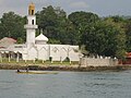
File:Sta. Isabel de Basilan.JPG|Sta. Isabel Cathedral, in the heart of Isabela City's poblacion, is the center of Basilan's thriving Catholic community |
|||
File:Ungkaya Pukan Basilan.jpg|Yakan interior/east: Yakans gathered at Materling, Al Barka (Tipo-Tipo), Basilan, visited by Kapamilya broadcaster Bernadette Sembrano |
|||
File:JS Alano Street.jpg|Christian north/northwest: J. S. Alano Street, one of the main thoroughfares of Isabela City, connecting Sta. Isabel Cathedral with the Isabela City Plaza/Plaza Rizal and the Provincial Capitol |
|||
File:Port Holland Maluso.jpg|Tausug south/southeast: Main road at Port Holland, Maluso, Basilan, flanked by Tausug traders and market stall owners |
|||
File:Basilan Ethnicity Profile.jpg|Basilan ethnicity profile |
|||
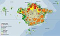
File:Basilan pop distribution.gif|Basilan Province population distribution (NSO figures 2000) |
|||
Image:Basilan students.JPG|US Ambassador Kristie Kenney with the Datu Bantilan Dance Troupe in traditional Yakan costume |
|||
File:Basilan Religious Profile.jpg|Basilan Faith Profile |
|||
Image:Kaum Purnah Mosque.JPG|Kaum Purnah Mosque, the oldest ''masjid'' on the island of Basilan |
|||
Image:Map chavacano.gif|Native Zamboangueño Chavacano speakers in Mindanao |
|||
Image:BNHS gate.JPG|Basilan National High School, Isabela City, Basilan's premier secondary institution |
|||
Image:FURIGAY COLLEGES.jpg|Furigay Colleges, Lamitan City, Basilan |
|||
File:Basilan Production Framework Map.jpg|Basilan Economic Profile |
|||
File:Quezon in Basilan.jpg|President Manuel Quezon tapping the sap of one of the trees in the pioneering Basilan rubber plantations developed by American Dr. James W. Strong |
|||
Image:Turnofthecentury Isabelawharf.jpg|USS Vicksburg coaling at the Isabela Wharf, Basilan. Photo taken from the vantage point of the "floating" Naval Hospital, 1901 |
|||
File:MNLF surrenders.jpg|MNLF Fighters surrender their firearms to President Ferdinand Marcos |
|||
Image:Ph zamboanga peninsula.png|Political map of Zamboanga Peninsula |
|||
File:Basilan security profile.jpg|Basilan security profile |
|||
Image:Rubber tree.jpg|Basilan is on its way to becoming the country's leading rubber producer once again |
|||
Image:Copra crop basilan.JPG|Copra processing plant in Isabela City, Basilan |
|||
Image:CL feeding the stocks.JPG|thumb|Samal fishers engaged in lobster culture, a project of USAID GEM on Malamawi Island, Isabela City |
|||
Image:JSAMHI.jpg|Juan S. Alano Memorial Hospital, Inc. (former Basilan Hospital), the first private hospital in Basilan, opened in 1953 |
|||
File:Malamawi Beach.JPG|Alano White Beach Resort, Malamawi Island, Isabela City, Basilan |
|||
File:Basilan Provincial Capitol.JPG|Basilan Provincial Capitol, former site of Fort Isabella Segunda |
|||
File:Lami-Lamihan Festival.jpg|Lami-Lamihan Festival, Lamitan, Basilan |
|||
File:Basilan Farmland Resort.JPG|Farmland Resort, Lanote, Isabela City, Basilan |
|||
File:Isabela City Plaza.jpg|Present-day Isabela City Plaza (formerly Plaza Misericordia; note the Rizal monument and Plaza Rizal in the background) |
|||
File:Basilan Political Map (as of 2011).jpg|Basilan political map as of 2011 |
|||
Image:Basilan Governor Jum Akbar.jpg|Slain Congressman Wahab Akbar's first wife Jum Jainuddin-Akbar casting her vote during the May 2007 elections |
|||
File:Basilan Urban Areas.jpg|Isabela City, Lamitan City and Maluso |
|||
File:Tarsier-GG.jpg|Philippine tarsier |
|||
</gallery> |
</gallery> |
||
Revisi per 26 September 2011 02.09

Basilan merupakan sebuah provinsi di Filipina. Ibu kotanya ialah Isabela City. Provinsi ini terletak di selatan Semenanjung Zamboanga. Provinsi ini memiliki luas wilayah 1.234 km² dengan memiliki jumlah penduduk 332.828 jiwa (2000) dengan memiliki angka kepadatan penduduk 210 jiwa/km².
Munisipalitas
| Kota/ Munisipalitas |
Jumlah Barangay |
Penduduk (2000) |
Area (km²) |
Kepadatan penduduk (per km²) | |
|---|---|---|---|---|---|
| Akbar | |||||
| Al-Barka | |||||
| Hadji Mohammad Ajul | |||||
| Isabela City | |||||
| Lamitan City | |||||
| Lantawan | |||||
| Maluso | |||||
| Sumisip | |||||
| Tipo-Tipo | |||||
| Tuburan | |||||
| Ungkaya Pukan | |||||
Galeri
-
 Basilan in Mindanao, Philippines (Regions IX, X, XII and ARMM)
 -
 Topographical map of Basilan and outlying islands
 -
 Old Plaza Rizal and Plaza Misericordia, opposite Sta. Isabel Cathedral, old City Hall (Provincial Capitol) atop the hill at the background
 -
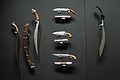 Examples of finely crafted Moro blades made from Basilan "basih" (iron)
 -
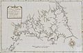 The first Spanish map of Mindanao officially naming "Basilan" island (instead of Taguima/Tagyma) by Nicolas Norton Nicols, published in 1757
 -
 Sta. Isabel Cathedral, in the heart of Isabela City's poblacion, is the center of Basilan's thriving Catholic community
 -
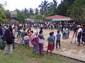 Yakan interior/east: Yakans gathered at Materling, Al Barka (Tipo-Tipo), Basilan, visited by Kapamilya broadcaster Bernadette Sembrano
 -
 Christian north/northwest: J. S. Alano Street, one of the main thoroughfares of Isabela City, connecting Sta. Isabel Cathedral with the Isabela City Plaza/Plaza Rizal and the Provincial Capitol
 -
 Tausug south/southeast: Main road at Port Holland, Maluso, Basilan, flanked by Tausug traders and market stall owners
 -
 Basilan ethnicity profile
 -
 Basilan Province population distribution (NSO figures 2000)
 -
 US Ambassador Kristie Kenney with the Datu Bantilan Dance Troupe in traditional Yakan costume
 -
 Basilan Faith Profile
 -
 Kaum Purnah Mosque, the oldest masjid on the island of Basilan
 -
 Native Zamboangueño Chavacano speakers in Mindanao
 -
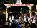 Basilan National High School, Isabela City, Basilan's premier secondary institution
 -
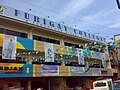 Furigay Colleges, Lamitan City, Basilan
 -
 Basilan Economic Profile
 -
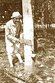 President Manuel Quezon tapping the sap of one of the trees in the pioneering Basilan rubber plantations developed by American Dr. James W. Strong
 -
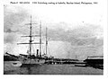 USS Vicksburg coaling at the Isabela Wharf, Basilan. Photo taken from the vantage point of the "floating" Naval Hospital, 1901
 -
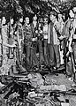 MNLF Fighters surrender their firearms to President Ferdinand Marcos
 -
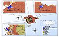
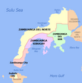 Political map of Zamboanga Peninsula
 -
 Basilan security profile
 -
 Basilan is on its way to becoming the country's leading rubber producer once again
 -
 Copra processing plant in Isabela City, Basilan
 -
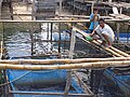 Samal fishers engaged in lobster culture, a project of USAID GEM on Malamawi Island, Isabela City
 -
 Juan S. Alano Memorial Hospital, Inc. (former Basilan Hospital), the first private hospital in Basilan, opened in 1953
 -
 Alano White Beach Resort, Malamawi Island, Isabela City, Basilan
 -
 Basilan Provincial Capitol, former site of Fort Isabella Segunda
 -
 Lami-Lamihan Festival, Lamitan, Basilan
 -
 Farmland Resort, Lanote, Isabela City, Basilan
 -
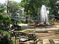 Present-day Isabela City Plaza (formerly Plaza Misericordia; note the Rizal monument and Plaza Rizal in the background)
 -
Basilan political map as of 2011
-
 Slain Congressman Wahab Akbar's first wife Jum Jainuddin-Akbar casting her vote during the May 2007 elections
 -
 Isabela City, Lamitan City and Maluso
 -
 Philippine tarsier


Pranala luar
| Munisipalitas | Akbar • Al-Barka • Hadji Mohammad Ajul • Hadji Muhtamad • Lantawan • Maluso • Sumisip • Tabuan-Lasa • Tipo-Tipo • Tuburan • Ungkaya Pukan |
|---|---|
| Kota komponen | |

.jpg)
Artikel bertopik geografi atau tempat Filipina ini adalah sebuah rintisan. Anda dapat membantu Wikipedia dengan mengembangkannya. |