
Ifugao: Perbedaan antara revisi
Konten dihapus Konten ditambahkan
k bot Menambah: it:Ifugao |
Rescuing 1 sources and tagging 0 as dead.) #IABot (v2.0.9.3 |
||
| (44 revisi perantara oleh 29 pengguna tidak ditampilkan) | |||
| Baris 1: | Baris 1: | ||
{{About||the ethnic group|Ifugao people|the language|Ifugao language|other uses}} |
|||
[[Berkas:Ph locator map ifugao.png|right|200px]] |
|||
{{Infobox settlement |
|||
'''Ifugao''' merupakan sebuah [[provinsi]] di [[Filipina]]. Ibu kotanya ialah [[Lagawe, Ifugao|Lagawe]]. Provinsi ini terletak di [[Region Administratif Cordillera]]. Provinsi ini memiliki luas wilayah 2.517 km² dengan memiliki jumlah penduduk 161.623 jiwa ([[2000]]). Provinsi ini memiliki angka kepadatan penduduk 64 jiwa/km². |
|||
| name = Ifugao |
|||
| native_name = |
|||
| other_name = |
|||
| settlement_type = [[Provinsi di Filipina|Provinsi]] |
|||
| image_skyline = Batad rice terraces in Ifugao.jpg |
|||
| image_caption = The [[Rice Terraces of the Philippine Cordilleras]], a [[UNESCO World Heritage Site]] |
|||
| image_flag = {{#property:P41}} |
|||
| flag_size = 120x80px |
|||
| image_seal = {{#property:P158}} |
|||
| seal_size = 100x80px |
|||
| image_shield = |
|||
| shield_alt = |
|||
| nickname = |
|||
| motto = |
|||
| image_map = {{#property:P242}} |
|||
| map_alt = |
|||
| map_caption = Location in the Philippines |
|||
| latd = 16 |latm = 50 |latNS = N |
|||
| longd = 121 |longm = 10 |longEW = E |
|||
| coordinates_type = region:PH_type:adm1st_source:GNS-enwiki |
|||
| coordinates_display = inline,title |
|||
| coordinates_footnotes = |
|||
| subdivision_type = [[Daftar negara berdaulat|Negara]] |
|||
| subdivision_name = [[{{#property:P17}}]] |
|||
| subdivision_type1 = [[Region di Filipina|Region]] |
|||
| subdivision_name1 = [[Cordillera Administrative Region]] (CAR) |
|||
| established_title = Didirikan |
|||
| established_date = June 18, 1966 |
|||
| seat_type = Ibukota |
|||
| seat = [[Lagawe, Ifugao|Lagawe]] |
|||
| leader_party = |
|||
| government_type = Province of the Philippines |
|||
| leader_title = [[Gubernur]] |
|||
| leader_name = Denis Habawel ([[Independent (politician)|Independent]]) |
|||
| leader_title1 = [[Wakil gubernur]] |
|||
| leader_name1 = Pedro Mayam-o ([[Partai Liberal (Filipina)|LP]]) |
|||
| area_footnotes = <ref name=list>{{cite web |title=List of Provinces |url=http://www.nscb.gov.ph/activestats/psgc/listprov.asp |work=PSGC Interactive |publisher=National Statistical Coordination Board |accessdate=20 December 2013 |location=Makati City, Philippines |archive-date=2013-01-11 |archive-url=https://web.archive.org/web/20130111015112/http://www.nscb.gov.ph/activestats/psgc/listprov.asp |dead-url=yes }}</ref> |
|||
| area_total_km2 = 2628.21 |
|||
| area_rank = 51st out of 81 |
|||
| area_note = |
|||
| population_footnotes = <ref name=NSO10>{{cite web |url=http://www.census.gov.ph/sites/default/files/attachments/hsd/pressrelease/Cordillera%20Administrative%20Region.pdf |title=Total Population by Province, City, Municipality and Barangay: as of May 1, 2010 |work=2010 Census of Population and Housing |publisher=National Statistics Office |accessdate=20 December 2013 |archive-date=2013-11-14 |archive-url=https://web.archive.org/web/20131114215915/http://www.census.gov.ph/sites/default/files/attachments/hsd/pressrelease/Cordillera%20Administrative%20Region.pdf |dead-url=yes }}</ref> |
|||
| population_total = 191078 |
|||
| population_as_of = 2010 |
|||
| population_rank = 72nd out of 81 |
|||
| population_density_km2 = auto |
|||
| population_density_rank = 74th out of 81 |
|||
| population_note = |
|||
| elevation_m = |
|||
| demographics_type1 = Divisi |
|||
| demographics1_footnotes = <!-- for references: use <ref> tags --> |
|||
| demographics1_title1 = [[Cities of the Philippines#Independent cities|Independent cities]] |
|||
| demographics1_info1 = 0 |
|||
| demographics1_title2 = [[Kota di Filipina|Kota komponen]] |
|||
| demographics1_info2 = 0 |
|||
| demographics1_title3 = [[Munisipalitas di Filipina|Munisipalitas]] |
|||
| demographics1_info3 = 11 |
|||
| demographics1_title4 = [[Barangay]] |
|||
| demographics1_info4 = [[List of barangays in Ifugao|175]] |
|||
| demographics1_title5 = [[House of Representatives of the Philippines|Districts]] |
|||
| demographics1_info5 = [[Legislative district of Ifugao|Lone district of Ifugao]] |
|||
| blank_name_sec1 = Bahasa daerah |
|||
| blank_info_sec1 = [[Ifugao language|Ifugao]], [[Ilocano language|Ilocano]], [[Tuwali language|Tuwali]], [[Ayangan language|Ayangan]], [[Kalanguya language|Kalanguya]], [[Tagalog language|Tagalog]], [[English language|English]] |
|||
| zona waktu = [[Philippine Standard Time|PHT]] |
|||
| utc_offset = +8 |
|||
| postal_code_type = [[List of ZIP codes in the Philippines|ZIP code]] |
|||
| postal_code = 3600 to 3610 |
|||
| area_code_type = [[Telephone numbers in the Philippines|Dialing code]] |
|||
| area_code = {{#property:P473}} |
|||
| iso_code = {{#property:P300}} |
|||
| website = |
|||
| footnotes = |
|||
}} |
|||
'''Ifugao''' merupakan sebuah [[provinsi]] di [[Filipina]]. Ibu kotanya ialah [[Lagawe, Ifugao|Lagawe]]. Provinsi ini terletak di [[Region Administratif Cordillera]]. Provinsi ini memiliki luas wilayah 2.628,2 km² dengan memiliki jumlah penduduk 180.711 jiwa ([[2007]]). Provinsi ini memiliki angka kepadatan penduduk 69 jiwa/km². |
|||
==Munisipalitas== |
|||
<table border="0"><tr> |
|||
<td valign="top"> |
|||
*[[Aguinaldo, Ifugao|Aguinaldo]] |
|||
*[[Alfonso Lista, Ifugao|Alfonso Lista]] (Potia) |
|||
*[[Asipulo, Ifugao|Asipulo]] |
|||
*[[Banaue, Ifugao|Banaue]] |
|||
*[[Hingyon, Ifugao|Hingyon]] |
|||
*[[Hungduan, Ifugao|Hungduan]] |
|||
</td><td valign="top"> |
|||
*[[Kiangan, Ifugao|Kiangan]] |
|||
*[[Lagawe, Ifugao|Lagawe]] |
|||
*[[Lamut, Ifugao|Lamut]] |
|||
*[[Mayoyao, Ifugao|Mayoyao]] |
|||
*[[Tinoc, Ifugao|Tinoc]] |
|||
</td></tr></table> |
|||
== Pembagian wilayah == |
|||
{{geo-stub}} |
|||
Secara administratif provinsi Ifugao terbagi menjadi 11 [[munisipalitas]], yaitu: |
|||
[[Kategori:Provinsi Filipina]] |
|||
[[ |
* [[Aguinaldo, Ifugao|Aguinaldo]] |
||
[[ |
* [[Alfonso Lista, Ifugao|Alfonso Lista]] (Potia) |
||
[[ |
* [[Asipulo, Ifugao|Asipulo]] |
||
[[ |
* [[Banaue, Ifugao|Banaue]] |
||
[[ |
* [[Hingyon, Ifugao|Hingyon]] |
||
[[ |
* [[Hungduan, Ifugao|Hungduan]] |
||
* [[Kiangan, Ifugao|Kiangan]] |
|||
[[ja:イフガオ州]] |
|||
[[ |
* [[Lagawe, Ifugao|Lagawe]] |
||
[[ |
* [[Lamut, Ifugao|Lamut]] |
||
[[ |
* [[Mayoyao, Ifugao|Mayoyao]] |
||
[[ |
* [[Tinoc, Ifugao|Tinoc]] |
||
[[war:Ifugao]] |
|||
== Galeri == |
|||
<gallery> |
|||
Berkas:Rice terraces.png|''Banaue Rice Terraces'' di provinsi Ifugao |
|||
Berkas:Traditional Ifugao House.jpg|Rumah tradisional di Ifugao menyerupai puncak gunung |
|||
</gallery> |
|||
== Referensi == |
|||
{{reflist}} |
|||
== Pranala luar == |
|||
* [http://www.nscb.gov.ph/activestats/psgc/default.asp Philippine Standard Geographic Code] {{Webarchive|url=https://web.archive.org/web/20120413163013/http://www.nscb.gov.ph/activestats/psgc/default.asp |date=2012-04-13 }} |
|||
* [http://www.census.gov.ph/census2000/index.html 2000 Philippine Census Information] |
|||
* [http://www.census.gov.ph/data/pressrelease/2008/pr0830tx.html 2007 Philippine Census Information] {{Webarchive|url=https://web.archive.org/web/20081220045058/http://www.census.gov.ph/data/pressrelease/2008/pr0830tx.html |date=2008-12-20 }} |
|||
{{coord|16|50|N|121|10|E|type:city_source:GNS-enwiki|display=title}} |
|||
{{Ifugao}} |
|||
{{Philippines political divisions}} |
|||
{{Authority control}} |
|||
{{Filipina-geo-stub}} |
|||
[[Kategori:Ifugao| ]] |
|||
[[Kategori:Provinsi di Filipina]] |
|||
Revisi terkini sejak 23 Januari 2023 16.10
Ifugao | |
|---|---|
 | |
 Bendera  Lambang | |
 Location in the Philippines | |
| Negara | Filipina |
| Region | Cordillera Administrative Region (CAR) |
| Didirikan | June 18, 1966 |
| Ibukota | Lagawe |
| Pemerintahan | |
| • Jenis | Province of the Philippines |
| • Gubernur | Denis Habawel (Independent) |
| • Wakil gubernur | Pedro Mayam-o (LP) |
| Luas | |
| • Total | 2.628,21 km2 (101,476 sq mi) |
| Peringkat | 51st out of 81 |
| Populasi (2010)[2] | |
| • Total | 191.078 |
| • Peringkat | 72nd out of 81 |
| • Kepadatan | 0,73/km2 (1,9/sq mi) |
| • Peringkat kepadatan | 74th out of 81 |
| Divisi | |
| • Independent cities | 0 |
| • Kota komponen | 0 |
| • Munisipalitas | 11 |
| • Barangay | 175 |
| • Districts | Lone district of Ifugao |
| Zona waktu | UTC+8 |
| ZIP code | 3600 to 3610 |
| Kode area telepon | 74 |
| Kode ISO 3166 | PH-IFU |
| Bahasa daerah | Ifugao, Ilocano, Tuwali, Ayangan, Kalanguya, Tagalog, English |
Ifugao merupakan sebuah provinsi di Filipina. Ibu kotanya ialah Lagawe. Provinsi ini terletak di Region Administratif Cordillera. Provinsi ini memiliki luas wilayah 2.628,2 km² dengan memiliki jumlah penduduk 180.711 jiwa (2007). Provinsi ini memiliki angka kepadatan penduduk 69 jiwa/km².
Pembagian wilayah[sunting | sunting sumber]
Secara administratif provinsi Ifugao terbagi menjadi 11 munisipalitas, yaitu:
Galeri[sunting | sunting sumber]
-
 Banaue Rice Terraces di provinsi Ifugao
 -
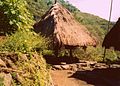 Rumah tradisional di Ifugao menyerupai puncak gunung


Referensi[sunting | sunting sumber]
- ^ "List of Provinces". PSGC Interactive. Makati City, Philippines: National Statistical Coordination Board. Diarsipkan dari versi asli tanggal 2013-01-11. Diakses tanggal 20 December 2013.
- ^ "Total Population by Province, City, Municipality and Barangay: as of May 1, 2010" (PDF). 2010 Census of Population and Housing. National Statistics Office. Diarsipkan dari versi asli (PDF) tanggal 2013-11-14. Diakses tanggal 20 December 2013.
Pranala luar[sunting | sunting sumber]
- Philippine Standard Geographic Code Diarsipkan 2012-04-13 di Wayback Machine.
- 2000 Philippine Census Information
- 2007 Philippine Census Information Diarsipkan 2008-12-20 di Wayback Machine.
Koordinat: 16°50′N 121°10′E / 16.833°N 121.167°E
| Munisipalitas | |
|---|---|

| Umum | |
|---|---|
| Perpustakaan nasional | |
Artikel bertopik geografi atau tempat Filipina ini adalah sebuah rintisan. Anda dapat membantu Wikipedia dengan mengembangkannya. |